
Iowa, Illinois and Wisconsin Face EF3 Tornado Risk Today as Upgraded Outbreak Targets Chicago to Milwaukee Corridor
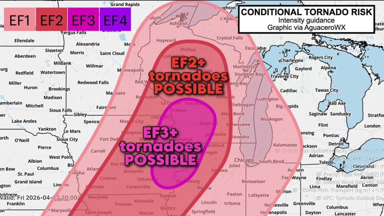
CHICAGO, Illinois — Eastern Iowa, northwestern Illinois, and southwestern Wisconsin just received an upgraded tornado risk for today, Friday April 17, and the threat level now being discussed is not a routine severe weather day — forecasters are now putting EF3+ tornadoes as a conditional possibility for a magenta zone that covers some of the most populated corridors in the Midwest.
The core of the most dangerous zone sits directly over the Rockford-Madison-Milwaukee corridor. If rotating supercells manage to form ahead of the squall line today, they could rapidly become high-end, violent storms capable of producing very large hail, damaging winds, and strong tornadoes before anyone has time to fully react.
Cities and Areas Under the Tornado Threat Right Now
- Illinois: Rockford, Chicago, Joliet, Aurora, Elgin — sitting inside the EF2+ and EF3+ conditional tornado zone
- Wisconsin: Milwaukee, Madison, Janesville, Kenosha, Racine — directly in the magenta high-end risk corridor
- Iowa: Eastern Iowa including Dubuque, Iowa City corridor — on the western edge of the upgraded risk area
- Indiana: South Bend, Fort Wayne watching the eastern flank as storms push northeast through the evening
- Michigan: Southwest Michigan including Kalamazoo and Benton Harbor on the outer edge of the threat zone
- Minnesota: Rochester and southeastern Minnesota on the northwestern boundary of the EF2+ risk area
What EF3 Conditional Risk Actually Means Today
The map breaking down today’s threat is not one that forecasters put out casually.
- EF3+ tornado zone — magenta colored, centered over the Rockford to Madison corridor — means if supercells fire ahead of the squall line, they have the atmospheric support to produce violent tornadoes reaching EF3 intensity or higher
- EF2+ tornado zone — the broader pink area covering Chicago, Milwaukee, and much of northern Illinois and southern Wisconsin — significant tornado production possible across a wide area
- EF1 and EF2 risk extends across an enormous footprint from Minnesota down through Iowa and across Indiana — no part of the region is fully out of range today
- Very large hail — the same supercells capable of producing strong tornadoes will also be throwing down baseball sized or larger hail across the risk corridor
- Damaging winds — squall line winds behind the supercell threat could produce 70+ mph straight-line wind damage across the entire region
Why the Rockford and Madison Corridor Is Ground Zero
The magenta EF3+ zone on today’s map is centered almost exactly between Rockford, Illinois and Madison, Wisconsin — two mid-sized cities with significant surrounding suburban and rural populations that would be directly exposed to any violent tornado that develops.
This zone was chosen because of the specific overlap of ingredients in that area today. The wind shear profile, the instability levels, and the low-level jet all converge most powerfully in that corridor. A supercell dropping into that environment has everything it needs to produce a long-track violent tornado.
Chicago sits just southeast of the most intense zone but remains well inside the EF2+ risk area. A city of nearly 3 million people being within the significant tornado risk footprint on any given day is a serious situation. The northern suburbs — Evanston, Waukegan, Gurnee — are closer to the core threat than downtown Chicago itself.
Milwaukee is sitting uncomfortably close to the magenta boundary. Depending on exactly where supercells initiate and how they track northeast, Milwaukee could find itself directly in the path of the most dangerous storm activity of the entire event.
The Conditional Factor and What It Means for You
The word “conditional” in today’s risk does not mean the threat is small. It means one specific thing — the worst-case scenario depends on whether discrete rotating supercells can develop ahead of the squall line before the squall line catches up and kills them.
If they do form — and the atmosphere today is absolutely loaded with the energy needed to support them — those supercells will be dangerous very quickly. The window for supercell development and the most intense tornado threat is expected during the afternoon and early evening hours today across Iowa and Illinois, pushing into Wisconsin through the evening.
If the squall line wins and supercells cannot sustain themselves, the tornado threat drops — but the damaging wind threat from the squall line itself remains very real across the entire region.
Either way, today is not a day to be casual about the weather across this part of the Midwest.
The Timeline for Today Friday April 17
Storms are expected to begin firing across eastern Iowa and northwestern Illinois during the early to mid afternoon hours as daytime heating peaks and the atmosphere destabilizes fully. This is the critical window — the first storms to fire will tell the story of whether discrete supercells can hold together.
The most dangerous period for southwestern Wisconsin and the Rockford-Madison corridor arrives during the late afternoon into early evening. As storms push northeast, Milwaukee and Kenosha enter the threat window by early evening. The squall line follows behind, sweeping damaging winds across northern Illinois, Indiana, and eventually Michigan through the late evening hours.
Nighttime tornado risk is also present as activity pushes into Indiana and Michigan after dark — and nighttime tornadoes are always more deadly because they cannot be seen and warnings are harder to act on.
What You Need to Do Right Now
- Identify your safe shelter immediately — interior room, lowest floor, away from windows — know exactly where you are going before storms arrive
- Keep your phone charged and weather alerts turned ON — tornado warnings in today’s environment could come with very little lead time
- Do not wait for a tornado warning to take action — if you are in the magenta or pink zone and a tornado watch is issued, treat it as your signal to be sheltered and ready
- Avoid mobile homes and vehicles — neither provides adequate protection from an EF2 or EF3 tornado
- Watch the sky this afternoon — rotating wall clouds, loud roaring sounds, or sudden eerie calm after heavy rain are all immediate warning signs
- Have a plan for tonight — storms push through the evening and after dark, making the overnight hours dangerous for Indiana and Michigan residents
Residents across Iowa, Illinois, Wisconsin, and neighboring states — today is the day to take the weather seriously before the first storm fires. Do not let the conditional label create a false sense of safety. The atmosphere is loaded and the threat is real.
WaldronNews.com will continue tracking today’s tornado outbreak and provide live updates as storms develop across the region this afternoon and evening.