
Virginia, Maryland and Pennsylvania Brace for Frost Monday Night as 90-Degree Heat Crashes to the 50s
WASHINGTON, D.C. — One of the sharpest temperature crashes of the spring season is about to hit the Mid-Atlantic hard. The 90-degree heat sitting over Virginia, Maryland, Pennsylvania, and Washington D.C. right now is about to be replaced by temperatures locked in the 50s — and by Monday night, frost and freeze conditions are possible across the region outside the Beltway.
A powerful cold front is barreling through the area this Sunday. Within 48 hours, the same communities sweating through summerlike heat will be pulling out jackets, covering their gardens, and watching for frost advisories as one of spring’s most dramatic weather reversals takes hold across the Mid-Atlantic.
States and Areas in the Crosshairs
- Virginia: Areas outside the Beltway at highest frost and freeze risk Monday night — rural and suburban communities especially vulnerable when winds go calm
- Maryland: Suburban and rural Maryland away from the urban core watching for frost Monday night with clear skies and dropping temperatures
- Pennsylvania: Southern Pennsylvania on the edge of the cold air push with frost concerns in outlying and elevated areas
- Washington D.C.: City itself sees the dramatic heat-to-cold crash but urban heat island offers some overnight protection compared to surrounding suburbs
- West Virginia: Mountain communities watching for snow showers Sunday night as the cold air digs in behind the front
Three Days That Tell the Whole Story
This is not a slow gentle cooldown. This is a hard, fast temperature reversal hitting the region in stages.
- Sunday — cold front barrels through, temperatures tumble sharply through the day and struggle to recover, snow showers possible in the mountains by Sunday night
- Monday — highs hold in the 50s with winds gusting 20 to 30 mph, making it feel like the upper 30s to low 40s for anyone outdoors
- Monday night — the most dangerous moment — winds go calm, skies clear, and temperatures drop into frost and freeze territory mainly outside the Beltway
A nearly 40-degree temperature swing from the current heat to Monday’s conditions is arriving faster than most people are prepared for.
Why Outside the Beltway Is the Danger Zone
Washington D.C. sits inside a well-known urban heat island — the density of concrete, buildings, and infrastructure holds warmth overnight and keeps the city a few degrees warmer than the surrounding countryside. That buffer matters on a night like Monday.
But communities across Fairfax County, Loudoun County, Prince William County in Virginia — and Montgomery County, Frederick County, Howard County in Maryland — do not have that same protection. When the wind dies down Monday night and the sky clears, those areas can drop fast. Frost on car windshields, garden plants, and exposed surfaces becomes a real and immediate concern.
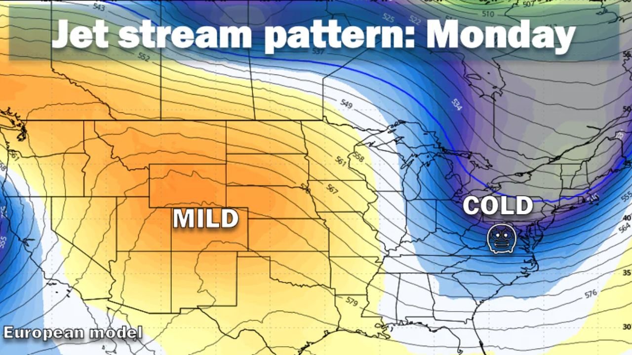
The jet stream pattern heading into Monday explains exactly why. A sharp cold trough is digging deep into the Eastern United States, locking the entire Mid-Atlantic under cold air while the western half of the country stays mild and warm. That pattern does not budge quickly once it sets up.
The Garden Warning That Cannot Wait
Anyone who got excited about the warm weather this past week and put plants in the ground needs to act right now — before Sunday.
The last frost in the colder areas of the D.C. region historically does not arrive until late April or early May. The rule that experienced local gardeners live by is simple — do not put warm-season plants outside permanently until around Mother’s Day. Monday night’s frost risk is landing right inside that vulnerable window.
Tomatoes, peppers, basil, cucumbers — any warm-season plant left outside and uncovered through Monday night could be wiped out completely. Cover what you have planted Sunday evening. Bring containers inside. Do not assume the city’s warmth will protect suburban or rural gardens.
What Comes After Monday
Tuesday begins a slow recovery, but do not expect summer to snap back immediately. The cold airmass parked over the Eastern US by the jet stream will linger through the early part of next week before any meaningful warmth starts returning from the south and west.
The contrast shown on the forecast map is striking — mild and warm across the Plains and Rockies while the entire East Coast sits under a cold, gray, breezy pattern. Washington D.C., Virginia, Maryland, and Pennsylvania will feel that contrast sharply after days of 90-degree temperatures this week.
What to Do Before Sunday Evening
- Cover or bring in any garden plants already outside — Monday night frost can kill warm-season seedlings overnight with no warning
- Locate your winter layers — the jump from 90 degrees to raw 50s with 20 to 30 mph gusts happens fast and the body does not adjust instantly
- Watch for official frost advisories Monday evening — local alerts will confirm exact timing and how cold your specific area gets
- Mountain travelers prepare for snow — West Virginia and western Virginia mountain roads could see slick conditions Sunday night
- Check on elderly neighbors and family — rapid temperature swings are hard on vulnerable people, especially those who may not have heat systems ready after weeks of warmth
Residents across Virginia, Maryland, Pennsylvania, and the Washington D.C. region should not let the current heat create a false sense that winter is finished. Monday night is the reminder that the Mid-Atlantic spring always has one more cold punch left in it.
WaldronNews.com will continue tracking this cold front and frost threat through Monday night and provide updates as conditions develop across the region.