
Wisconsin, Iowa and Illinois Face Strong Tornadoes Today as Supercells Target Chicago, Des Moines and Kansas City
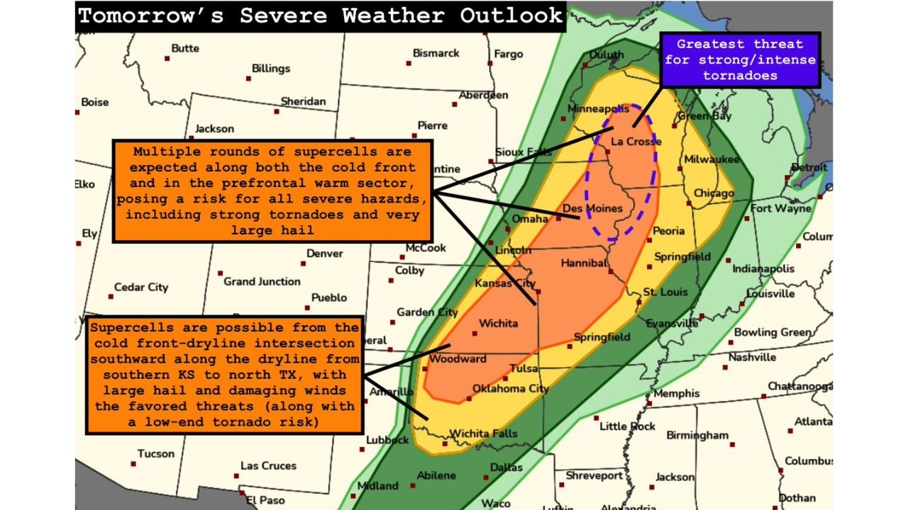
CHICAGO, Illinois — A widespread severe weather outbreak is unfolding today, Friday April 17, stretching from the Great Lakes all the way down to the Southern Plains — and the greatest threat for strong and intense tornadoes is locked in directly over Wisconsin, Iowa, and Illinois, with the bull’s eye sitting over the La Crosse to Des Moines to Peoria corridor.
Multiple rounds of supercells are expected today — both along the cold front itself and out ahead of it in the warm sector — meaning there is no single storm line to track. Different rounds of dangerous storms will be firing at different times across a massive geographic footprint, and any one of them is capable of producing strong tornadoes, very large hail, and significant damaging winds before the day is over.
Every State That Needs to Watch Today
- Wisconsin: La Crosse, Madison, Green Bay, Milwaukee — sitting inside the greatest threat zone for strong and intense tornadoes marked on today’s outlook
- Iowa: Des Moines, Iowa City, Cedar Rapids, Dubuque — directly in the bull’s eye corridor for prefrontal supercell development
- Illinois: Chicago, Rockford, Peoria, Springfield — inside the highest risk zone with supercell and tornado threat through the afternoon and evening
- Kansas: Wichita, Kansas City area, southern Kansas along the dryline — supercell development possible with large hail and damaging winds as primary threats
- Missouri: Kansas City, St. Louis, Hannibal — in the moderate risk zone with tornado potential especially if supercells hold together into the evening
- Oklahoma: Oklahoma City, Tulsa, Woodward — along the dryline where supercells could fire with large hail and a low-end tornado risk
- Texas: Wichita Falls, Amarillo corridor — dryline supercell threat with damaging winds and large hail
- Minnesota: Minneapolis, Sioux Falls area on the northern fringe of the tornado threat zone
- Indiana: Fort Wayne, Indianapolis watching the eastern push of storm activity through the evening hours
Two Separate Danger Zones Today
What makes today’s setup particularly complex — and particularly dangerous — is that there are two distinct areas where severe weather is expected to explode.
Zone 1 — The Great Lakes Tornado Corridor: This is the most dangerous area on today’s map. The dashed blue circle on the outlook sits directly over Wisconsin, Iowa, and Illinois and marks the zone with the greatest threat for strong and intense tornadoes. Prefrontal supercells firing ahead of the cold front in this area will tap into extraordinary atmospheric energy — the same setup that produced the EF3+ conditional risk discussed earlier this week. Multiple rounds of supercells are expected, meaning the threat does not end after one wave of storms passes.
Zone 2 — The Southern Plains Dryline: From southern Kansas southward through Oklahoma and into north Texas, supercells are possible along the cold front-dryline intersection. Very large hail and damaging winds are the primary threats here, but tornadoes become increasingly possible into the early evening hours as the low-level jet strengthens and discrete supercells get one final window to produce before the cold front crashes into them.
Why the Evening Hours Are Critical
The data today points to a very specific and dangerous window — the early evening hours when the low-level jet strengthens across both threat zones simultaneously.
Across the Great Lakes corridor, prefrontal supercells that fire during the afternoon could sustain themselves and intensify as the evening jet kicks in, producing long-track tornadoes after many residents have let their guard down. Across the Southern Plains, supercells that survive into early evening along the dryline get a final boost from strengthening low-level winds — the exact window when tornado production from those storms peaks.
Chicago sits close enough to the primary tornado corridor that evening storm activity pushing northeast is a direct threat to the city’s northern suburbs. Des Moines is essentially ground zero for afternoon supercell initiation. Kansas City straddles both threat zones and needs to watch storms approaching from both the northwest and the southwest simultaneously.
What Very Large Hail and Damaging Winds Mean Across This Footprint
Beyond the tornado threat, today’s outbreak covers an enormous area with very large hail and significant damaging winds that will affect communities well outside the tornado bull’s eye.
- Very large hail — stones exceeding 2 inches in diameter are likely with supercells across both the Great Lakes and Southern Plains zones — car and roof damage on a wide scale
- Significant damaging winds — squall line winds along the cold front could produce 65 to 80 mph straight-line gusts across Illinois, Indiana, Missouri, and Tennessee as the main line sweeps through
- Multiple rounds — the fact that supercells fire in waves means communities could face severe weather more than once today before conditions finally improve overnight
Your Action Plan for Today
- If you are in Wisconsin, Iowa, or Illinois — be sheltered and ready before 3 PM — this is not a wait-and-see day for the Great Lakes tornado corridor
- Kansas City, Wichita, and Oklahoma City residents — monitor the dryline storm development closely through the afternoon and keep a sharp eye on the evening window
- Have multiple ways to receive warnings — phone alerts, weather radio, local TV — supercells in multiple rounds mean warnings could come at any hour today or tonight
- Do not assume one wave passing means the threat is over — multiple rounds of supercells are explicitly expected across the Great Lakes zone
- Evening plans outdoors should be cancelled — the low-level jet strengthening after sunset makes the evening hours as dangerous as the afternoon across much of this footprint
- Indiana and Tennessee — be alert through the late evening as squall line activity pushes east and southeast after dark
From the Great Lakes to the Southern Plains, today is one of the most significant severe weather days of the 2026 spring season. The atmosphere is loaded, the setup is historic in scope, and every community inside the risk zones deserves to take this seriously right now.
WaldronNews.com will continue tracking today’s outbreak across all affected states and provide updates as storms develop, warnings are issued, and the situation evolves through tonight.