
Alabama Weekend Weather Update as Showers Move Through Tonight Lightning Possible at Tuscaloosa Birmingham and Huntsville Concerts Before Cooler Sunday
BIRMINGHAM, Alabama — A band of showers and thunderstorms is moving into northwest Alabama this Saturday evening, and while no severe weather is expected, the timing is creating a specific concern for thousands of people attending major concerts tonight in Tuscaloosa, Birmingham, and Huntsville — lightning delays are very possible as the storm band pushes through the region after 4 PM.
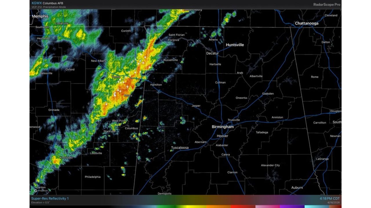
Radar from Columbus AFB at 4:18 PM Saturday is showing a continuous line of yellow, orange, and red storm cores moving northeast from Mississippi through Tupelo and Hamilton toward northwest Alabama — with the leading edge approaching the Russellville corridor and tracking toward Huntsville and Decatur through the evening hours. Birmingham and Tuscaloosa are watching the southern end of this same band push in from the west.
Alabama Communities Watching Tonight’s Showers
- Alabama: Huntsville, Decatur, Athens — in the direct path of the approaching storm band from the northwest through the evening
- Alabama: Tuscaloosa — on the southern edge of the shower corridor with lightning possible through the concert hours
- Alabama: Birmingham, Hoover, Trussville — watching the band approach with lightning potential through the metro area tonight
- Alabama: Russellville, Hamilton — already seeing the leading edge of the storm band on radar at 4:18 PM
- Alabama: Florence, Muscle Shoals — in the northern corridor as the band tracks northeast from Mississippi
- Mississippi: Tupelo, New Albany, Corinth — already inside the active storm band on radar with orange and yellow cores visible
Concert Warning for Tonight Across North Alabama
Tonight’s major concerts in Tuscaloosa, Birmingham, and Huntsville are happening directly in the path of this evening’s storm band — and lightning delays are a very real possibility for outdoor events or events with outdoor staging and queuing areas.
Concert organizers and attendees across north Alabama tonight need to be aware that the storm band moving through could produce lightning even without severe thunderstorm warnings. Standard lightning safety protocols — 30 minutes after the last lightning strike before resuming outdoor activity — could create significant delays for events scheduled during the 6 PM to 10 PM window across Tuscaloosa, Birmingham, and Huntsville.
Anyone attending outdoor events in north Alabama tonight should monitor radar closely before leaving home and have a clear understanding of the venue’s weather delay policy before the event begins.
What Tonight’s Rain Actually Delivers
The storm band moving through tonight is not a major rainfall producer for most of Alabama.
- Rain totals under half an inch across north Alabama tonight — widespread but light rainfall that will not meaningfully impact drought conditions
- Southeast Alabama communities — many areas south of Birmingham and east of Tuscaloosa may not receive enough rain to even measure by tomorrow morning
- Lightning — the primary concern tonight alongside the concert delay risk — the storm band is producing lightning across Mississippi and will continue doing so as it pushes into Alabama
- No severe thunderstorms expected — this is not a repeat of Friday’s outbreak, just a passing shower and storm band with the main impact being timing and lightning
Sunday Looks Much Better But Cooler
Once tonight’s storm band exits Alabama through the overnight hours, Sunday brings a dramatic improvement.
Sunny skies return Sunday across Alabama — but the warmth that has characterized the past several weeks does not come back with the sunshine. Highs across north Alabama on Sunday will be stuck in the 60s — a noticeable cooldown from the recent stretch of heat. South Alabama sees slightly warmer readings in the low 70s but still well below what the region has been experiencing.
The cooler Sunday is driven by the same cold air mass that is crashing temperatures across the Mid-Atlantic — the post-cold-front airmass settling across the Southeast after the weekend’s weather system passes.
The Bigger Picture — Dry Week Ahead Then Rain Returns
The 48-hour precipitation map through Monday April 20 confirms what the forecast is showing — the heaviest rain from this weekend’s system is concentrated well to the southwest across Louisiana and coastal Mississippi, where 1.0 to 1.8 inches of rainfall is falling. Alabama picks up 0.2 to 0.4 inches in the best spots — helpful but not enough to make a serious dent in the drought deficit.
Most of next week will be dry across Alabama as high pressure settles in behind this weekend’s cold front. That dry stretch is actually good news for recovery operations from the April 17 outbreak states further north, but it means Alabama’s drought situation does not improve meaningfully through mid-week.
Rain returns over the weekend of April 25 and 26 — and that weekend’s rain event carries a completely different character than tonight’s showers. The developing 30% tornado probability signal already posted for April 25 means next weekend’s rain comes with a significant severe weather component that Alabama and the broader Southeast needs to prepare for carefully.
What Alabama Residents Should Do Tonight
- Concert attendees in Tuscaloosa, Birmingham, and Huntsville — arrive with a weather app open and know your venue’s lightning delay policy before the show starts
- Do not stand outside during lightning — even without a severe thunderstorm warning, lightning from passing showers is deadly and outdoor exposure should be minimized when storms are nearby
- North Alabama residents — light rain and lightning possible through the evening hours, no major flooding or severe weather concerns but stay aware
- Plan for cooler Sunday — if you have outdoor plans Sunday, expect 60s in north Alabama — jacket weather after weeks of heat
- Begin monitoring April 25 to 26 — next weekend’s rain event is shaping up to be a significant severe weather situation for Alabama, use the dry week ahead to prepare
Alabama gets a quiet and manageable Saturday night storm band followed by a cool and sunny Sunday — before the next and potentially more significant severe weather setup arrives late next week.
WaldronNews.com will continue tracking tonight’s showers across Alabama and provide updates on the developing April 25 severe weather threat as next weekend approaches.