
Alabama, Mississippi and Tennessee Face Major Severe Weather Threat April 25 as 30 Percent Tornado Probability Targets the Southeast After Brief Quiet Period
BIRMINGHAM, Alabama — Just days after the April 17 outbreak devastated Wisconsin, Iowa, and Illinois, the atmosphere is already signaling its next major move — and this time Dixie Alley is the target. Emerging data for Saturday April 25 and Sunday April 26 is showing a significant severe weather setup developing across Alabama, Mississippi, Tennessee, Arkansas, and Georgia, with tornado probability values reaching 30% over the core threat zone and analog data showing 70 to 80% historical severe weather probability across the Southern Plains and Mid-South for that period.
This is an 8-day outlook — uncertainty exists and details will sharpen through the week. But the signal is consistent across multiple data sets and forecasters are already watching it closely. Birmingham, Jackson, Nashville, Memphis, and Little Rock are all inside the developing threat corridor for what could become one of the most significant Dixie Alley severe weather events of the spring season.
States and Cities in the April 25 to 26 Threat Window
- Alabama: Birmingham, Huntsville, Montgomery, Tuscaloosa — sitting inside the 30% tornado probability maximum on the Day 8 severe weather map
- Mississippi: Jackson, Hattiesburg, Tupelo — in the heart of the developing threat corridor where the deepest probability values are concentrated
- Tennessee: Nashville, Memphis, Chattanooga, Knoxville — across the state line and inside the significant severe weather probability zone
- Arkansas: Little Rock, Fort Smith, Jonesboro — on the western edge of the core threat with 30% probability values extending into the state
- Georgia: Atlanta, Columbus, Macon — on the eastern edge of the threat as the system pushes into the Deep South
- Kentucky: Louisville, Lexington, Bowling Green — in the northern portion of the probability zone watching the system approach from the southwest
- Virginia and North Carolina: On the far eastern edge of the probability signal as the system pushes toward the Mid-Atlantic by Sunday
What Three Separate Data Sets Are All Showing
The consistency across multiple independent forecasting tools is what makes this signal worth taking seriously a week out.
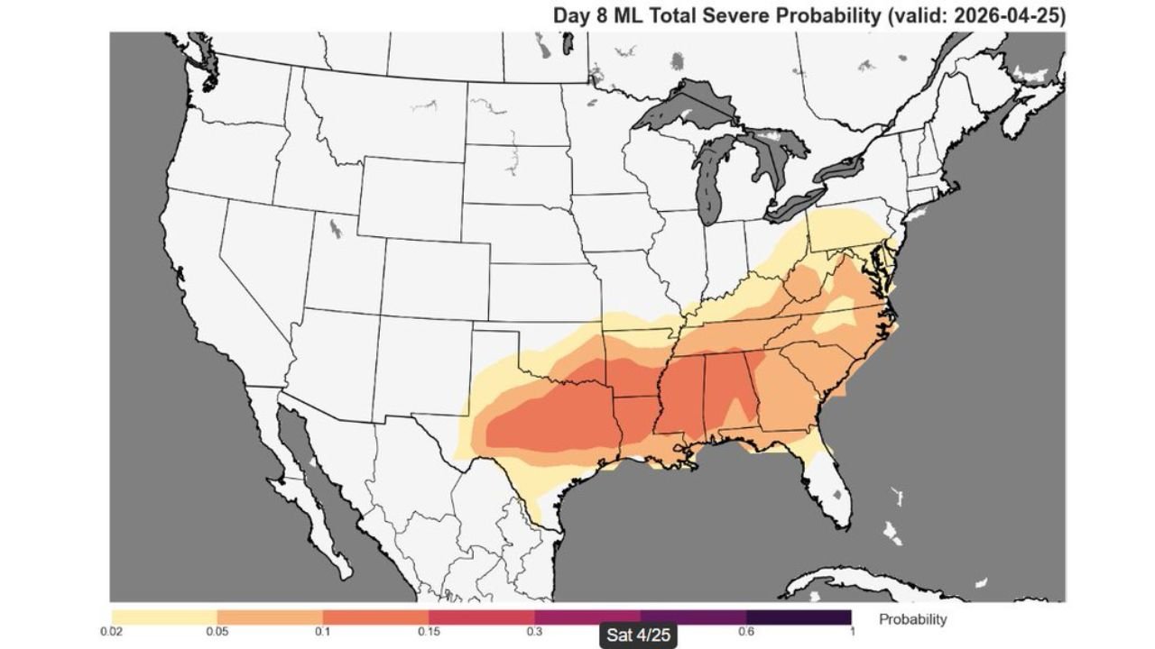
Day 8 ML Total Severe Probability map — valid Saturday April 25 — shows the maximum probability values of 30% centered directly over Mississippi, Alabama, and Arkansas. The probability field extends from Oklahoma and Arkansas in the west all the way through Tennessee, Kentucky, and into Virginia and North Carolina in the east. The 15% probability contour covers an enormous geographic footprint across the entire Southeast and Mid-Atlantic.
6 to 8 Day Analog Percentage map — valid April 23 through April 26 — shows 70 to 80% of historical analogs producing at least one severe weather report within 110 km of grid points across Kansas, Oklahoma, Arkansas, Missouri, and Tennessee. The deep orange and red core sits over Oklahoma and Kansas for the earlier days of the window, with the threat shifting east into Alabama and Mississippi by Saturday April 25.
Day 7 and Day 8 Extended Outlook maps — show 30% probability on Friday April 24 centered over Kansas and Oklahoma, then shifting to 20% probability on Saturday April 25 centered directly over Alabama, Mississippi, and Tennessee — a classic two-day progression where the Plains fires first and the Southeast gets hit the following day as the system tracks east.
The Classic Dixie Alley Setup Taking Shape
The pattern emerging for April 25 to 26 follows the same playbook that has produced some of the most devastating Dixie Alley outbreaks in history — including the April 27, 2011 Super Outbreak that remains the benchmark severe weather event for this region.
A storm system fires across the Southern Plains on Thursday and Friday April 24 — hitting Kansas and Oklahoma with the initial severe weather event already discussed earlier this week. That same system then tracks east-northeast overnight Friday into Saturday, arriving across the Mid-South and Deep South on Saturday April 25 with deep Gulf moisture, extreme instability, and powerful wind shear all aligned across Alabama, Mississippi, and Tennessee.
Birmingham sits in a geographic position that has been directly in the path of multiple historic tornado outbreaks. The April 25 probability map places the city squarely inside the highest probability values showing on the Day 8 map — a full week before the event arrives.
What the Two-Day Sequence Looks Like
Friday April 24 — The first storm system fires across Kansas and Oklahoma along the dryline with the 15% tornado probability already formally posted for that day. Supercells develop during the afternoon and track northeast through the evening.
Overnight Friday into Saturday — The storm system pushes east and southeast, crossing Missouri, Arkansas, and Tennessee while the atmosphere reloads across the Deep South.
Saturday April 25 — The primary Dixie Alley threat day. Deep Gulf moisture with dew points in the mid to upper 60s is in place across Alabama, Mississippi, and Tennessee. The approaching storm system provides the upper-level trigger and wind shear needed to fire organized supercells across the Mid-South. The 30% probability maximum sits directly over this corridor.
Sunday April 26 — The system continues pushing east into Georgia, the Carolinas, and Virginia with a 20% probability maintaining significant severe weather potential for the Eastern Seaboard as the final chapter of the two-day event plays out.
Why This Signal Deserves Attention Right Now
Eight-day outlooks carry inherent uncertainty — exact storm tracks, timing, and intensity all become clearer as the event approaches. But when three independent data sets — machine learning probability maps, historical analog matching, and extended probabilistic outlooks — all point to the same region with the same timing, that consistency is meaningful.
The 30% probability value showing on the Day 8 map for Alabama and Mississippi is not a routine signal for a week-out outlook. That level of probability, that far in advance, indicates the atmospheric pattern is strongly supportive of significant severe weather across Dixie Alley on April 25.
Forecasters note the signal extends further east than a typical Southern Plains event — potentially meaning Georgia, the Carolinas, and the Mid-Atlantic get pulled into the severe weather picture by Saturday afternoon and Sunday as the system tracks east.
What Residents Across the Southeast Should Do This Week
- Monitor forecast updates daily through Friday — the April 25 setup will become dramatically more defined as the week progresses and confidence in storm tracks, timing, and intensity increases
- Birmingham, Jackson, Nashville, and Memphis — you are in the core of the current probability maximum, use the quiet early week days to review your emergency plan and shelter location
- Have a severe weather plan confirmed before Friday evening — by the time Saturday morning arrives, the threat window will be opening and preparation time will be gone
- Arkansas and Tennessee communities — watch for the system moving through Friday night before the main Alabama-Mississippi threat Saturday
- Georgia and Carolina residents — Sunday April 26 carries its own significant probability as the system pushes east — do not assume Saturday’s event passing means the threat is over
- Do not let the 8-day timeframe create false comfort — a week moves fast, and April 25 will arrive before the forecast has fully defined the worst-case scenario
The Southeast is watching the same atmosphere that just devastated the Upper Midwest now turning its attention south. April 25 is the date to prepare for across Alabama, Mississippi, Tennessee, and the broader Dixie Alley corridor.
WaldronNews.com will continue tracking the developing April 25 severe weather threat across the Southeast and provide daily updates as the setup becomes clearer through the week.