
Kansas and Oklahoma Face Next Severe Weather Threat Thursday April 24 as Supercells and Dryline Target the Plains After Brief Quiet Period
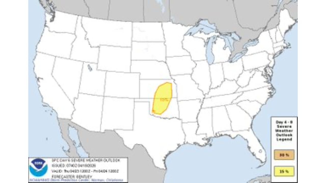
KANSAS CITY, Missouri — The April 17 outbreak recovery has barely begun across Wisconsin, Iowa, and Illinois — and the atmosphere is already reloading. After a brief 2 to 3 day quiet period starting Monday, severe weather returns to the Central Plains by Thursday April 24, with Kansas and Oklahoma already carrying a formal 15% severe weather probability for that day as a dryline and cold front set up another potentially dangerous scenario from the Plains to the Upper Midwest.
The setup arriving Thursday is still days away and carries uncertainty — but the signals are consistent enough that forecasters are already highlighting the Kansas-Oklahoma corridor as the primary area of concern. Supercells appear possible along the dryline, and the broader severe weather footprint could extend from the Central Plains all the way into the Upper Midwest depending on how the pattern evolves.
States and Cities Already in the Thursday Picture
- Kansas: Wichita, Dodge City, Liberal, Garden City, Colby — inside the formal 15% severe weather probability zone already posted for Thursday
- Oklahoma: Oklahoma City, Norman, Woodward, Enid — in the southern portion of the Thursday risk corridor along the dryline
- Nebraska: Southern Nebraska communities on the northern fringe of the developing dryline setup
- Missouri: Kansas City area watching the eastern edge of the Thursday threat as storms potentially push off the dryline
- Iowa and Upper Midwest: On the extended radar for the broader cold front severe weather signal stretching north from the Plains
What Thursday’s Setup Is Already Showing
Three separate data sets are all pointing toward the same story for Thursday April 24.
The 500 mb pattern valid Friday April 24 shows a strong trough digging into the Western United States and pushing a powerful jet stream into the Central Plains — the deep blue and purple colors on the upper-level map indicating well above normal wind speeds aloft across Kansas and Oklahoma by Thursday. That jet stream energy is the upper-level trigger that fires and organizes surface storms into supercells.
The surface dew point map valid Thursday shows Gulf moisture returning northward with dew points climbing into the upper 50s to low 60s across Oklahoma and southern Kansas — the deep moisture base needed to fuel significant storm development along the dryline.
The convective parameter map shows a focused signal of CAPE above 500 J/kg combined with bulk shear above 40 knots and convective precipitation probability above 5% concentrated over a corridor running from Kansas through the Upper Midwest — exactly the combination that produces organized supercell activity when a dryline focuses storm initiation.
The Quiet Days Before the Next Threat
Monday through Wednesday offer a genuine break from the severe weather that has dominated the Midwest and Plains since Friday. The cold air behind the April 17 outbreak settles across the region and keeps storm chances suppressed — giving communities from Madison to Des Moines to Chicago their first real opportunity to assess damage, restore power, and begin recovery operations.
That quiet period is valuable and necessary — but it is short. The same atmospheric pattern that produced back-to-back severe weather threats this weekend is not finished with the Central United States. The jet stream is cycling through another active phase by mid-week, and the Gulf moisture that retreated behind the cold front begins surging northward again by Wednesday night.
By Thursday morning, the dryline is sharpening across western Kansas and Oklahoma, Gulf moisture is in place, and the jet stream is overhead. Storm initiation is expected during the afternoon hours with the severe weather window running through the evening.
Why the Dryline Matters for Thursday
The dryline — the boundary separating dry desert air from the west and moist Gulf air from the south and east — is one of the most powerful storm triggers on the Southern Plains. When a strong jet stream passes overhead and daytime heating sharpens the dryline, supercells can fire along it rapidly and tap into the full moisture and instability of the warm sector to their east.
Thursday’s setup shows the dryline positioned across western Kansas into western Oklahoma — placing Wichita, Dodge City, Liberal, and Oklahoma City in the classic position just east of the boundary where the most violent supercells typically develop on dryline outbreak days.
The cold front approaching from the northwest adds another trigger — storms can fire both along the dryline and along the cold front, potentially creating the same bimodal threat that made Friday’s setup so widespread and dangerous across multiple states simultaneously.
How Thursday Compares to April 17
Thursday’s setup is still being defined and carries more uncertainty than Friday’s did by this same point in the forecast cycle. The convective parameter signal on Thursday is more focused and less expansive than what was showing for April 17 at this lead time — suggesting Thursday may be a more targeted and geographically concentrated event rather than a six-state outbreak.
But the 15% tornado probability already posted for Kansas and Oklahoma — days in advance — carries real weight. That level of early confidence from forecasters means the atmospheric ingredients are already aligning in a way that demands attention and preparation from Southern Plains communities before Thursday arrives.
What Kansas and Oklahoma Residents Should Do Now
- Use the quiet Monday through Wednesday window wisely — this is the time to review your emergency plan, recharge weather alert devices, and confirm your shelter location before Thursday’s threat arrives
- Wichita, Dodge City, Liberal, and Oklahoma City — you are already inside the formally outlined Thursday probability area, begin preparing now rather than waiting until Thursday morning
- Monitor forecast updates daily through Wednesday — Thursday’s setup will become significantly more defined as the week progresses and storm track confidence increases
- Do not let post-outbreak fatigue lower your guard — the atmosphere does not pause for community recovery, and Thursday deserves the same serious attention as Friday received
- Watch for tornado watch issuance Thursday morning — official watches will be the clearest signal that the severe window is opening across Kansas and Oklahoma
The Southern Plains had barely 48 hours between the end of Friday’s historic outbreak and the beginning of the next setup. Thursday April 24 is the date to watch — and the time to start watching is right now.
WaldronNews.com will continue tracking the developing Thursday severe weather threat across Kansas and Oklahoma and provide daily updates as the setup becomes clearer through the week.