
Midwest and Mid-South Face All Significant Severe Hazards Monday With Long-Tracked Tornadoes and 75 mph Wind Gusts Possible From Chicago Through Memphis
CHICAGO, Illinois — A significant severe weather event is taking shape across the Midwest and Mid-South for Monday, April 27, and forecasters are not hedging on the threat type. All significant severe hazards are possible — strong and long-tracked tornadoes, very large hail, and damaging wind gusts exceeding 75 mph — across a volatile warm sector stretching from the Chicago metro southward through St. Louis, Memphis and into Oklahoma, Arkansas, Mississippi and Tennessee. The one variable that determines whether this becomes a historic outbreak or a partially limited event remains morning convection and atmospheric recovery.
The Two Scenarios — What Morning Convection Decides
Every forecast for Monday afternoon runs through a single fork in the road: how much damage does morning convection do to the warm sector before afternoon storm development begins.
Scenario one — morning convection dominates the northern half: Even in this outcome, a significant severe weather event still occurs south of the storm-induced warm front. The southern portions of the risk area across Arkansas, Mississippi and Tennessee remain viable for severe storm development regardless of what happens to the north. This is not a washout scenario — it is a more regionally confined outbreak.
Scenario two — morning convection is more isolated and clears by late morning: A higher-end severe weather and tornado threat will likely materialize across much of the risk area. This is the scenario where the full warm sector from Chicago through Memphis becomes available for discrete supercell development simultaneously, and the outbreak potential increases dramatically.
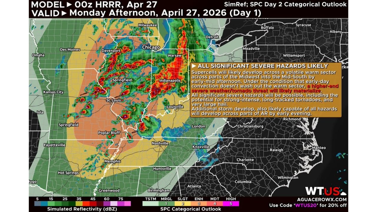
The HRRR model initialized at 00z April 27 shows the storm mode and placement for Monday afternoon, with the Enhanced and Moderate Risk zones clearly centered over the Illinois-Indiana corridor and expanding southward into the Mid-South.
The Supercell Threat — Why This Setup Supports Long-Tracked Tornadoes
The warm sector on Monday is not a marginal environment. Forecasters describe it as characterized by:
- High CAPE — Convective Available Potential Energy, the atmospheric fuel available for explosive thunderstorm development, is deep and rich across the warm sector
- Steep lapse rates — the rapid drop in temperature with altitude that drives intense updrafts inside supercell thunderstorms
- Strong low-level shear — the change in wind speed and direction near the surface that enables storm rotation and mesocyclone development
- Deep-layer shear — shear extending through the full depth of the atmosphere, sufficient to sustain long-tracked, intense supercells for extended periods
Both supercells along the cold front and supercells in the open warm sector appear possible at initiation. Open warm sector supercells are the most dangerous tornado producers because they are discrete, isolated storms with unobstructed inflow and maximum access to the instability and shear in the environment. Strong and long-tracked tornadoes will be possible with the more sustained discrete supercells before storms grow upscale.
The Wind Threat — When Storms Grow Upscale
Within the first few hours of development, storms are expected to grow upscale along the cold front, transitioning from discrete supercells into more linear, organized segments. This transition brings a shift in the primary hazard:
- The tornado threat is highest in the early discrete supercell phase before upscale growth
- Once storms organize into line segments, the damaging wind threat increases sharply
- Wind gusts with the more organized line segments may exceed 75 mph — well into the significant severe category and capable of widespread structural damage, downed trees and prolonged power outages
This dual-phase threat means residents across the risk zone face a tornado window early in the event and a damaging wind window as the evening progresses.
The Southern Extension — Oklahoma, Arkansas, Mississippi and Tennessee
The threat does not end at the Illinois and Indiana border. Further south across Oklahoma, Arkansas, Mississippi and Tennessee, an additional round of storms will likely develop by early evening, also capable of producing all severe hazards. Forecasters explicitly note it would not be a surprise to see increased severe probabilities for this region as the day progresses and the southern warm sector destabilizes through the afternoon.
The early evening development window across the southern tier means:
- Fayetteville and Fort Smith, Arkansas face storm development as the cold front pushes into the region by evening
- Memphis, Tennessee sits in the path of both the organized northern line and the developing southern activity
- Jackson, Mississippi and surrounding areas enter the threat window by late evening
- Tulsa and eastern Oklahoma could see isolated severe development ahead of the main frontal passage
Cities in the Full Risk Corridor
Primary afternoon severe weather window:
- Chicago, Illinois
- Davenport, Iowa
- Springfield, Illinois
- Indianapolis, Indiana
- St. Louis, Missouri
- Louisville, Kentucky
- Nashville, Tennessee
Early evening southern extension:
- Memphis, Tennessee
- Fayetteville, Arkansas
- Poplar Bluff, Missouri
- Huntsville, Alabama
- Birmingham, Alabama
What to Watch as Monday Unfolds
- Morning radar trends before 10 AM local — isolated, weakening convection by late morning is the signal the full severe weather window is opening across the entire risk corridor
- Discrete supercell development in the early afternoon is the highest tornado-risk moment of the day — any tornado watch issued between noon and 4 PM should be treated as an immediate shelter-now signal
- Storm mode transition timing — when storms begin growing upscale and forming line segments, shift focus from tornado sheltering to wind damage preparation
- Wind gusts above 75 mph with organized line segments are capable of downing large trees and power lines across a wide swath — secure outdoor objects and have flashlights ready before storms arrive
- Southern residents across Arkansas, Mississippi and Tennessee should not assume the threat has passed after northern storms clear — the evening development window is separate and independent
WaldronNews.com will continue tracking Monday’s severe weather outbreak across the Midwest and Mid-South and provide updates on tornado warnings, wind damage reports and storm progression as the event unfolds.