
Northern Plains Farmers Get Favorable Planting Windows in Week 2 While Ohio Valley Faces Limited Field Access as Active Pattern Persists May 4 Through May 11
FARGO, North Dakota — The Week 2 agricultural outlook brings a clear split across the central United States that will directly shape planting progress through May 4 through May 11. Farmers across the Northern Plains are looking at prolonged dry windows and favorable field conditions for corn and soybean planting, while producers across the Ohio Valley face a more active weather pattern that will limit workable days and keep fields too wet for consistent planting operations.
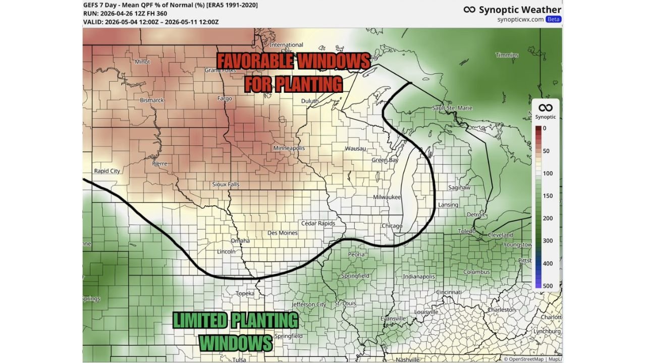
The Northern Plains — Favorable Windows Opening Up
The GEFS 7-day mean QPF percent of normal forecast valid May 4 through May 11 shows the Northern Plains running well below normal precipitation through the period. The tan and light beige shading across North Dakota, South Dakota, Minnesota and Nebraska indicates rainfall totals coming in at 50% or less of the historical average for this time of year — in some areas potentially near zero for extended stretches.
Cities and regions inside the favorable planting zone:
- Fargo, North Dakota — below normal precipitation, extended dry windows expected
- Bismarck, North Dakota — favorable field conditions through much of the week
- Grand Forks, North Dakota — prolonged dry stretches ideal for planting operations
- Minot, North Dakota — well inside the favorable zone
- Pierre, South Dakota — below normal rainfall supporting fieldwork
- Sioux Falls, South Dakota — on the southern edge of the favorable window
- Minneapolis and St. Paul, Minnesota — positioned inside the drier pattern for most of the week
For producers in these areas, the Week 2 window represents a meaningful opportunity to make significant planting progress on corn and soybeans after a wet and active late April. Prolonged dry windows in May are operationally valuable — they allow soils to firm up, equipment to run at full capacity and planting to proceed across multiple consecutive days without weather delays.
The Ohio Valley — Active Pattern Limits Field Access
South and east of the dividing line — which runs roughly from Omaha through Des Moines, Chicago and into the Great Lakes — the story is the opposite. The Ohio Valley and surrounding region faces a more active Week 2 with above normal precipitation keeping fields wet and planting windows limited.
The green shading on the forecast map covering Illinois, Indiana, Ohio, Kentucky and surrounding states indicates precipitation running at 150% or more of normal through the May 4 through May 11 period. A few dry days may occur within this window, but they will be interrupted by additional storm systems that reset field conditions and push back planting timelines.
Cities and regions facing limited planting windows:
- Indianapolis, Indiana — active pattern, multiple wet days expected
- Columbus, Ohio — above normal precipitation limiting fieldwork
- Cincinnati, Ohio — well inside the wet zone through the period
- Louisville, Kentucky — limited dry windows amid active storm pattern
- Evansville, Indiana — below the favorable line, facing continued wet conditions
- St. Louis, Missouri — on the boundary, some dry days possible but not consistent
- Peoria and Springfield, Illinois — active pattern reducing planting opportunity
Why This Split Matters for the Planting Calendar
May 4 through May 11 falls inside a critical planting window for corn across the central United States. Agronomists generally consider mid-May the soft deadline for optimal corn yield potential across the northern Corn Belt — planting after that window begins to carry meaningful yield drag. A week of favorable conditions in the Northern Plains during this window allows producers to bank planting progress when it matters most.
The Ohio Valley situation is more complicated. Producers there are already dealing with the aftermath of the late April severe weather and heavy rainfall event that pushed through Illinois, Indiana and Kentucky. Week 2 bringing continued above normal precipitation means cumulative soil moisture in that region may reach levels where field conditions do not recover to workable status even on the brief dry days embedded in the active pattern.
What Farmers Should Watch Through the Week
- Northern Plains producers should monitor the exact dry window timing — the favorable pattern is real but not necessarily wall-to-wall dry. Brief disturbances may bring light rain even in the favorable zone, so watching short-range forecasts for the specific planting days matters
- Ohio Valley producers should identify the 1 to 2 day dry windows within the active pattern and prioritize the highest ground and best-draining fields for any planting that does occur
- The dividing line between favorable and limited zones runs through Iowa, Illinois and the Great Lakes — producers near that boundary face the most uncertainty and should watch forecast updates closely as the line can shift north or south by 50 to 100 miles between model runs
- Soil temperature trends matter alongside precipitation — even in the favorable Northern Plains zone, soils need to hold at or above 50°F at 2-inch depth for optimal corn germination, and the cooler pattern following late April could be a secondary factor for the northernmost production areas
WaldronNews.com will continue tracking Week 2 planting conditions across the Northern Plains and Ohio Valley and provide updates on field condition forecasts and planting window timing as the pattern evolves through early May.