
Kentucky Faces Two Separate Severe Weather Windows Monday With Supercells Targeting Western Kentucky Before a Damaging Wind Line Pushes Toward Interstate 65 Around Midnight
LOUISVILLE, Kentucky — Monday’s severe weather threat across Kentucky is not a single event arriving and departing cleanly. Forecasters are tracking two distinct severe weather windows for the state, separated by timing and geography, each carrying its own hazard profile. The first arrives along the Interstate 64 corridor and the Parkways during the late afternoon and early evening. The second — and more significant — arrives overnight as supercells fire along the cold front, track toward western Kentucky and then congeal into a damaging wind line pushing toward Interstate 65 around midnight.
Area 1 — Interstate 64 and the Parkways, 6 to 10 PM
The first severe weather window is a conditional risk for Kentucky, meaning it depends on upstream storm evolution and atmospheric recovery through the afternoon. The timing for this area is 6 to 10 PM along the Interstate 64 corridor and the Parkway system that runs through central Kentucky.
This is the earlier, more uncertain of the two threats. Whether it materializes at full potential depends on how much instability remains available in the warm sector after afternoon storm activity consumes part of the atmospheric fuel load. Residents along Interstate 64 — from Louisville eastward through Lexington and into the Bluegrass region — should have weather alerts active through the early evening hours and be prepared to act quickly if warnings are issued, even if the threat ultimately comes in below its maximum potential.
Area 2 — Supercells Into Western Kentucky, Late Evening Into Overnight
The second window is the higher-confidence and higher-severity threat for Kentucky. As the cold front pushes eastward through the overnight hours, supercells will fire along the front and track toward western Kentucky. In their initial discrete phase, these supercells must be watched for all severe hazards — tornadoes, large hail and damaging winds are all possible from organized rotating storms before they lose their discrete character.
The storm evolution then follows a predictable but dangerous pattern:
- Supercells congeal into a line as they interact with each other and the cold front’s forcing mechanism dominates over individual storm dynamics
- The tornado threat decreases as discrete supercell character is lost
- The damaging wind threat increases sharply as the organized line accelerates eastward
- The line pushes toward Interstate 65 around midnight — covering the Louisville metro corridor and the communities along that north-south spine through central Kentucky
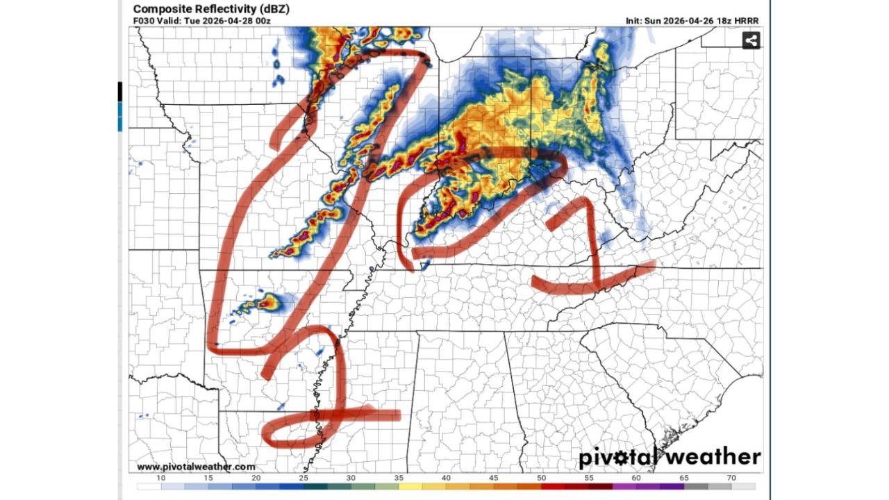
The HRRR forecast radar valid Tuesday April 28 at 00Z — midnight Monday night — shows the storm line position clearly, with intense red and orange reflectivity cores lined up along a southwest-to-northeast axis across Kentucky, consistent with the described overnight evolution.
The Two-Phase Hazard Breakdown for Kentucky
Phase 1 — 6 to 10 PM along Interstate 64 and the Parkways:
- Conditional severe weather risk
- All hazards possible if the window opens
- Timing dependent on upstream storm evolution
Phase 2 — Late evening into overnight, western Kentucky into Interstate 65:
- Supercells firing along the cold front tracking toward western Kentucky
- All hazards at first — tornado, large hail, damaging winds from discrete supercells
- Storm mode transition to squall line
- Damaging winds and isolated tornado threat with the organized line
- Line reaches Interstate 65 corridor around midnight
Cities in Each Threat Window
Interstate 64 and Parkways corridor — 6 to 10 PM:
- Louisville, Kentucky
- Lexington, Kentucky
- Elizabethtown, Kentucky
- Frankfort, Kentucky
- Bowling Green, Kentucky
Western Kentucky supercell and overnight line — late evening into midnight:
- Paducah, Kentucky
- Owensboro, Kentucky
- Hopkinsville, Kentucky
- Madisonville, Kentucky
- Bowling Green, Kentucky — in the path of the line approaching Interstate 65
- Louisville, Kentucky — Interstate 65 corridor arrival around midnight
What Makes the Overnight Window More Dangerous
The supercell-to-squall-line evolution overnight introduces the same visibility problem that makes nighttime severe weather disproportionately deadly. When supercells are tracking toward western Kentucky in the late evening hours, darkness eliminates visual tornado detection. When the line arrives at Interstate 65 around midnight, most residents will be asleep.
The combination of:
- Overnight timing — warnings arrive when people are least prepared to respond
- Rain-wrapped storms — supercells embedded in heavy precipitation are invisible even with outdoor lighting
- Rapid storm mode transition — the shift from supercell to squall line happens faster than many people can track
…makes multiple simultaneous alert sources essential. A single phone alert is not a sufficient warning system for a midnight severe weather event.
What Kentucky Residents Need to Do Before Monday Evening
- Identify your shelter location now — basement or interior room on the lowest floor of a permanent structure
- Set NOAA weather radio to alert through the night — do not rely solely on a phone that may be silenced during sleep
- Residents along Interstate 64 and the Parkways should be weather-aware from 6 PM onward, with alerts active through 10 PM
- Western Kentucky residents from Paducah through Owensboro and Hopkinsville face the first supercell window and should be sheltered and alert from late evening onward
- Everyone along the Interstate 65 corridor — particularly Louisville — should treat midnight as a hard shelter deadline regardless of whether earlier activity has occurred
WaldronNews.com will continue tracking Monday’s two-phase severe weather threat across Kentucky and provide updates on supercell development, storm mode transition and wind damage reports through Monday night.