
Birmingham and Tuscaloosa Severe Weather Threat Drops Significantly as Rain-Cooled Air Stabilizes Alabama Tuesday Evening
BIRMINGHAM, Alabama — The severe weather picture across Alabama has shifted favorably as of the 5:25 PM Central Tuesday evening update. A messy mass of rain and thunderstorms covers the Deep South, but no severe weather warnings are active across Alabama at this hour. The rain-cooled air that has settled across the state following the passage of earlier storm activity is doing exactly what forecasters hoped — stabilizing the atmosphere and reducing the odds of organized severe weather for the remainder of the evening.
Why the Threat Is Diminishing
The key atmospheric mechanism working in Alabama’s favor tonight is rain-cooled air. As the heavy rainfall from the afternoon storm complex spread across the state, it evaporated into the lowest levels of the atmosphere and cooled the surface air significantly. This cooling stabilizes the boundary layer — the lowest portion of the atmosphere that severe thunderstorms depend on for warm, unstable surface air as their fuel source.
When the boundary layer cools, CAPE — Convective Available Potential Energy — drops rapidly. Without sufficient CAPE, even a favorable upper-level pattern and strong wind shear cannot produce organized severe weather. The rain-cooled air has effectively capped the atmosphere from below rather than from above, and that stabilization is likely to persist through the evening.
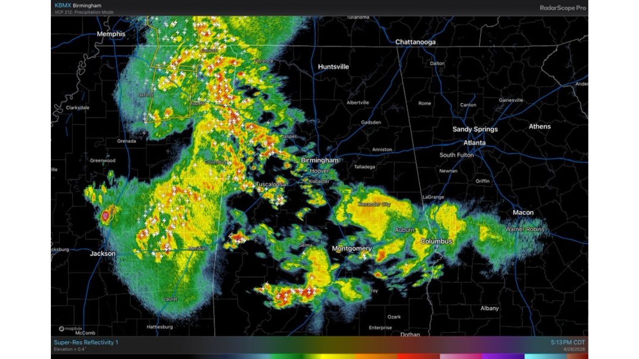
What the Radar Shows at 5:13 PM
The KBMX Birmingham radar at 5:13 PM CDT shows the current storm picture across Alabama and the surrounding region. The most intense activity — indicated by red and orange cores — is concentrated across the western Alabama corridor from Tuscaloosa northward through Decatur, Oxford and Jasper, tracking toward the Tennessee state line. Lightning bolt symbols are widespread across this line, confirming active thunderstorm activity throughout the corridor.
Central and southern Alabama from Montgomery through Dothan shows significantly lighter activity — scattered yellow and green returns indicating rain without organized thunderstorm structure. The Birmingham metro sits between the active northern line and the lighter southern activity, currently in a transitional zone.
The MRMS composite reflectivity at 5:12 PM CDT shows the broader regional picture. The storm complex covers a broad swath from Jackson, Tennessee through Corinth and Tupelo, Mississippi southward through Birmingham and into Montgomery, with the eastern extent reaching Columbus, Georgia and Macon. A separate area of active convection is ongoing near Jackson, Mississippi to the west.
The Next Storm Area — Moving in From Mississippi
An additional area of rain and storms will move into Alabama from Mississippi through the evening. This is the system that requires continued radar monitoring despite the currently favorable conditions. However, forecasters are explicit: with so much rain-cooled air already in place across Alabama, the odds of this next area producing major severe weather problems are looking increasingly low.
The most likely hazards with the incoming Mississippi-sourced activity:
- Some hail — possible with the stronger cells but not the large, destructive hail that characterized the afternoon supercell environment
- Gusty winds — scattered wind gusts with stronger storm cells as the system crosses the state line
- Heavy rainfall — the primary concern for areas already saturated from afternoon activity, where additional rain could cause localized flooding
The Late April Caveat
Forecasters are careful to note that this is late April — a time of year when atmospheric conditions can shift rapidly and unexpected storm development remains possible even when the overall pattern looks favorable. The radar will be watched closely through the evening and any new organized severe weather development will be flagged immediately.
Cities Still Experiencing Active Weather
Active storm corridor — northern Alabama:
- Decatur, Alabama
- Oxford, Alabama
- Jasper, Alabama
- Tuscaloosa, Alabama
- Florence, Alabama
Lighter rain — central and southern Alabama:
- Birmingham, Alabama — transitional zone, lighter activity
- Montgomery, Alabama — scattered rain, no organized severe threat
- Dothan, Alabama — light to moderate rain
Next incoming area — watching closely:
- Meridian, Mississippi — storm area tracking toward the Alabama state line
- Columbus, Mississippi — additional activity that will push into western Alabama through the evening
What Alabama Residents Should Do Tonight
- The severe weather emergency is substantially reduced for Alabama as of this update — residents can stand down from immediate shelter readiness but should keep weather alerts active
- Northern Alabama from Decatur through Huntsville and the Tennessee Valley still has active thunderstorms ongoing and should remain weather aware through 8 PM
- Watch for the next storm area arriving from Mississippi — if any cells show unexpected intensification as they cross into Alabama, warnings could still be issued even in the stabilized environment
- Low-lying areas that received heavy rainfall this afternoon should watch for continued water accumulation as additional rain moves through tonight
WaldronNews.com will continue monitoring Tuesday evening storm activity across Alabama and provide updates if conditions change through the overnight hours.