
Dallas, Oklahoma City and Little Rock Face Final Robust Severe Weather Day With Giant Hail and Tornadoes Possible as MCS Targets Memphis and Birmingham
DALLAS, Texas — Tuesday April 28 marks the final robust day in an extended multiday severe weather sequence that has battered the central United States since the weekend, and it is not going out quietly. Widespread convection is expected across the Enhanced Risk area, split into two distinct storm modes — an MCS taking shape to the east targeting Memphis and Birmingham with damaging winds, and semi-discrete supercells to the west carrying giant hail and tornado potential across Oklahoma, north Texas and the Arklatex.
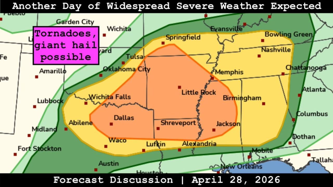
The Two-Mode Severe Weather Setup
The forecast for April 28 divides cleanly into an eastern and western threat, each operating on different atmospheric dynamics but both capable of significant severe weather impacts.
Western Zone — Semi-Discrete Supercells, Giant Hail and Tornadoes: The orange Enhanced Risk zone covering Oklahoma City, Tulsa, Dallas, Wichita Falls, Shreveport and Little Rock is the supercell environment. Semi-discrete storms — cells that are partially separated from each other rather than fully merged into a line — retain enough individual character to develop organized mesocyclones capable of producing giant hail and tornadoes. The pink label on the forecast map is explicit: tornadoes and giant hail possible across this western corridor.
Giant hail — defined as stones 2 inches or larger — causes catastrophic damage to vehicles, roofs and any exposed property. In an environment supporting semi-discrete supercells with strong updrafts, giant hail can reach baseball to softball sizes in the most intense storm cores.
Eastern Zone — MCS With Damaging Winds: The yellow Slight Risk zone extending from Springfield and Evansville eastward through Nashville, Chattanooga, Birmingham and into the Southeast is the MCS corridor. The Mesoscale Convective System taking shape to the east will be the primary wind threat for this region, with organized line segments capable of producing damaging wind gusts across a broad swath from the Mid-South into the Deep South through the day and evening.
The Risk Zone Breakdown
The forecast map shows four concentric risk zones covering the south-central United States:
- Orange Enhanced Risk — centered over the Oklahoma City, Tulsa and Dallas corridor extending through Shreveport and Little Rock. This is the supercell zone with the highest individual storm intensity potential and the greatest giant hail and tornado threat
- Yellow Slight Risk — the broader zone surrounding the Enhanced Risk, covering Wichita and Garden City in Kansas, Springfield and Evansville in Missouri and Indiana, Memphis, Nashville, Chattanooga, Birmingham, Jackson and Alexandria. Both supercell and MCS threats apply depending on position within this zone
- Green Marginal Risk — the outer boundary reaching from the Texas Panhandle through Kansas, across the Ohio Valley into the Mid-Atlantic and southward through the Gulf Coast to Florida. Isolated severe weather possible throughout this zone
- Pink label zone — tornadoes and giant hail possible — the specific callout for the western supercell environment, confirming that the highest-end individual storm hazards are concentrated in the Oklahoma and north Texas corridor
Cities and Their Primary Threats
Enhanced Risk — supercells, giant hail and tornadoes:
- Oklahoma City, Oklahoma
- Tulsa, Oklahoma
- Dallas, Texas
- Wichita Falls, Texas
- Shreveport, Louisiana
- Little Rock, Arkansas
Slight Risk — MCS winds and embedded severe:
- Springfield, Missouri
- Memphis, Tennessee
- Nashville, Tennessee
- Chattanooga, Tennessee
- Birmingham, Alabama
- Jackson, Mississippi
- Alexandria, Louisiana
- Evansville, Indiana
- Wichita, Kansas
Marginal Risk — isolated severe possible:
- Mobile, Alabama
- New Orleans, Louisiana
- Atlanta, Georgia
- Dothan, Alabama
- Tallahassee, Florida
Why This Is the Final Robust Day
The extended severe weather sequence that began over the weekend is reaching its conclusion with Tuesday’s event. The atmospheric pattern that has fueled multiple days of outbreak-level severe weather — a deep trough over the central United States with strong jet stream energy, deep Gulf moisture and an active dryline — is expected to begin breaking down as the pattern evolves through late this week. The cold air mass pushing southward behind this system will suppress moisture return and stabilize the atmosphere across the central Plains and Midwest for the first several days of May.
Tuesday’s event is the exclamation point on a severe weather sequence that has produced tornadoes, giant hail and damaging winds across Illinois, Indiana, Missouri, Kentucky, Tennessee, Arkansas and Oklahoma over multiple consecutive days. After today, the active pattern gives way to a quieter but significantly colder early May across the central and eastern United States.
What to Do Before Storms Arrive
- Oklahoma City, Tulsa and Dallas residents face the highest individual storm threat today — giant hail and tornadoes from discrete supercells require the same shelter readiness as any tornado outbreak situation
- Park all vehicles under cover across the Enhanced Risk zone — giant hail from supercells arrives with minimal warning in the heaviest storm cores
- Memphis, Nashville and Birmingham should prepare for the MCS wind threat — damaging gusts with the organized line require shelter in sturdy interior rooms away from windows
- Keep weather alerts active through tonight — the MCS threat extends into the evening hours across the eastern portion of the risk zone
WaldronNews.com will continue tracking Tuesday’s final severe weather day across the south-central United States and provide real-time updates on tornado warnings, giant hail reports and MCS wind damage through the evening.