
Potomac River at Point of Rocks, Maryland Hits 131-Year Record Low as 82 Percent of Watershed Sits Under Severe Drought
WASHINGTON, D.C. — The drought gripping the Potomac River basin has reached a historically significant milestone. The river flow at Point of Rocks, Maryland — a key monitoring gauge on the Potomac — has dropped to the lowest level recorded in 131 years of record-keeping. The gauge measured 3,460 cubic feet per second last week, falling below the previous record low of 3,860 cubic feet per second and establishing a new historic minimum that underscores how severe the moisture deficit across the Washington D.C. region has become. Wednesday’s expected rain will help — but it will not be a drought-buster.
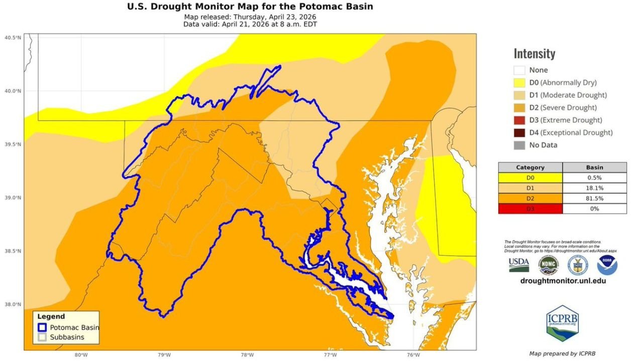
The Scale of the Drought Across the Potomac Watershed
The U.S. Drought Monitor map for the Potomac Basin released April 23, 2026 shows the drought coverage across the watershed in stark terms. The basin breakdown by category is unambiguous:
- D2 Severe Drought — 81.5% of the basin — the dominant drought classification across the Potomac watershed, covering the vast majority of the river’s drainage area from its headwaters in West Virginia through Maryland, Virginia and into the Washington D.C. metro
- D1 Moderate Drought — 18.1% of the basin — the lighter orange shading across the northern and eastern edges of the watershed
- D0 Abnormally Dry — 0.5% of the basin — a negligible fraction on the outer edge of the drought footprint
- D3 Extreme Drought — 0% — not yet present in the basin, but the record low river flow suggests conditions may be approaching that threshold in the most severely affected subbasins
The Interstate Commission on the Potomac River Basin — the ICPRB, the regional authority responsible for coordinating Potomac water management across five jurisdictions — has confirmed nearly 82 percent of the Potomac watershed is under Severe Drought in its latest report. That figure covers an enormous geographic area from the Allegheny highlands of West Virginia through the Shenandoah Valley and into the tidal Potomac near Washington D.C.
What the Record Low River Flow Means
A 3,460 cubic feet per second flow at Point of Rocks is not just a statistical record — it has practical consequences for the Washington D.C. region’s water supply infrastructure and ecological health that extend well beyond the number itself.
The Potomac River is the primary drinking water source for approximately 5 million people across the Washington D.C. metropolitan area, served by water intakes operated by the Washington Aqueduct and associated utilities in Maryland and Virginia. While current flow levels remain above the thresholds that trigger emergency water supply protocols, a 131-year record low in late April — before summer’s peak demand and before the historically dry July and August months — creates a concerning baseline heading into the warmer season.
The ecological consequences are immediate and visible:
- Stream flows across Potomac tributaries — the Shenandoah, Monocacy, Cacapon and Conococheague among them — are running at critically low levels, stressing cold-water fisheries including trout populations that require specific temperature and flow conditions
- Groundwater recharge across the watershed has been minimal since last summer, meaning wells across rural Virginia, Maryland and West Virginia are running lower than seasonal averages
- Reservoir storage in the regional system, while still providing a buffer, is drawing down faster than normal because the river is not replenishing withdrawals at typical rates
Wednesday Rain — A Start, Not a Solution
Wednesday’s frontal rain system is expected to deliver 0.5 to 1.0 inches across the Washington D.C. region — meaningful for parched soils and a contribution to stream flow recovery, but far short of what is needed to close the deficit that has been building since last summer.
The ICPRB framing is appropriate: Wednesday’s rain can’t come soon enough and is genuinely welcome, but it will not end the Severe Drought designation across the basin. Closing an 81.5% Severe Drought footprint requires not one rain event but a sustained period of above-normal precipitation measured in weeks rather than days. A single inch of rain on a watershed running this dry disappears quickly into soil moisture deficit before meaningful stream flow recovery occurs.
What the ICPRB Is Asking Residents to Do
The Interstate Commission on the Potomac River Basin is actively urging water conservation across the region. Specific actions flagged in the latest ICPRB newsletter include:
- Take shorter showers — reducing indoor hot water use is one of the highest-impact individual conservation actions
- Run laundry and dishwashers only with full loads — eliminating partial-load cycles reduces water consumption without changing household routines significantly
- Turn the tap off when not actively in use — while running water, brushing teeth or washing dishes
These are not emergency rationing measures — they are precautionary conservation actions appropriate for a region where 82% of the watershed is under Severe Drought and the main river is at a 131-year record low in late April.
Cities and Areas Across the Drought-Affected Watershed
- Washington, D.C. — primary population center dependent on Potomac water supply
- Bethesda and Silver Spring, Maryland — Montgomery County communities served by Washington Aqueduct intakes
- Alexandria and Arlington, Virginia — Northern Virginia communities drawing from the Potomac system
- Frederick, Maryland — upper Potomac watershed, Monocacy River tributary system
- Martinsburg, West Virginia — upper watershed headwater region under Severe Drought
- Winchester, Virginia — Shenandoah Valley, major Potomac tributary watershed
WaldronNews.com will continue tracking drought conditions across the Potomac watershed and provide updates on river flow recovery, rainfall contributions and water supply status as Wednesday’s frontal system delivers the region’s most significant rain in weeks.