
Dallas, Fort Worth and Denton Face Urgent Life and Property Threat as 3.5 Inch Giant Hail Moves Directly Over the MetroPlex With Tornado Watch Until 9 PM
DALLAS, Texas — North Texas is facing a significant life and property threat over the next few hours. Giant, destructive hail is moving directly over the Dallas-Fort Worth MetroPlex right now, and the window for the most intense activity runs from 3:00 PM through 7:00 PM. Every vehicle still outside needs to be under sturdy cover immediately. Every resident needs to be indoors and away from windows. This is not a watch-and-wait situation.
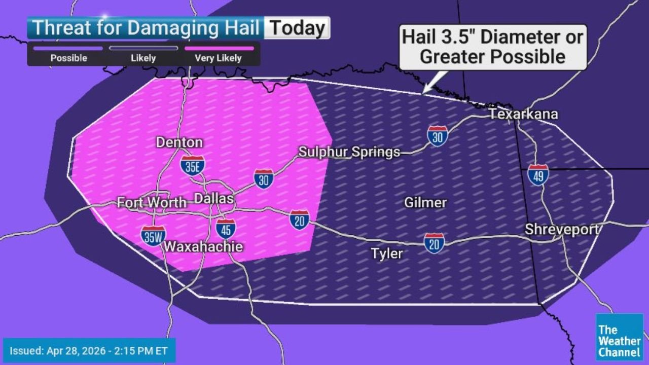
The Hail Threat — Very Likely, Moving Directly Over DFW
The damaging hail threat map issued at 2:15 PM Eastern April 28 places the Dallas, Fort Worth, Denton and Waxahachie corridor inside the Very Likely zone for hail at 3.5 inches in diameter or greater. A stone at 3.5 inches is larger than a baseball and approaching softball size. At that diameter:
- Windshields shatter on direct impact
- Vehicle hoods, roofs and trunks sustain dents requiring full panel replacement
- Roofing materials are penetrated or destroyed across entire neighborhoods simultaneously
- Anyone outdoors faces a genuine physical injury risk from direct stone impact
The Very Likely pink zone covers the core DFW metro including Fort Worth, Dallas, Denton and Waxahachie. The broader 3.5 inch or greater possible zone extends eastward through Sulphur Springs, Gilmer, Tyler and Shreveport, meaning the giant hail threat does not end at the metroplex edge.
The Tornado and Wind Threat
While hail is the primary and most certain hazard today, a Tornado Watch is in effect until 9:00 PM CDT across the region. The TORCON Index values confirm an active tornado environment alongside the hail threat:
- TORCON 3 for Dallas and Fort Worth — a 30% probability of a tornado within 50 miles
- TORCON 4 for areas just east of Dallas toward Sulphur Springs and the Arklatex corridor, indicating a 40% tornado probability
The severe thunderstorm map shows Very Likely severe thunderstorms across the Dallas and Wichita Falls corridor, with Likely severe thunderstorms extending through Oklahoma City, Fort Smith, Little Rock, Texarkana and Shreveport, and Possible severe thunderstorms reaching through the broader Mid-South into Nashville, Huntsville, Birmingham and Tupelo.
The 3 PM to 7 PM Window — When to Be Inside
The most intense activity is concentrated in the 3:00 PM to 7:00 PM window. This is the peak supercell development period when storms have maximum access to afternoon instability and when the organized hail-producing updrafts are strongest. After 7:00 PM, storm mode is expected to trend toward upscale growth and the giant hail threat gradually decreases as supercells merge into a line.
Every minute between now and 3 PM is time to complete protective actions before the threat arrives.
Cities in Each Threat Zone
Very Likely giant hail zone:
- Dallas, Texas
- Fort Worth, Texas
- Denton, Texas
- Waxahachie, Texas
- Plano, Texas
3.5 inch or greater hail possible zone:
- Sulphur Springs, Texas
- Gilmer, Texas
- Tyler, Texas
- Shreveport, Louisiana
- Texarkana, Texas and Arkansas
TORCON 4 tornado corridor:
- Little Rock, Arkansas
- Texarkana, Texas and Arkansas
- Greenville, Mississippi
- Fort Smith, Arkansas
Four Actions to Take Right Now
- Move all vehicles under sturdy covered parking immediately — a garage, parking structure or solid carport. Hail at 3.5 inches causes total-loss vehicle damage in seconds and there is no warning once the storm core arrives
- Stay indoors and away from all windows — giant hail can shatter standard window glass. Interior rooms on the lowest floor are the safest position during the hail threat
- Charge your phone and confirm weather alerts are turned on — the 3 PM to 7 PM window spans the commute hours when many residents will be away from home and need reliable alert reception
- Identify your safe spot for a tornado warning now — the lowest floor interior room away from all windows. If a tornado warning is issued for your county, move there immediately without waiting
WaldronNews.com will continue tracking the severe weather emergency across the Dallas-Fort Worth MetroPlex and provide real-time updates on hail reports, tornado warnings and storm movement through 9 PM.