
Dallas, Fort Worth, Plano and Denton Upgraded to Level 4 Moderate Risk as Giant Hail From Intense Supercells Now Expected Across the MetroPlex
DALLAS, Texas — The Storm Prediction Center has issued a Level 4 out of 5 Moderate Risk upgrade for the Dallas-Fort Worth MetroPlex and surrounding communities, driven by higher confidence in very large to giant hail from intense supercells expected to develop across the region today. The upgrade reflects a forecast that has moved beyond possibility into expectation — intense supercells are anticipated, and where they track, giant hail is the primary and high-confidence hazard.
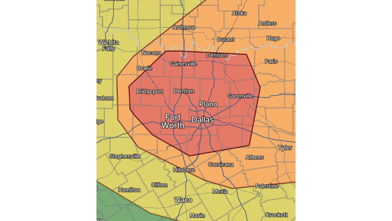
The Upgraded Risk Zone — What Each Area Faces
The risk map shows two concentric zones centered directly over the DFW metro:
Dark Red Core — Highest Concentration of Giant Hail Risk: The innermost zone covers the heart of the metroplex including Fort Worth, Dallas, Plano, Denton, Bridgeport, Gainesville, Denison and Greenville. This is where intense supercells are most likely to track and where the highest probability of giant hail is concentrated. Giant hail is defined as stones 2 inches or larger in diameter, and the most intense supercells in this environment have the potential to produce stones reaching baseball to softball size depending on updraft strength and storm longevity.
Orange Enhanced Risk — Surrounding Metro Communities: The broader orange zone extends from Ardmore and Durant in Oklahoma southward through Nocona, Bowie and Bridgeport on the west and Paris and Hugo on the east, reaching south through Corsicana, Hillsboro and Waco. This zone carries elevated severe weather risk with large hail and damaging winds as the primary threats as supercells potentially interact with each other and grow upscale through the afternoon.
Yellow Slight Risk — Outer Boundary: The outer yellow zone reaches from Wichita Falls through the broader north Texas and southern Oklahoma corridor, where isolated severe storms remain possible but with lower probability than the core zones.
Why the Moderate Risk Upgrade Was Issued
The upgrade from Enhanced to Moderate Risk is not a routine adjustment. It signals that forecasters have reached higher confidence in a specific, high-end hazard across a defined area. The trigger for today’s upgrade is the increasing certainty around two factors:
Intense supercell development is expected. The atmospheric ingredients across the DFW corridor today support supercells operating near the upper end of their organizational potential. Strong deep-layer shear supports long-lived, organized rotating storms. Extreme instability with CAPE values in the 4000 to 6000 J/kg range drives updrafts powerful enough to loft and grow very large hailstones. The combination of these two ingredients in the same location at the same time is what produces the most destructive hail events.
Giant hail production is thermodynamically favored. The Hail Growth Zone, the layer of atmosphere between 0°C and minus-20°C where hailstones accumulate ice most efficiently, is loaded with CAPE today. Steep lapse rates through both the low and mid-levels accelerate updraft development through this zone. Dry air aloft enhances hailstone growth by causing supercooled water droplets to rime onto growing stones with additional ice layers. Every thermodynamic factor that forecasters look for in a giant hail environment is present today across the DFW corridor.
What Giant Hail Does to the MetroPlex
A supercell producing baseball to softball-sized hail tracking through a densely populated metro area like Dallas-Fort Worth creates catastrophic and immediate property damage across a wide swath:
- Vehicle damage is total-loss level in the core of a giant hail shaft. Stones at 3 to 4 inches shatter windshields, dent hoods and roofs beyond repair and destroy convertible tops in seconds
- Roof damage across residential and commercial structures is severe, with stones large enough to penetrate roofing materials, crack skylights and break solar panels
- Windows and glass facades on commercial buildings are at risk from direct hail impact
- Outdoor equipment, HVAC systems and vehicles left unsheltered face destruction with no warning once the storm core arrives
Cities Inside the Highest Risk Zone
Dark red core zone:
- Dallas, Texas
- Fort Worth, Texas
- Plano, Texas
- Denton, Texas
- Gainesville, Texas
- Denison, Texas
- Greenville, Texas
- Bridgeport, Texas
- Corsicana, Texas
Orange Enhanced Risk zone:
- Ardmore, Oklahoma
- Durant, Oklahoma
- Paris, Texas
- Waco, Texas
- Hillsboro, Texas
- Athens, Texas
- Nocona, Texas
What Every MetroPlex Resident Must Do Right Now
- Get all vehicles inside a garage or under a covered structure immediately — this is not a suggestion at the Moderate Risk level with giant hail expected. A vehicle left outside in the path of a softball-sized hail shaft is a total-loss vehicle. There is no recovering that decision after the storm passes
- Do not be on the highway between 3 and 7 PM across the DFW metro if any alternative exists. Commuters caught on exposed roadways during a giant hail event face windshield failure, vehicle damage and physical danger if forced to exit a vehicle
- If caught outside when hail begins, get inside a sturdy structure immediately — do not stay in a vehicle as a first choice if a building is accessible
- Watch for severe thunderstorm warnings specifically noting hail size as storms initiate this afternoon — any warning mentioning hail at 2 inches or larger for your county is a signal to be inside and protected
- An isolated tornado remains possible alongside the giant hail threat — shelter plans should account for both hazards
WaldronNews.com will continue tracking the Moderate Risk upgrade and supercell development across the Dallas-Fort Worth MetroPlex and provide real-time updates on hail reports, tornado warnings and storm progression through the afternoon and evening.