
Dodge City and Clovis Farmers Warned That National Blend Model Is Overdoing Rainfall as High Plains Precipitation Gradient Poorly Resolved Through Saturday
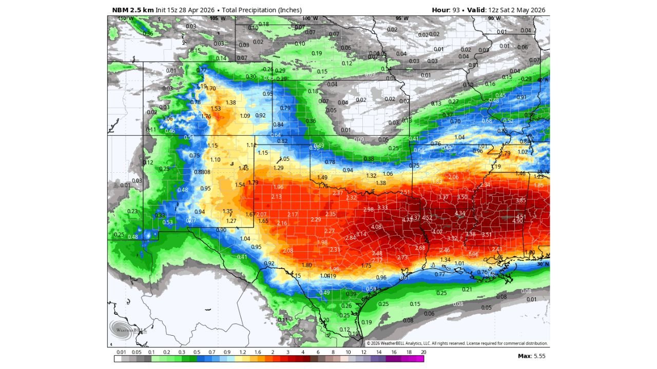
DODGE CITY, Kansas — A critical forecast accuracy warning is being issued for farmers and ranchers across the west and southwest High Plains. The National Blend of Models total liquid precipitation forecast through Saturday morning is significantly overdoing rainfall amounts across a broad area from Dodge City, Kansas westward toward Clovis, New Mexico, and the precipitation gradient from northeast to southwest is not nearly sharp enough in the model output. Some locations will see meaningful rain. Many will not. The difference between those two outcomes is not being captured accurately in the graphic that has been widely circulated.
What the NBM Is Showing and Why It Is Wrong
The NBM 2.5km forecast initialized April 28 at 15Z, valid through 12Z Saturday May 2 shows the total precipitation footprint across the central and southern United States through the end of the week. The model output displays a broad swath of orange and red shading across the southern Plains and into Texas, with values suggesting 1.5 to 2.5 inches across a wide corridor from southwest Kansas through the Oklahoma and Texas Panhandles and into eastern New Mexico.
The problem is the west and southwest High Plains coverage. The model is painting rainfall across this region with too broad a brush. The actual precipitation gradient, which should drop off much more sharply from northeast to southwest across the area between Dodge City and Clovis, is being smeared across a wider area than will actually receive meaningful rain. This is a known limitation of blended model products in regions where convective rainfall is spotty and highly variable.
The honest forecast reality for this corridor: some locations will jackpot with meaningful rainfall while many others in the same general region will see little to nothing. The NBM graphic does not adequately communicate that variability.
Where the Model Is More Reliable
The eastern portions of the forecast map, covering the southern Plains from central Oklahoma and Kansas eastward through Arkansas, Missouri and into the Mid-South, show a more confident and better-resolved precipitation signal. The deep red shading across eastern Oklahoma, Arkansas and into the lower Mississippi Valley, with values of 3.0 to 4.5 inches, reflects a higher-confidence rainfall event tied to the active frontal and convective pattern tracking through those states through the weekend.
Specific values on the map that carry more forecast confidence:
- Eastern Oklahoma and Arkansas corridor — 2.50 to 4.52 inches through Saturday morning
- Missouri and the lower Mississippi Valley — 3.37 to 4.34 inches across the heaviest zones
- Central Texas and the Arklatex — 1.75 to 3.14 inches with more confidence than the High Plains corridor
- Northern New Mexico and southern Colorado — 0.53 to 1.76 inches in isolated higher totals, but with the same high variability warning applying here as to the broader High Plains
The Dodge City to Clovis Corridor — Treat With Caution
The area specifically flagged for forecast caution runs from Dodge City, Kansas westward and southwestward through the Oklahoma and Texas Panhandles toward Clovis, New Mexico. This is the desert farming and ranching belt where water management decisions depend on accurate precipitation forecasts and where a forecast bust has direct agricultural and operational consequences.
Ranchers and farmers in this corridor making decisions based on the NBM graphic should understand:
- The model is likely overstating coverage across the High Plains portion of the forecast area
- The precipitation gradient is too gradual in the model output, meaning areas that should show near-zero rainfall are being assigned 0.5 to 1.5 inches of precipitation that is unlikely to verify
- Isolated convective storms may produce locally heavy rainfall in some spots while leaving nearby areas completely dry, a variability pattern that blended model output cannot resolve
- Irrigation scheduling, fieldwork planning and water storage decisions should not be made based on the NBM totals for the Dodge City to Clovis corridor without consulting higher-resolution local forecast guidance
What to Watch Instead
For the High Plains agricultural community from Dodge City through the Texas and Oklahoma Panhandles to Clovis:
- Monitor local NWS forecast discussions from the Dodge City, Amarillo and Albuquerque forecast offices, which will provide more granular guidance on convective coverage and storm placement than blended model graphics
- Watch short-range radar trends through Thursday and Friday for where convective initiation actually occurs, as that will be the best real-time indicator of where rainfall jackpots and where it misses
- Treat the NBM graphic as a general pattern indicator showing that some rain is possible across the region, not as a reliable field-by-field or county-by-county precipitation forecast
WaldronNews.com will continue tracking precipitation forecasts across the High Plains and southern Plains through Saturday and provide updates on rainfall totals and agricultural weather impacts as the pattern evolves.