
Orlando, Tampa and Miami Face a Two-Day Weather Threat With Dangerous Fire Conditions Saturday and Strong to Very Strong Storms Possible Sunday
ORLANDO, Florida — A long and weather-active weekend is taking shape across the Florida Peninsula after weeks of a simple, locked-in pattern. Two distinct and very different threats arrive back to back. Saturday brings dangerous fire weather as strong winds and dry air ahead of an approaching front create conditions that could allow fires to spread rapidly across the state. Sunday brings the front itself, delivering much-needed rain alongside the threat of strong to very strong storms for the entire peninsula. This is a weekend to be weather aware across all of Florida.
Saturday — Dangerous Fire Weather Day
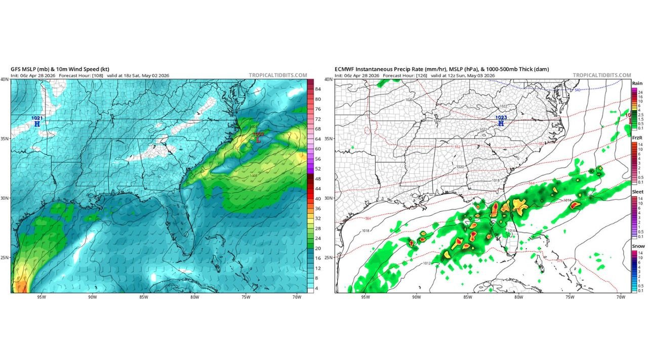
The GFS MSLP and 10-meter wind speed forecast valid Saturday May 2 at 18Z shows the atmospheric setup driving the Saturday fire weather concern. A 1002 millibar low pressure system positioned off the Carolina coast is tightening the pressure gradient across Florida, driving strong onshore and southerly winds across the Gulf side of the state. The green shading on the wind speed map, indicating winds of 30 to 40 knots across portions of the Gulf of Mexico and the western Florida coast, confirms that Saturday will be a genuinely windy day across much of the peninsula.
The combination driving the fire weather threat:
- Strong winds accelerating fire spread rates and carrying embers ahead of any active fire
- Dry air ahead of the front that has not yet delivered its moisture to Florida’s parched landscape
- Low relative humidity expected through the afternoon hours before frontal moisture begins arriving
- Vegetation across Florida that has been moisture-stressed after weeks of below-normal rainfall and developing drought conditions statewide
Florida has been locked into a simple, dry weather pattern for weeks. That extended dry stretch means grasses, brush and understory vegetation are primed as fuel. Saturday’s wind and dry air combination arriving on top of drought-stressed vegetation is the definition of a dangerous fire weather day.
Sunday — The Front Arrives With Rain and Storm Threat
The ECMWF instantaneous precipitation rate valid Sunday May 3 at 12Z shows the frontal rainfall and storm complex pushing across the Florida Peninsula by Sunday morning. The orange and red cores embedded within the broader green precipitation shield indicate intense convective rainfall rates of 6 to 16 mm per hour or greater at multiple locations across the Gulf Coast and into the southern peninsula, with the storm line tracking from west to east across Florida through the day.
The frontal passage brings:
- Much-needed rainfall across the entire peninsula, with the heaviest totals concentrated along and behind the frontal boundary pushing southward
- Strong to very strong storms possible for the entire Florida Peninsula as the front interacts with Gulf moisture and whatever instability remains available after Saturday’s wind and mixing erode the boundary layer
- The most intense convective cores visible on the ECMWF output suggest locally heavy rainfall rates capable of producing brief street flooding in urban areas
- The storm threat is described as strong to very strong rather than severe outbreak language, meaning organized damaging winds and heavy rainfall are the primary concerns rather than tornadoes
The Two-Day Threat Timeline
Saturday May 2:
- Strong south to southwest winds developing through the morning and afternoon
- Dry air and low relative humidity through peak afternoon hours
- Dangerous fire weather conditions statewide, particularly across the I-4 corridor and central Florida where drought conditions are most developed
- Frontal moisture beginning to approach from the west by evening
Sunday May 3:
- Frontal passage bringing rain and storms tracking southward across the peninsula
- Strong to very strong storms possible for all of Florida from the Panhandle through Miami
- Heavy rainfall rates embedded in the stronger convective cells
- Conditions improving behind the frontal passage from north to south through the day
Cities Facing Both Threats This Weekend
Saturday fire weather concern:
- Orlando, Florida
- Tampa, Florida
- Gainesville, Florida
- Ocala, Florida
- Lakeland, Florida
- Tallahassee, Florida
Sunday storm threat:
- Jacksonville, Florida
- Gainesville, Florida
- Orlando, Florida
- Tampa, Florida
- Fort Myers, Florida
- Miami, Florida
- West Palm Beach, Florida
What Florida Residents Need to Do This Weekend
- Saturday — avoid any outdoor burning or activity that could spark a fire. Report any smoke or fire to local emergency services immediately. Strong winds can push a grass fire across roads and into communities faster than residents can evacuate without warning
- Sunday — have weather alerts active before the front arrives. The strong to very strong storm threat applies to the entire peninsula, meaning no part of Florida is outside the weekend weather concern
- The beneficial rain on Sunday is genuinely welcome after weeks of dry conditions and developing drought, but residents should not let the positive rainfall story reduce awareness of the storm threat embedded within the frontal passage
WaldronNews.com will continue tracking Florida’s weekend weather pattern and provide updates on fire weather conditions Saturday and storm timing and severity Sunday as the front approaches.