
Springfield, Missouri Supercell Displays Textbook Structure as 19.5-Degree Radar Tilt Reveals Perfect Mesocyclone Lofting Precipitation to 26,000 Feet
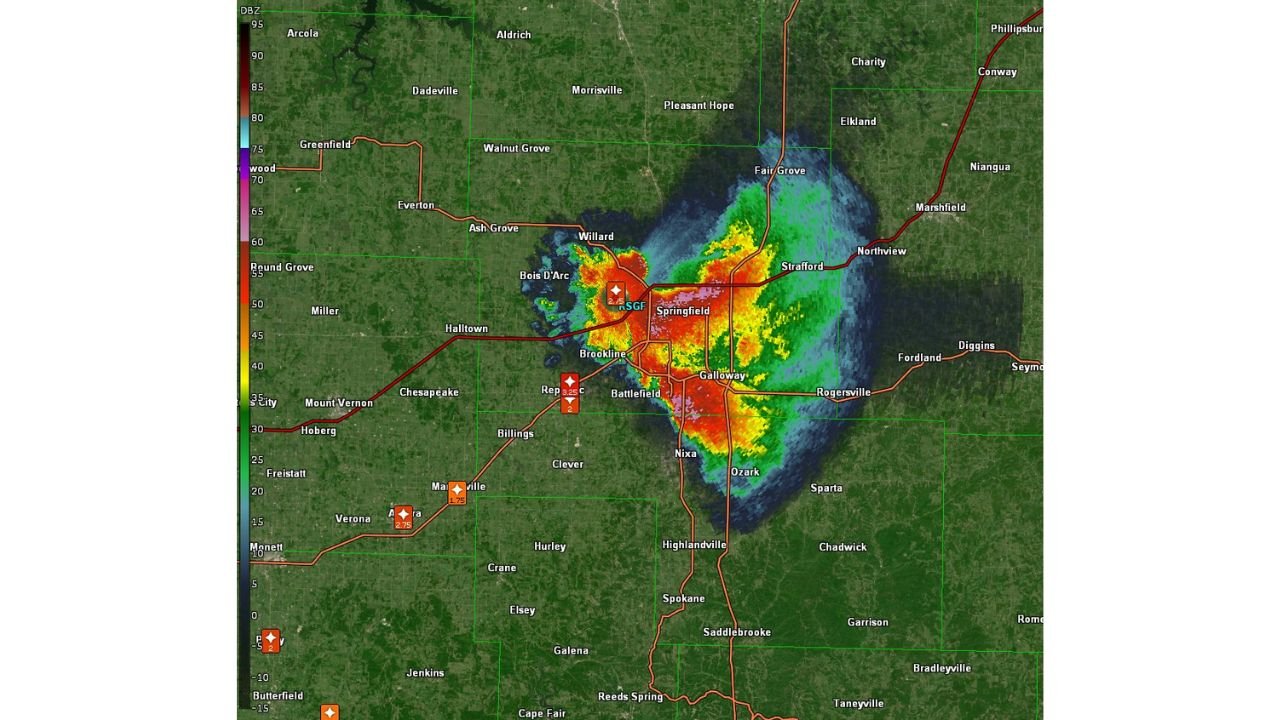
SPRINGFIELD, Missouri — A textbook severe thunderstorm is producing one of the most visually striking radar signatures of the entire outbreak over Springfield, Missouri tonight. The KSGF radar at a 19.5-degree tilt — a very high elevation angle looking from approximately 3,000 feet up to 26,000 feet at the edge of the heavier precipitation — is revealing a perfect supercell structure shaped by a strong mid-level mesocyclone. Precipitation paths are visible with extraordinary clarity as lofted hydrometeors trace the exact circulation of the rotating updraft above the Springfield metro.
What the 19.5-Degree Tilt Is Showing
Standard radar analysis of severe thunderstorms uses low-elevation tilts — typically 0.5 to 1.5 degrees — to examine the storm’s structure near the ground where tornadoes and surface winds are most relevant. The 19.5-degree tilt used in this image is examining the storm at a fundamentally different level. At that elevation angle scanning from the KSGF radar site, the beam is cutting through the mid-to-upper levels of the supercell — the region where the mesocyclone is most organized and where precipitation is being lofted by the powerful rotating updraft.
What makes this image exceptional is the ability to exactly trace precipitation paths as hydrometeors — rain, hail and ice particles — are carried by the updraft and deposited around the storm’s circulation. The curvature of the precipitation field around the mesocyclone center is not a radar artifact. It is the physical signature of a rotating column of air carrying precipitation in a tight, organized spiral — the visual proof of a strong mid-level mesocyclone in full operation over Springfield.
Reading the Radar Image
The KSGF high-tilt radar image over the Springfield metro shows several distinct features that meteorologists use to identify strong supercell structure:
- The intense red and orange core directly over and immediately west of Springfield — reflectivity values in the 70 to 80+ dBZ range indicating the heaviest precipitation and hail concentration within the storm’s updraft and forward flank regions. Values above 75 dBZ in a supercell are associated with very large hail being lofted and suspended within the rotating updraft
- The dark blue notch on the western and southwestern edge of the storm — this is the bounded weak echo region (BWER), one of the most important structural features in a severe supercell. The BWER forms where the powerful updraft is pulling surface air upward so forcefully that precipitation cannot fall into that zone — it is literally the radar signature of an updraft so strong it creates a precipitation-free notch in the storm’s base. A well-defined BWER at a high radar tilt confirms an extremely vigorous rotating updraft
- The green and yellow precipitation shield wrapping around the eastern and northeastern side of the storm — this is the forward flank precipitation region, where hail and heavy rain are being deposited downwind of the updraft as the mesocyclone carries hydrometeors through the storm’s circulation
- The precipitation-free area to the north and northwest of the core — the region where the high-tilt beam is looking above the storm’s precipitation field, confirming the storm’s limited upward extent at the outermost edges versus its extreme vertical development at the core
Why the 19.5-Degree Tilt Matters for Storm Analysis
Using a 19.5-degree elevation tilt to examine a supercell provides information that low-level radar scans cannot. At this angle over a storm at close range to the KSGF radar:
- Meteorologists can see the mesocyclone’s three-dimensional structure rather than just its surface-level signature
- Hail trajectories become visible as lofted ice particles trace the circulation paths within the rotating updraft
- The updraft tilt — how much the storm leans with height — is directly measurable, with a more upright updraft generally supporting stronger, more organized rotation
- Bounded weak echo region depth can be assessed, giving a direct measure of updraft strength — a deeper BWER indicates a more powerful updraft capable of suspending larger hailstones for longer periods
The 19.5-degree tilt classification as very high means this scan is cutting through air that was at the surface level 15 to 20 minutes ago — the meteorological equivalent of an X-ray showing the internal machinery of the storm rather than just its surface presentation.
What This Storm Structure Means for the Springfield Metro
A supercell displaying textbook structure with a strong mid-level mesocyclone visible at high radar tilts is a storm operating near its maximum organizational potential. The Springfield metro and surrounding communities including Battlefield, Nixa, Ozark, Galloway and Rogersville are directly beneath or immediately downwind of a storm that is:
- Capable of producing and sustaining very large hail within its lofted precipitation cores
- Organized sufficiently to support tornado development if low-level rotation tightens beneath the mid-level mesocyclone
- Likely to maintain its supercell character for an extended period given the visible updraft strength
Residents across the Springfield corridor should treat any tornado warning or severe thunderstorm warning issued for this storm as an immediate shelter signal — a supercell displaying this level of structural organization at high radar tilts has the capacity to produce all severe hazards with limited additional warning time.
WaldronNews.com will continue tracking the Springfield supercell and provide immediate updates on tornado warnings, hail reports and storm progression as this system moves through the Ozarks region.