
Bismarck and Minneapolis Farmers Get Best Early May Planting Windows While Chicago, Indianapolis and Cleveland Face Limited Dry Time Through Mid-May
BISMARCK, North Dakota — The early to mid-May planting outlook is delivering a clear divide across the central United States, and the split between agricultural haves and have-nots is sharp. Farmers across the Northern Plains are looking at the best dry windows of the spring planting season, with conditions expected to run much below normal on precipitation and opportunities for 3-plus day dry stretches that allow consistent fieldwork. Meanwhile, producers across the Ohio Valley and Great Lakes will find extended dry time harder to come by as a more active pattern with frequent light to moderate rain risks limits workable days through mid-May.
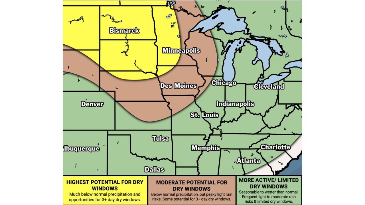
The Three Zones — What Each Region Faces
Highest Potential for Dry Windows — Yellow Zone: The yellow zone covering North Dakota, South Dakota, Minnesota and the northwestern Corn Belt represents the most favorable planting weather window in the country for early to mid-May. This zone is expected to run much below normal on precipitation with genuine opportunities for 3 or more consecutive dry days that allow producers to run equipment continuously without weather interruptions. Bismarck, Fargo, Pierre and Minneapolis sit inside this zone, and farmers in these areas should be positioned to make aggressive planting progress during this window.
The yellow zone also extends into portions of Montana, Wyoming and the western Dakotas, though soil temperatures in the northernmost and highest-elevation portions of this zone may still be limiting for optimal corn germination even with dry conditions present.
Moderate Potential for Dry Windows — Brown Zone: The brown transitional zone covers Iowa, Nebraska, Kansas, Missouri and portions of Colorado and Wyoming. This zone is forecast to run below normal on precipitation but with pesky light rain risks embedded in the pattern that can interrupt fieldwork even when the overall trend is drier than normal. Three-plus day dry windows are possible in this zone but not guaranteed, and producers should watch short-range forecasts closely to identify and capitalize on workable stretches as they open up.
Des Moines, Omaha, Kansas City and Denver sit inside this moderate zone. The pattern is not hostile to planting progress but requires more active forecast monitoring than the favorable northern zone.
More Active and Limited Dry Windows — Green Zone: The green zone covering the Ohio Valley, Great Lakes, Mid-South and Southeast faces the most challenging planting weather pattern of the three regions. Precipitation is expected to run seasonable to wetter than normal with frequent light to moderate rain risks that limit the number of consecutive dry days available for fieldwork. Chicago, Indianapolis, Cleveland, St. Louis, Memphis, Atlanta and Charlotte all sit inside this zone.
For corn and soybean producers in Illinois, Indiana, Ohio and Kentucky, this outlook reinforces what has been a difficult late April and early May. Extended wet periods in these states delay planting past the agronomically optimal window and increase the yield drag associated with late-planted corn.
Why the Pattern Creates Haves and Have-Nots
The atmospheric pattern driving this divide through early to mid-May is the same cold trough over the Great Lakes and Ohio Valley that has dominated the eastern half of the country since late April. The trough keeps storm systems tracking through the Great Lakes corridor repeatedly, delivering frequent light rain events to Illinois, Indiana and Ohio while simultaneously allowing the Northern Plains to sit under drier high pressure on the western side of the pattern.
This is a classic split-pattern agricultural setup where:
- Northern Plains producers benefit from the drier western side of the trough
- Ohio Valley and Great Lakes producers sit directly under the active storm track on the eastern side
- The transitional brown zone across Iowa and Nebraska sits in the gradient between the two regimes, experiencing elements of both
Planting Calendar Implications
May is the critical month for corn planting across the northern Corn Belt. Agronomists generally cite May 1 through May 15 as the optimal planting window for maximum yield potential across the northern tier, with yield drag increasing after that point. The pattern implications by region:
- Northern Plains — the dry window outlook supports planting progress during the optimal calendar window. Producers should be ready to move aggressively when conditions allow
- Iowa and Nebraska — the moderate zone suggests some progress is possible but producers should expect interruptions and plan accordingly
- Illinois, Indiana and Ohio — the limited dry window outlook raises the probability of delayed planting across a significant portion of the eastern Corn Belt, with potential yield impacts if the active pattern persists past mid-May
Cities in Each Zone
Highest potential for dry windows:
- Bismarck, North Dakota
- Fargo, North Dakota
- Pierre, South Dakota
- Sioux Falls, South Dakota
- Minneapolis, Minnesota
Moderate potential for dry windows:
- Des Moines, Iowa
- Omaha, Nebraska
- Kansas City, Missouri
- Denver, Colorado
- Tulsa, Oklahoma
Limited dry windows and active pattern:
- Chicago, Illinois
- Indianapolis, Indiana
- Cleveland, Ohio
- St. Louis, Missouri
- Memphis, Tennessee
- Atlanta, Georgia
WaldronNews.com will continue tracking the early May agricultural weather pattern across the central United States and provide updates on planting progress, dry window timing and rainfall totals as the pattern evolves through mid-May.