
Cresson, Texas Tornado Deviated Southwest Toward Texas 171 Catching Storm Chasers Off Guard as Velocity Couplet Confirmed Tight Rotation at 6:18 PM
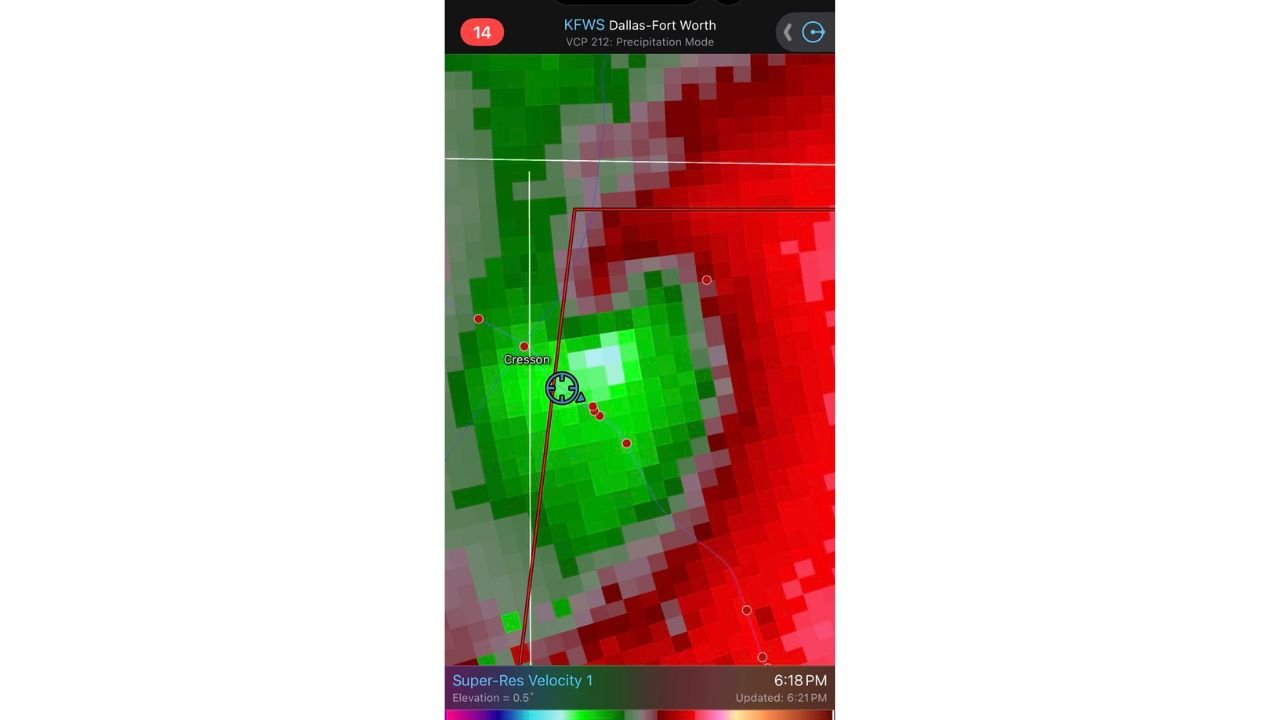
CRESSON, Texas — One of the more dangerous and disorienting moments from Tuesday’s severe weather outbreak in north Texas unfolded south of Cresson when a tornado formed in an unexpected location, tracked northeast behind a storm chaser’s position, then deviated sharply southwest toward Texas 171 — moving directly back toward the highway and the observer who had already repositioned ahead of it. The velocity couplet captured on the KFWS Dallas-Fort Worth radar at 6:18 PM confirms the tight, well-defined rotation that produced this tornado directly over the Cresson area, with the mesocyclone marker centered on the storm’s circulation as it made its unexpected southwest deviant track.
How the Tornado Caught the Observer Off Guard
The sequence of events south of Cresson is a textbook example of why deviant tornado motion is one of the most dangerous phenomena in storm chasing and in residential severe weather awareness. The observer initially anticipated tornado formation to the southeast where visibility was clearer and storm structure was more obvious. Instead, the tornado formed to the northeast, behind the observer’s position, in an area that was obscured and not the focus of visual attention.
The storm then executed a classic deviant move. Rather than continuing on a northeast track consistent with the mean wind flow, it turned south and then deviated southwest toward Texas 171, reversing toward the observer’s location and the highway. The moment the tornado’s right edge began to clip the observer’s position, winds drastically increased and power went out before the tornado became visible to the east.
This scenario illustrates several critical points about tornado behavior that apply to anyone in a severe weather zone:
- Tornadoes do not always track northeast. In environments with splitting supercells or complex boundary interactions, deviant motion to the south or southwest is possible and can reverse a storm’s track toward positions that appeared safe minutes earlier
- Rain-wrapping and reduced visibility can conceal a tornado until it is dangerously close. The observer did not see the tornado until it was directly to the east after winds had already increased dramatically
- HP supercell environments in particular, like Tuesday’s DFW setup, produce rain-wrapped tornadoes that cannot be seen until proximity is already dangerous
What the Radar Shows
The KFWS Super-Resolution Velocity radar at 6:18 PM, 0.5 degree elevation shows the storm’s rotation signature with clarity. The green inbound velocity on the west side and the deep red outbound velocity on the east side form a tight velocity couplet centered directly over and south of Cresson, with the mesocyclone symbol marking the center of rotation.
The couplet is well-defined and compact, indicating a concentrated, organized mesocyclone rather than diffuse rotation spread over a large area. Compact, tight couplets are associated with the most intense tornadoes because the rotational energy is concentrated into a smaller area, increasing wind speeds within the circulation. The red dot markers south of the mesocyclone symbol indicate the reported tornado path at this time.
The tornado warning polygon visible on the radar image extends southward from Cresson along the storm’s motion path, correctly capturing the southwest deviant track that made this tornado so dangerous for anyone positioned along or south of Texas 171.
Why Southwest Deviant Motion Happens
The southwest deviant track observed with this Cresson tornado is consistent with a left-split supercell or a right-mover that has undergone a track deviation driven by boundary interactions or storm-scale dynamics. In Tuesday’s DFW environment, the parallel bulk shear and splitting supercell character meant that storm motion was not uniform across all cells. When a storm’s mesocyclone interacts with an outflow boundary or a localized wind shift, the track can change rapidly in ways that are difficult to anticipate even for experienced observers using real-time radar.
The southwest deviant motion is particularly dangerous because:
- Observers and residents who have positioned north or northeast of a storm to stay ahead of it suddenly find the storm tracking toward them
- Standard tornado warning polygons are drawn based on the storm’s primary motion vector and may not fully capture the deviant track until radar updates confirm the new direction
- The transition from safe positioning to dangerous proximity can happen in 2 to 4 minutes with a fast-moving deviant tornado
What This Event Means for Residents in Severe Weather Zones
The Cresson tornado is a direct reminder that there is no safe outdoor position during an active tornado warning. The assumption that being north or northeast of a storm guarantees safety fails in deviant motion scenarios. The only reliably safe position during a tornado warning is inside a sturdy structure in an interior room on the lowest floor away from all windows.
For anyone in a vehicle during a tornado warning, the Cresson sequence also confirms that vehicle positioning relative to a tornado can change faster than the ability to drive away. A tornado that appears to be moving away can deviate toward your position without warning.
WaldronNews.com will continue reviewing storm reports and tornado tracks from Tuesday’s north Texas severe weather event and provide updates on damage surveys and confirmed tornado paths as post-event assessments are completed.