
North and West Florida Face Tornado and Severe Storm Risk Saturday as Atmospheric Analogs Highlight 60% Probability Across the Panhandle
TALLAHASSEE, Florida — North and west Florida are facing a credible severe storm threat this Saturday, with atmospheric analog analysis placing the highest severe weather probability at 60% across the Panhandle and northern portions of the state where stronger instability and wind shear are both present. Three historical analog dates — April 1, 2020, March 31, 2011, and April 8, 2018 — show a solid match to the current atmospheric setup, with the 2011 event likely being a stronger analog than Saturday warrants.
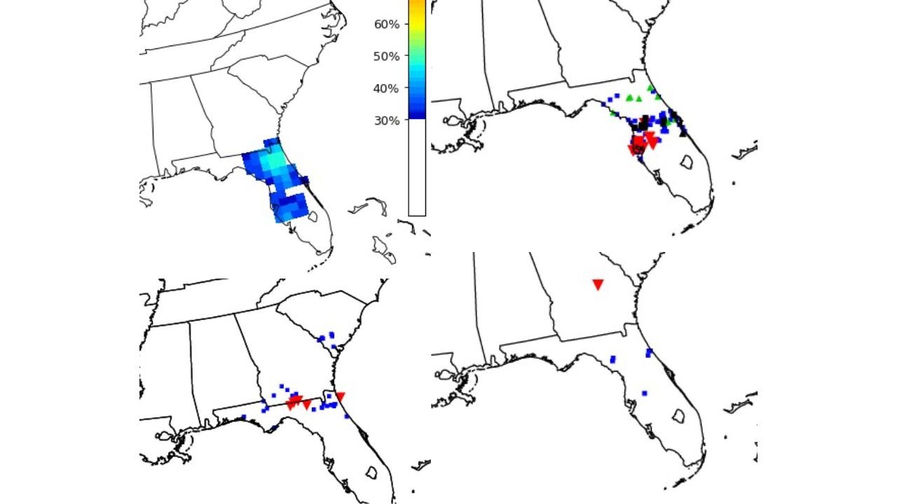
Cities and States in the Risk Zone
North and west Florida carry the highest exposure Saturday. The elevated probability corridor runs across Pensacola, Tallahassee, Gainesville, and Jacksonville, where CIPS analog probabilities reach 60% at the peak. Central Florida including Orlando sits in the 40 to 50% range, while southern Florida drops toward 30% as instability and shear both weaken southward. Adjacent portions of southern Georgia and coastal Alabama also fall within the analog storm footprint based on historical event coverage.
Saturday’s Three Primary Threats
Analog storm reports from the matched historical dates document all three major severe weather hazards. Tornadoes are the headline concern, with confirmed tornado reports appearing in both the April 2020 and April 2018 analogs across north and central Florida. Severe wind gusts represent the most widespread hazard, with blue square markers scattered heavily across the entire Florida-Georgia corridor in all three analog events. Large hail was documented primarily in the April 2018 analog across north Florida, and that potential remains on the table for Saturday as well.
Why North Florida Carries the Greatest Risk
North and west Florida sit closest to the synoptic forcing driving Saturday’s system, which is where the combination of surface-based CAPE and directional wind shear comes together most effectively. CAPE, or Convective Available Potential Energy, measures the fuel available to power thunderstorm updrafts. Wind shear describes how winds change speed and direction with altitude, the ingredient responsible for organizing storms into rotating supercells capable of producing tornadoes. South of roughly the Gainesville to Pensacola corridor, shear values weaken enough that the tornado risk drops considerably, though isolated severe storms remain possible.
Multi-Day Pattern
Saturday’s event fits within the active spring severe weather window that climatologically places Florida at elevated risk throughout April. All three analog dates fall within the same April seasonal window, confirming this setup is consistent with the time of year. Residents should pay close attention to timing updates as morning versus afternoon convective initiation can shift the peak activity window by several hours, which matters significantly for outdoor and travel plans across the state.
What to Watch Next
- Whether tornado watches are issued for the Florida Panhandle and north Florida Saturday morning, which would signal forecaster confidence in rotating storm development
- The exact timing of storm initiation, as morning convection burning off versus afternoon development determines how long the active window lasts
- Wind gust reports across the Gainesville and Tallahassee corridors, where the analog footprint shows the densest severe wind coverage
- Any extension of the threat southward toward Orlando if boundary interactions shift the storm track during the afternoon hours
- Conditions improving Saturday night as the system pushes east and offshore
Residents from Pensacola to Tallahassee to Jacksonville should have a weather alert method active before Saturday morning and know their shelter plan before afternoon storms develop.
WaldronNews.com will continue tracking Saturday’s Florida severe storm setup and provide updates as tornado watch issuances and storm initiation timing become clearer.