
Indiana, Ohio and Illinois Brace for Widespread Rain Return Tuesday and Wednesday as Storm System Targets the Great Lakes and Ohio Valley
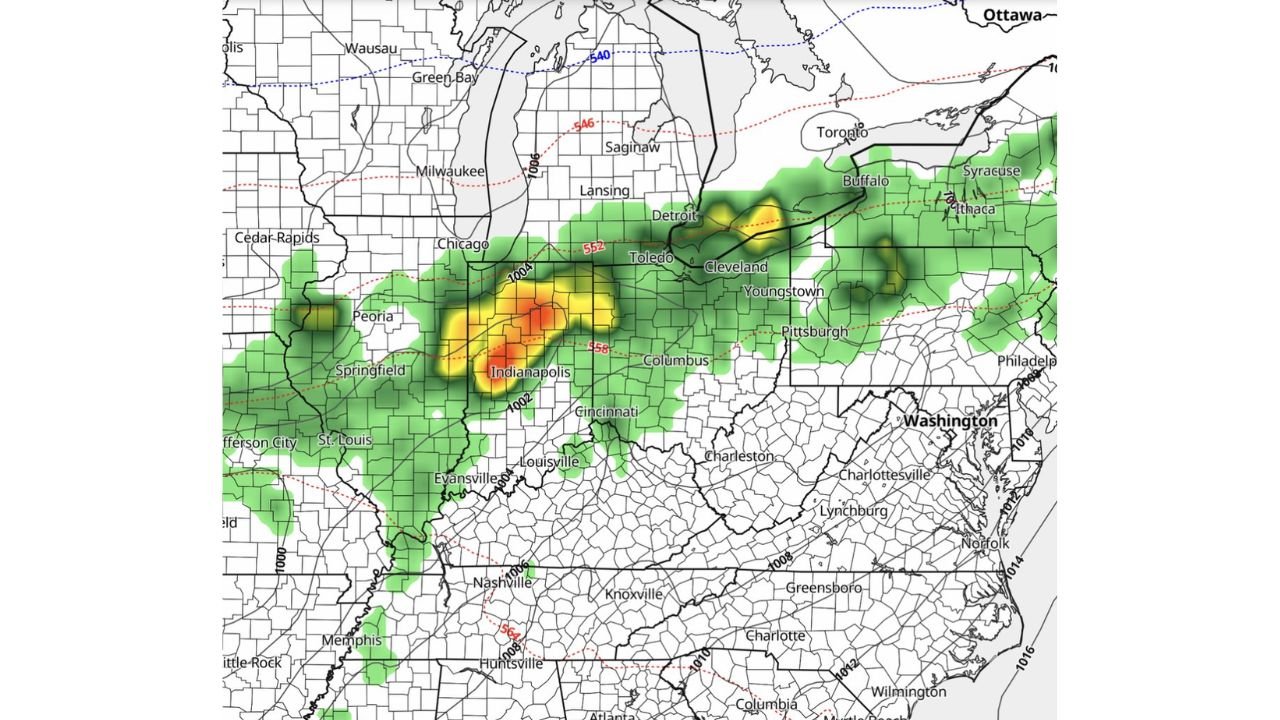
INDIANAPOLIS, Indiana — A widespread rain event is taking shape for next Tuesday and Wednesday, May 5 and 6, with the heaviest activity projected to center over Indiana, Ohio, and Illinois as a storm system pushes through the Great Lakes and Ohio Valley regions. Exact rainfall totals and precise timing remain uncertain at this range, but the simulated radar footprint already tells a clear story — this is a multi-state, multi-day soaking event and the bullseye sits squarely over Indianapolis.
Which Indiana, Ohio and Illinois Cities Are Directly in the Path of Tuesday’s Rain
| City | State | Rain Intensity | Peak Timing |
|---|---|---|---|
| Indianapolis | Indiana | Heaviest — red core | Tuesday afternoon |
| Columbus | Ohio | Heavy | Tuesday afternoon |
| Toledo | Ohio | Moderate to heavy | Tuesday PM |
| Cleveland | Ohio | Moderate | Tuesday evening |
| Peoria | Illinois | Moderate | Tuesday midday |
| Springfield | Illinois | Moderate | Tuesday midday |
| Chicago | Illinois | Light to moderate | Tuesday afternoon |
| Detroit | Michigan | Moderate | Tuesday evening |
| Buffalo | New York | Light to moderate | Tuesday night |
| Pittsburgh | Pennsylvania | Light | Tuesday evening |
| Cincinnati | Ohio | Light — southern edge | Tuesday PM |
| Louisville | Kentucky | Light — southern edge | Tuesday PM |
| Evansville | Indiana | Light — southern edge | Tuesday PM |
The red and yellow radar core sits directly over Indianapolis — meaning the city is not just in the rain zone, it is the center of it. Cities northeast of Indianapolis including Columbus and Toledo follow within hours as the system pushes east.
What Makes This Storm Different From a Typical Spring Rain
Most spring rain events in the Ohio Valley are scattered and hit-or-miss. This one is different for three reasons worth understanding.
First, this is a surface low pressure system with a well-defined center tracking directly through Indiana — not a weak disturbance brushing the region from a distance. The 1002 to 1004 millibar pressure readings over Indiana and Illinois confirm a legitimate storm system, not a passing sprinkle. Second, the precipitation band extends from Illinois all the way to western New York in a single connected shield, which means nearly every major city from Chicago to Buffalo gets wet within the same 24 to 36 hour window. Third, the storm arrives on Tuesday afternoon — peak commute hours for Indianapolis, Columbus, and Cleveland — which means road conditions will deteriorate exactly when the most people are driving.
Heavy Rain and Locally Intense Downpours Expected Tuesday Afternoon
The simulated radar valid Tuesday afternoon shows a well-organized precipitation band pushing from central Illinois eastward through Indiana and into Ohio, with a secondary cluster lifting toward the Great Lakes. The red core over Indianapolis is the critical signal — that depth of radar return means rainfall rates heavy enough to cause standing water on roads, reduced visibility, and potential flash ponding in low-lying areas within the city.
A secondary rain area is visible over Peoria and Springfield, Illinois to the west, indicating the storm’s leading edge will arrive in Illinois before Indianapolis sees its heaviest rain. Michigan, western New York, and western Pennsylvania pick up the lighter green shield extending northeast as the system exits the region Wednesday.
Why Indianapolis Is the Bullseye and What the Pressure Pattern Means
The 1002 millibar low pressure center sitting over Indianapolis on Tuesday afternoon is the engine driving all of this. Low pressure systems pull in moisture from surrounding areas and force that air upward, which is what creates rain. The tighter the pressure gradient — meaning the closer together the pressure lines on the map — the more organized and intense the precipitation becomes.
What the map shows over Indiana is a classic Ohio Valley low track, one of the most reliable rain-producing setups in the region. When lows follow this path, Indianapolis, Columbus, and Cleveland almost always end up in the heaviest rain corridor. Cities south of the track like Louisville and Cincinnati typically catch lighter rain on the southern edge, while cities northeast like Detroit and Buffalo see the system arrive later as it pulls away.
Quick Facts at a Glance
| Detail | What the Data Shows |
|---|---|
| Peak rain day | Tuesday, May 5 |
| Secondary rain day | Wednesday, May 6 |
| Hardest hit city | Indianapolis, Indiana |
| Storm system type | Surface low pressure — 1002 to 1004 mb |
| Rain footprint | Illinois east through western New York |
| Timing concern | Tuesday afternoon — peak commute hours |
| Severe weather risk | Low — monitoring for isolated strong storms |
| Confidence level | Moderate — details sharpen later this week |
Rain Continues Into Wednesday Before the System Clears Northeast
Tuesday carries the heavy rain for Indiana and Ohio. Wednesday extends the wet pattern as the system lifts northeast, shifting the remaining rain coverage toward Michigan, western New York, and western Pennsylvania. Cities like Detroit and Buffalo that see lighter rain Tuesday may pick up additional totals Wednesday as the trailing moisture follows the storm track out. By Wednesday evening, the system should be pushing far enough northeast that Ohio and Indiana begin drying out.
What Great Lakes and Ohio Valley Residents Should Watch Before Tuesday
- Rainfall total forecasts will sharpen significantly through this weekend — watch for updates specifically for Indianapolis, Columbus, and Cleveland where totals matter most
- Storm track shifts of even 50 to 100 miles north or south would meaningfully change which cities see the heaviest rain versus lighter amounts — a northern track benefits Illinois more, a southern track hammers Ohio harder
- Tuesday morning conditions in Illinois will be the first indicator of how organized the storm is — if heavy rain is already falling in Chicago by midmorning, Indianapolis should prepare for the worst of it by early afternoon
- Isolated strong storm potential within the rain shield cannot be ruled out given the low pressure setup — any thunderstorm development Tuesday afternoon over Indiana would be worth watching closely
- Wednesday drying timeline for Indiana and Ohio — if the system slows down, the wet period extends; if it moves fast, clearing arrives sooner
Residents across Indiana, Ohio, and Illinois should expect travel disruptions Tuesday afternoon and plan accordingly. Keep weather alerts active on phones heading into next week.
WaldronNews.com will continue tracking this Tuesday and Wednesday rain event across the Great Lakes and Ohio Valley and provide updates as rainfall totals and timing details become clearer.