
Severe Thunderstorm Watch Issued for Southwest Alabama, Southern Mississippi and Southeast Louisiana Until 9 PM Tonight as 70 MPH Wind Gusts and Ping Pong Size Hail Threaten Over 4 Million Residents
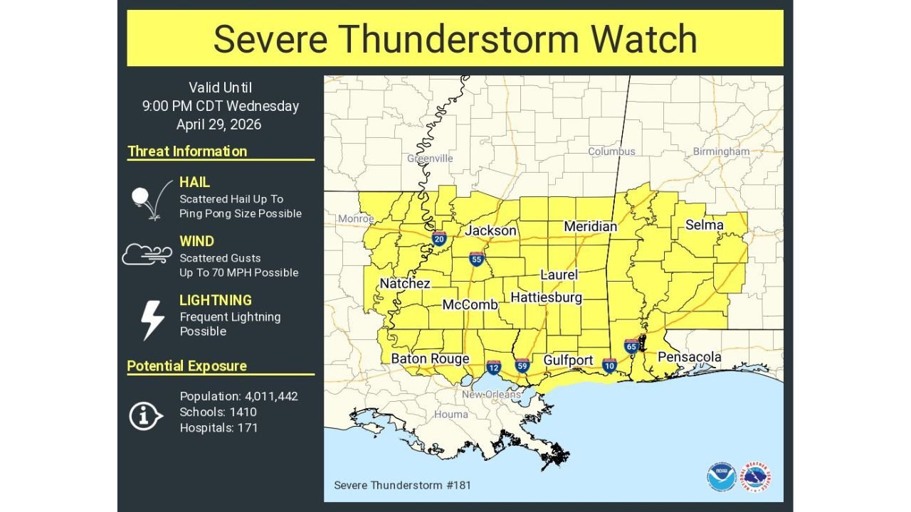
MOBILE, Alabama — A Severe Thunderstorm Watch is in effect until 9:00 PM CDT tonight, Wednesday April 29, 2026 across southwest Alabama, southern Mississippi, and southeast Louisiana, covering a region home to more than 4 million people. Storms firing across this corridor are capable of producing wind gusts up to 70 mph, ping pong ball sized hail, and frequent lightning. This is an active and ongoing severe weather situation — residents from Hattiesburg to Gulfport to Pensacola to Baton Rouge need to be weather-aware for the remainder of the afternoon and evening hours.
Every City Inside the Severe Thunderstorm Watch Zone Right Now
The yellow shading on the watch map covers a large swath from southern Mississippi and southwest Alabama down to the Gulf Coast through southeast Louisiana.
| City | State | Inside Watch Zone |
|---|---|---|
| Hattiesburg | Mississippi | Yes — core zone |
| Laurel | Mississippi | Yes — core zone |
| Meridian | Mississippi | Yes — northern edge |
| Jackson | Mississippi | Yes — northern edge |
| McComb | Mississippi | Yes — core zone |
| Natchez | Mississippi | Yes — western zone |
| Gulfport | Mississippi | Yes — coastal zone |
| Selma | Alabama | Yes — eastern zone |
| Pensacola | Florida | Yes — eastern edge |
| Baton Rouge | Louisiana | Yes — western zone |
| New Orleans | Louisiana | Yes — southern edge |
| Monroe | Louisiana | Yes — western edge |
Over 4 million people, 1,410 schools, and 171 hospitals fall within this watch boundary — numbers that underscore why this is not a routine afternoon storm event.
Three Threats That Make This Watch Dangerous
This is not a single-hazard watch. Three separate and distinct threats are active simultaneously across the watch zone.
| Threat | Severity | What It Means for Residents |
|---|---|---|
| Hail | Ping pong ball size — scattered | Hail this size damages vehicles, shatters windows, injures anyone outdoors |
| Wind gusts | Up to 70 mph — scattered | 70 mph is strong enough to down trees, power lines, and cause structural damage |
| Lightning | Frequent | Dangerous for anyone outdoors across the entire watch zone |
Ping pong ball sized hail measures approximately 1.5 inches in diameter. At that size, hail causes dents in vehicle hoods and roofs, breaks windshields, and destroys outdoor furniture, crops, and garden plants. It falls fast enough to injure anyone caught outside without shelter.
70 mph wind gusts are at the upper end of what severe thunderstorms produce and cross into territory where structural damage to roofs, fences, and outbuildings becomes likely. Trees that are already saturated from recent rainfall are especially vulnerable to snapping or uprooting at these wind speeds.
🌩️ Watch vs Warning — What the Watch Means Right Now
A lot of people confuse these two and it costs them valuable time.
| Term | What It Means | What You Should Do |
|---|---|---|
| Severe Thunderstorm Watch | Conditions are favorable — severe storms are possible in the area | Stay weather-aware, know your shelter, be ready to act fast |
| Severe Thunderstorm Warning | A severe storm has been confirmed — it is happening now | Take shelter immediately — do not wait |
The current watch means the atmosphere is primed and storms are developing. A warning can be issued with very little notice once a severe storm is confirmed on radar. The time to identify your shelter and move vehicles under cover is now — during the watch — not after a warning is issued for your specific county.
Why Southwest Alabama and Southern Mississippi Are the Core of This Event
The watch boundary is not drawn randomly. Southwest Alabama and southern Mississippi sit at the intersection of the Gulf moisture feed and the cold front pushing through the region today. Baton Rouge and New Orleans on the western end are catching storms moving off the Gulf, while Hattiesburg, Laurel, and Gulfport sit in the zone where storms are organizing most effectively as they track northeast. Pensacola on the Florida border catches the eastern edge as the watch zone extends across the state line into the Florida Panhandle.
The 4,011,442 people inside this watch zone live across a mix of urban centers and rural areas — and rural residents need to pay particular attention because response times for emergency services after wind damage or hail injury are significantly longer outside city limits.
What Residents Must Do Before 9 PM Tonight
- Move vehicles into garages or covered parking immediately — ping pong ball hail will dent and crack every unprotected vehicle in its path and the damage happens in seconds
- Anyone outdoors in Hattiesburg, Gulfport, Laurel, or Pensacola should be inside a sturdy building before afternoon storms develop — do not rely on being able to outrun developing storms once they fire
- Baton Rouge and New Orleans residents should be aware that storms approaching from the northwest can move quickly once they organize — the watch extends to your area and warnings can be issued with minimal lead time
- Schools inside the watch zone — all 1,410 of them — should have severe weather protocols active for afternoon dismissal, as storm timing aligns directly with the 3 to 5 PM window
- Monitor for Severe Thunderstorm Warnings county by county — when a warning is issued for your county the storm is already confirmed severe and you have minutes, not hours, to reach shelter
- Stay off the roads once warnings begin firing across the watch zone — 70 mph wind gusts on highways with rain-reduced visibility create extremely dangerous driving conditions
The watch expires at 9:00 PM CDT tonight but individual warnings within the watch zone will continue to be issued on a storm-by-storm basis as long as severe thunderstorms remain active across southern Mississippi and southwest Alabama.
WaldronNews.com will continue tracking Severe Thunderstorm Watch 181 across Alabama, Mississippi, Louisiana, and Florida and provide updates as warnings are issued and storm reports come in through tonight.