
Frontal Line Storms Target Upper Gulf Coast, North Florida and Lower Georgia Friday Into Saturday With Heavy Rain Possible
TALLAHASSEE, Florida — A lingering frontal boundary is setting up a two-day storm event across the upper Gulf Coast, north Florida, and lower Georgia from Friday May 1 through Saturday May 2, with storm outlooks issued for both days placing the region inside active thunderstorm and marginal severe weather zones. The front is not moving quickly, which means repeated rounds of storms are possible across the same areas over a 48-hour window. Rainfall totals are still bouncing around in the forecast models, but heavy rain is possible for some communities, and the entire state of Florida is expected to see rain dip through at some point this weekend.
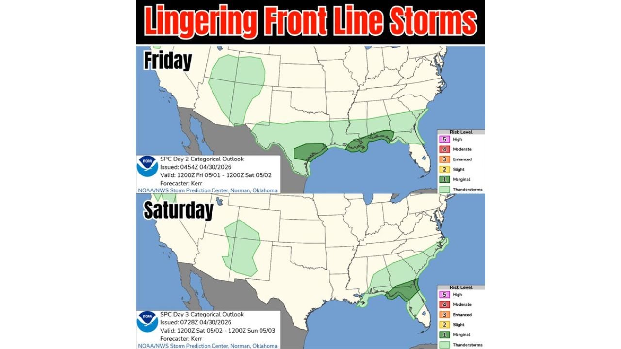
Friday and Saturday Outlooks Side by Side
| Detail | Friday May 1 | Saturday May 2 |
|---|---|---|
| Valid period | 1200Z Friday through 1200Z Saturday | 1200Z Saturday through 1200Z Sunday |
| Risk level shown | Marginal — Level 1 with thunderstorm area | Marginal — Level 1 with thunderstorm area |
| Primary threat zone | Upper Gulf Coast into north Florida and lower Georgia | Florida shifting south, continued Gulf Coast activity |
| Heavy rain potential | Yes, for some areas | Yes, continuing south through Florida |
| Severe weather risk | Low but not zero | Low but not zero |
| Front movement | Slow and lingering | Continues pushing south through Florida |
Where the Storms Set Up Across Both Days
The Friday outlook shows the storm activity concentrated along the upper Gulf Coast from Louisiana eastward through Mississippi, Alabama, and into the north Florida Panhandle with the risk zone extending into lower Georgia and South Carolina. The deeper green thunderstorm designation covers a broad area suggesting organized storm activity is expected, not just isolated showers.
By Saturday the frontal boundary has pushed further south and the active zone shifts with it, pushing rain and storm potential down through the Florida Peninsula. The Saturday outlook maintains the marginal risk designation across Florida while the Gulf Coast activity continues. This two-step progression is what allows rain to reach all the way through Florida by the end of the weekend.
Cities Across the Threat Corridor Friday and Saturday
| City | State | Friday Threat | Saturday Threat |
|---|---|---|---|
| Pensacola | Florida | Active — inside primary zone | Continued activity |
| Tallahassee | Florida | Active — inside primary zone | Frontal passage |
| Jacksonville | Florida | Active — eastern edge | Continued rain |
| Gainesville | Florida | Marginal zone | Rain pushes through |
| Orlando | Florida | Outside Friday zone | Rain reaches here Saturday |
| Tampa | Florida | Outside Friday zone | Rain pushes south Saturday |
| Mobile | Alabama | Active — upper Gulf zone | Lingering activity |
| Savannah | Georgia | Lower Georgia fringe | Clearing begins |
| New Orleans | Louisiana | Western edge of activity | Mostly clear |
Why a Slow Front Means More Rain for the Same Areas
A fast-moving cold front pushes through a region in a matter of hours and moves on. A lingering frontal boundary behaves completely differently and is often responsible for the most significant rainfall totals in any given event.
| Front Type | How It Behaves | Rainfall Result |
|---|---|---|
| Fast-moving front | Passes through in 3 to 6 hours | Brief but potentially intense rain, then clearing |
| Lingering front | Stalls or moves very slowly | Repeated storm development along the same boundary for 24 to 48 hours |
| This weekend’s front | Slow southward progression through Florida | Multiple rounds of storms, heaviest totals where the front stalls longest |
When a front lingers over the same geography, new storm cells keep forming along the boundary and tracking over the same communities repeatedly. This is how rainfall totals that seem manageable in a single storm event can accumulate to significant totals over a 48-hour period.
What Florida, Georgia and Gulf Coast Residents Should Know Before Friday
- North Florida and Panhandle residents face the most active storm window on Friday. The front arrives first in this corridor and the marginal severe risk combined with a thunderstorm designation means organized storms are expected, not just light rain.
- Rainfall totals are still uncertain according to the forecast discussion. Models are producing a range of possible totals and the final numbers will depend heavily on exactly how slow the front moves and where the heaviest training storm bands set up.
- Central and South Florida should not assume this event stays in north Florida. The Saturday progression pushes rain southward through the entire peninsula, and Orlando, Tampa, and Miami should all expect rain at some point Saturday.
- Lower Georgia residents from Valdosta through Savannah sit on the eastern fringe of Friday’s activity. The front approaches from the west and rain coverage in Georgia will increase through Friday before the boundary pushes past.
- Heavy rain is possible for some but not guaranteed for everyone inside the threat zone. The lingering frontal setup means one community could receive 2 to 3 inches while a nearby area gets a quarter inch, depending on exactly where the training storm bands develop.
WaldronNews.com will continue tracking Friday and Saturday storm activity across the Gulf Coast, north Florida, and Georgia and provide updates on rainfall totals and severe weather potential as the frontal boundary approaches.