
North Florida and South Florida Face Heavy Rain and Elevated Severe Weather Risk May 1 Through 4 While Central Florida Sees Lower Totals
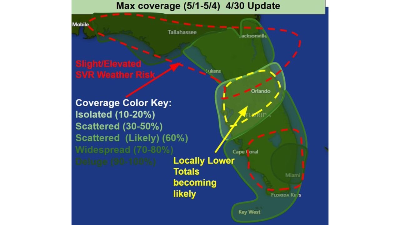
ORLANDO, Florida — The Florida rainfall picture for May 1 through May 4 is coming into sharper focus with the April 30 update, and it reveals a tale of two Floridas. North Florida is locked in for a good soaking with an elevated and slight severe weather risk attached, and South Florida is seeing increasing severe weather chances as well. But Central Florida including the Orlando metro is increasingly likely to see locally lower rainfall totals than surrounding regions, sitting in a coverage gap between the two more active zones to the north and south.
What Each Region of Florida Gets May 1 Through 4
| Region | Rain Coverage | Severe Weather Risk | Key Detail |
|---|---|---|---|
| North Florida Panhandle | Widespread 70 to 80% | Slight to elevated SVR risk | Good soaking expected, front most active here |
| North Florida — Jacksonville corridor | Scattered likely 60% | Slight to elevated SVR risk | Inside the red dashed elevated risk zone |
| Central Florida — Orlando metro | Scattered 30 to 50% | Lower | Locally lower totals becoming likely |
| South Florida — Miami corridor | Scattered to widespread | SVR chances increasing | Separate severe weather risk developing |
| Florida Keys | Scattered 30 to 50% | Lower | Southern fringe of activity |
| Cape Coral and Southwest Florida | Scattered likely 60% | Moderate | Between the central gap and south zone |
The Coverage Map Decoded — What Each Color Means
The coverage map uses color shading to show how much of each area will see rain during the May 1 through 4 window. Here is exactly what each category means for residents on the ground.
| Coverage Category | Percentage | What It Means |
|---|---|---|
| Isolated | 10 to 20% | Most spots stay dry, only a few locations see rain |
| Scattered | 30 to 50% | About half the area sees rain at some point, hit or miss |
| Scattered Likely | 60% | More likely than not to see rain, still some dry spots |
| Widespread | 70 to 80% | Most of the area gets wet, only a few lucky dry spots |
| Dense | 90 to 100% | Essentially everyone in the area sees rain |
North Florida sits in the widespread 70 to 80% zone. That means if you live anywhere in the Panhandle or north Florida corridor, rain is coming at some point during the four-day window and meaningful totals are expected. Central Florida near Orlando sits in the scattered 30 to 50% range, meaning roughly half the metro could stay dry while nearby areas pick up rain.
Why North Florida and South Florida Both Carry Elevated Severe Weather Risk
The red dashed line on the map outlines the slight to elevated severe weather risk zone and it covers a large horseshoe shape wrapping around the Florida Panhandle, north Florida, and curving down through South Florida and the Keys. Central Florida sits notably inside the yellow dashed zone labeled locally lower totals, which places it in a different category from both ends of the state.
| Why North Florida Has SVR Risk | Why South Florida SVR Is Increasing |
|---|---|
| Cold front pushing through the Panhandle creates forcing for organized severe storms | Separate moisture interaction developing along the South Florida coast |
| Wind shear strongest in the north where the front is most active | Instability building ahead of the frontal boundary as it pushes south |
| Tornadic supercell potential exists where shear and instability overlap | Storm organization possible as Gulf moisture feeds into the southern peninsula |
What Central Florida Residents Need to Understand About Lower Totals
The locally lower totals becoming likely label over the Orlando metro does not mean zero rain and it does not mean no severe weather risk. It means the coverage is expected to be less than surrounding regions, creating a relative dry slot compared to north and south Florida.
For Orlando residents watching this pattern, the practical implication is that the most dramatic rain and storm activity will be happening in areas to the north and south simultaneously while the metro sits in between. Individual storms can still reach Central Florida during the four-day window, but the systematic widespread coverage seen in north Florida is not expected to materialize across the I-4 corridor in the same way.
What to Watch Through May 4 Across Florida
- North Florida severe weather timing as the cold front pushes through the Panhandle. The slight to elevated SVR risk means tornado watches and warnings are possible during the most active frontal passage period.
- Whether South Florida’s increasing SVR chances translate into organized severe storm development. The pattern is still evolving and confidence in the southern severe risk is lower than the northern risk at this update.
- Orlando and Central Florida rainfall totals could still surprise to the upside if storm coverage shifts slightly west or east from current expectations. The locally lower total signal is a trend, not a guarantee.
- Multi-day rainfall accumulation across North Florida where widespread coverage over four days could produce significant totals even without any single event delivering extreme amounts.
- The next update will sharpen confidence in the coverage boundaries as the May 1 start date arrives and actual storm initiation begins confirming or modifying the current forecast.
WaldronNews.com will continue tracking the May 1 through 4 Florida weather pattern and provide updates on severe weather watches, rainfall totals, and coverage shifts as the event unfolds.