
Louisiana, Mississippi, Alabama, Tennessee, and Kentucky Face 3 or More Inches of Rain Next Week as Deep South and Lower Ohio Valley Brace for Multiple Rainy Days Through May 8
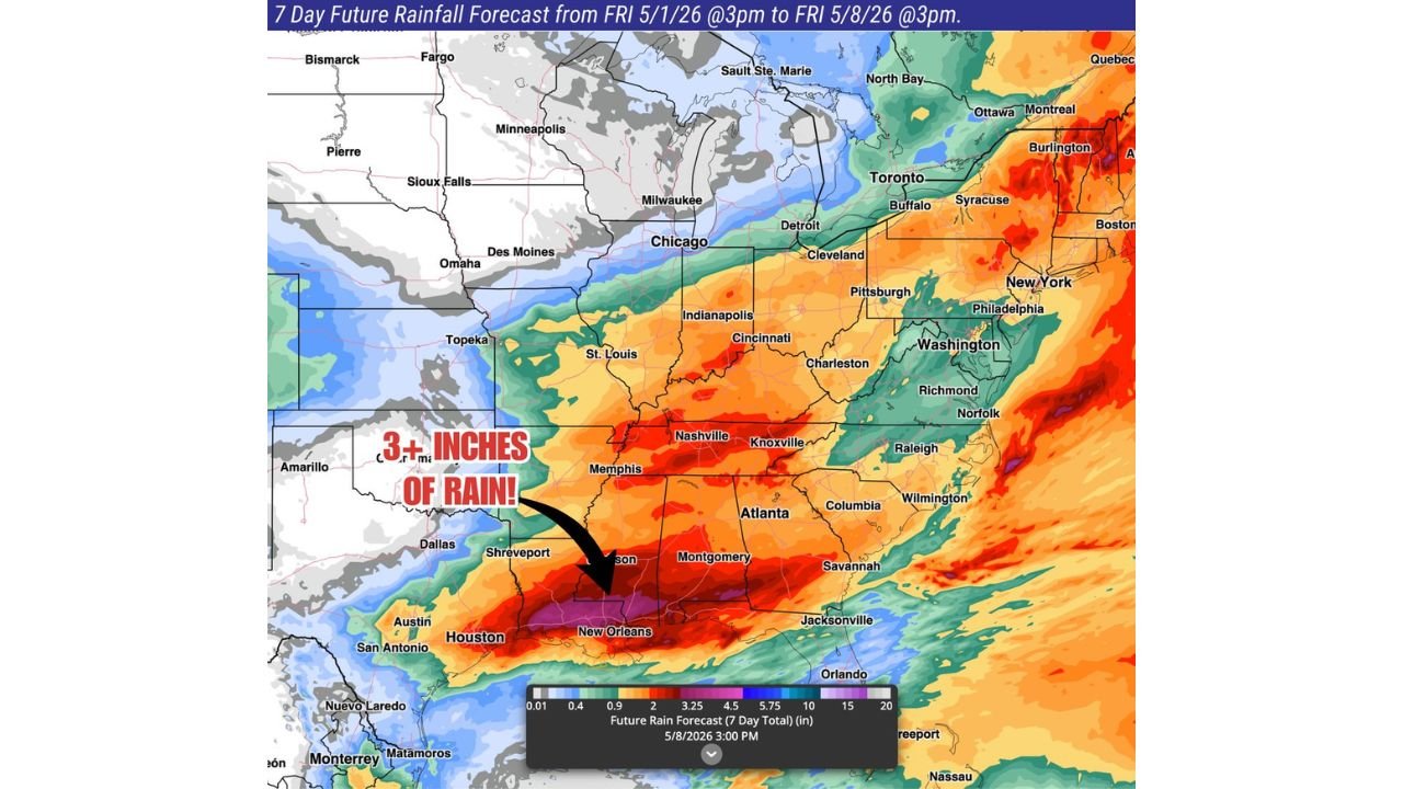
NEW ORLEANS, Louisiana — The Deep South and lower Ohio Valley are heading into a prolonged wet stretch next week, with the 7-day rainfall forecast valid from Friday May 1 through Friday May 8 showing 3 or more inches of rain piling up across Louisiana, Mississippi, and Alabama as multiple storm systems push through the region on consecutive days. The deepest totals on the map sit over the New Orleans and southern Louisiana corridor where purple shading indicates the potential for the highest accumulations of the entire event. Planting and field work across the Deep South will face serious disruption as rain chances persist for multiple days without a meaningful dry window in between.
7-Day Rainfall Forecast by City and Region
| City | State | 7-Day Rainfall Forecast |
|---|---|---|
| New Orleans | Louisiana | Highest totals — purple zone, potentially 5 to 10 inches |
| Jackson | Mississippi | 3 or more inches — deep red and orange zone |
| Shreveport | Louisiana | 3 or more inches — red zone |
| Montgomery | Alabama | 3 or more inches — orange to red zone |
| Memphis | Tennessee | 2 to 3 inches — orange zone |
| Nashville | Tennessee | 1.5 to 2.5 inches — yellow to orange zone |
| Atlanta | Georgia | 1 to 2 inches — yellow zone |
| Indianapolis | Indiana | 1 to 2 inches — yellow zone |
| Cincinnati | Ohio | 1 to 2 inches — yellow zone |
| St. Louis | Missouri | 1 to 2 inches — yellow to orange fringe |
| Chicago | Illinois | Under 1 inch — light green zone |
| Dallas | Texas | 1 to 2 inches — yellow zone |
| Houston | Texas | 2 to 3 inches — orange zone |
| Raleigh | North Carolina | 2 to 4 inches — orange to red zone |
| Washington D.C. | District of Columbia | 2 to 3 inches — orange zone |
| Philadelphia | Pennsylvania | 2 to 3 inches — orange zone |
| New York City | New York | 2 to 3 inches — orange zone |
The purple bullseye over southern Louisiana near New Orleans represents the highest rainfall concentration on the entire map, where multiple storm systems stacking over the same geography could push totals well above the 3-inch threshold shown across the broader Deep South.
Why the Deep South Gets Hit Hardest This Week
| Factor | How It Drives Heavy Rain Totals |
|---|---|
| Multiple storm systems | Rain chances expected to last multiple days, not a single event |
| Gulf of Mexico moisture | Continuous moisture feed from the Gulf keeps storms fueled as each system moves through |
| Slow pattern progression | Systems moving slowly means the same areas get rained on repeatedly rather than a single quick hit |
| Lower Ohio Valley convergence | The Ohio Valley acts as a funnel where Gulf moisture and frontal boundaries interact repeatedly |
The combination of Gulf moisture availability and a slow-moving pattern is the key reason Louisiana and Mississippi accumulate the deepest totals. When storms can continuously tap Gulf moisture while tracking slowly through the same corridor, individual events that might produce 0.5 to 1 inch each day stack up into 3 to 5 inch weekly totals without any single dramatic rainfall event.
🌧️ What 3 or More Inches Over Multiple Days Means for Agriculture
The forecast directly calls out that planting and field work will be difficult across the Deep South and lower Ohio Valley next week. This is not a casual observation.
| Agricultural Impact | Detail |
|---|---|
| Field saturation | 3 inches over multiple days saturates soil past the point where equipment can work without causing compaction or getting stuck |
| Planting window lost | Every wet day during planting season represents lost planting capacity that cannot easily be recovered |
| Crop disease risk | Extended wet periods increase fungal disease pressure on established crops, particularly in the humid Deep South |
| Livestock management | Soggy pastures and flooded low-lying fields force livestock movement and increase health risks |
| Harvest disruption | Any winter crop still in the field faces quality loss under persistent wet conditions |
For farmers across Mississippi, Alabama, Louisiana, and Tennessee, next week represents a significant operational challenge at a time of year when dry windows are critical for establishing summer crops.
The Lower Ohio Valley and Eastern Seaboard Picture
The heavy rain footprint is not limited to the Deep South. The rainfall map shows a broad orange and red swath extending up the Eastern Seaboard from the Carolinas through the Mid-Atlantic and into New England.
| Region | 7-Day Total | Key Cities |
|---|---|---|
| Carolinas | 2 to 4 inches | Raleigh, Charlotte, Wilmington |
| Mid-Atlantic | 2 to 3 inches | Washington D.C., Philadelphia, Richmond |
| Northeast | 2 to 3 inches | New York City, Boston area |
| Lower Ohio Valley | 1.5 to 2.5 inches | Indianapolis, Cincinnati, Louisville |
| Upper Midwest | Under 1 inch | Chicago, Milwaukee, Minneapolis |
The eastern corridor rainfall is a separate story from the Deep South totals. While Louisiana and Mississippi deal with Gulf moisture-driven heavy rain, the East Coast accumulations come from frontal systems tracking northeast along the coast, delivering a prolonged wet week from North Carolina through New England.
What Residents Across the Deep South and Ohio Valley Should Do Before Next Week
- Louisiana and Mississippi residents should prepare for the wettest seven-day stretch of the spring season. The purple and deep red zones on the map indicate totals that will flood low-lying areas, overwhelm drainage systems, and make roads in rural areas impassable by midweek.
- Farmers across Alabama, Tennessee, and Mississippi should complete any critical planting or field operations this weekend while conditions are still dry. Once the wet pattern locks in Monday, multiple consecutive days without a workable window are expected through May 8.
- Nashville and Memphis residents in the 2 to 3 inch zone face a week of persistent rain rather than a single storm event. Flash flooding in urban areas becomes more likely when rainfall accumulates over multiple days rather than arriving all at once.
- New Orleans area residents sit under the deepest rainfall signal on the entire 7-day map. Totals in the purple zone could push well above 5 inches depending on how efficiently the Gulf moisture feed sustains storm development over southern Louisiana throughout the week.
- Lower Ohio Valley communities from Indianapolis through Cincinnati and Louisville should monitor river and stream levels through the week as daily rainfall additions push waterways progressively higher without dry days allowing levels to recede.
- Watch for flash flood watches and warnings to be issued across Louisiana and Mississippi by early next week as the rainfall pace becomes clearer. The 3-inch weekly total is a forecast average — individual storm events within the week can dump 1 to 2 inches in a matter of hours.
WaldronNews.com will continue tracking next week’s Deep South and Ohio Valley rainfall pattern and provide updates on flood watches, storm timing, and total accumulation forecasts through May 8.