
Ohio, Indiana, Kentucky, and Tennessee Face 170 to 245 Percent of Normal Rainfall May 2 Through 9 While North Dakota and Nebraska Sit at 5 to 10 Percent
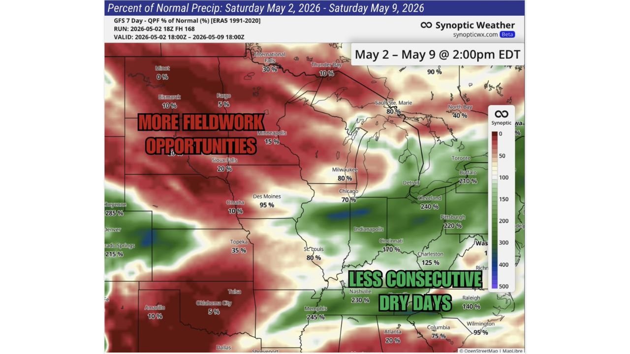
INDIANAPOLIS, Indiana — The seven-day rainfall outlook from Saturday May 2 through Saturday May 9 is drawing a dramatic line across the country that separates farmers who cannot get into their fields from farmers who can work freely but are watching their soils dry out further. The Eastern Agricultural Belt covering Ohio, Indiana, Kentucky, Tennessee, and the Mid-Atlantic is forecast to receive 170 to 245 percent of normal rainfall over the seven-day period, creating saturated soils and limited field work windows. Meanwhile the Western Agricultural Belt from North Dakota through Nebraska and Kansas is receiving as little as 5 to 10 percent of normal rainfall, keeping fields workable but deepening an already concerning soil moisture deficit heading into the critical growing season.
Seven-Day Rainfall Percent of Normal by City
| City | State | Percent of Normal Rainfall May 2 to 9 |
|---|---|---|
| Minot | North Dakota | 0% |
| Bismarck | North Dakota | 10% |
| Fargo | North Dakota | 5% |
| Minneapolis | Minnesota | 15% |
| Sioux Falls | South Dakota | 20% |
| Omaha | Nebraska | 10% |
| Des Moines | Iowa | 95% |
| Topeka | Kansas | 35% |
| Oklahoma City | Oklahoma | 5% |
| Tulsa | Oklahoma | 80% |
| Amarillo | Texas | 10% |
| Cheyenne | Wyoming | 285% |
| Colorado Springs | Colorado | 215% |
| International Falls | Minnesota | 30% |
| Thunder Bay | Ontario | 10% |
| Sault Ste. Marie | Michigan | 80% |
| Milwaukee | Wisconsin | 80% |
| Chicago | Illinois | 70% |
| Detroit | Michigan | 210% |
| Cleveland | Ohio | 240% |
| Pittsburgh | Pennsylvania | 220% |
| Buffalo | New York | 210% |
| Indianapolis | Indiana | 170% (estimated from map) |
| Cincinnati | Ohio | 170% |
| Charleston | West Virginia | 125% |
| Nashville | Tennessee | 230% |
| Memphis | Tennessee | 245% |
| Atlanta | Georgia | 20% |
| Columbia | South Carolina | 75% |
| Wilmington | North Carolina | 95% |
| Raleigh | North Carolina | 140% |
| Washington D.C. area | District of Columbia | 100% or above |
| St. Louis | Missouri | 80% |
The Eastern vs Western Farm Belt Split
This is the core story of the next seven days for American agriculture and it could not be more stark.
| Region | 7-Day Rainfall Percent | Field Work Outlook | Soil Moisture Trend |
|---|---|---|---|
| North Dakota, South Dakota | 0 to 20% | Excellent fieldwork windows | Drying further — drought concern deepening |
| Nebraska, Kansas | 5 to 35% | Good fieldwork windows | Drying further — planting conditions workable but dry |
| Iowa | 95% | Near normal — some rain delays | Holding steady |
| Missouri, Illinois | 70 to 80% | Some rain delays but manageable | Adequate |
| Ohio, Indiana, Kentucky | 170 to 240% | Multiple rain delays, wet soils | Saturating — planting difficult |
| Tennessee, West Virginia | 125 to 245% | Significant field work limitations | Saturating — field equipment at risk of getting stuck |
| Pennsylvania, New York | 210 to 220% | Heavy rain delays | Saturating |
| Mid-Atlantic | 95 to 140% | Some delays | Improving from drought conditions |
🌧️ What Percent of Normal Rainfall Actually Means for Farmers
The percent of normal numbers on this map are not abstract statistics. They translate directly into planting schedules, equipment decisions, and crop outcomes.
| Percentage | What It Means on the Ground |
|---|---|
| 0 to 20% of normal | Essentially no rain. Soils drying rapidly. Dust conditions possible. Irrigation demand rising. |
| 20 to 50% of normal | Well below normal. Fieldwork easy but soil moisture depleting. Dry stress beginning for established crops. |
| 80 to 100% of normal | Near normal. Balanced conditions, some rain delays but overall manageable week. |
| 125 to 170% of normal | Above normal. Soil moisture building, increasing number of days too wet to operate equipment. |
| 200% or more of normal | More than double normal rain. Fields saturating rapidly, equipment compaction risk high, planting windows closing, flood risk in low areas. |
Cleveland at 240% of normal and Memphis at 245% of normal represent the most extreme eastern totals on the map. Both cities are forecast to receive more than double their normal May 2 through 9 rainfall, meaning farmers across northern Ohio and western Tennessee are facing one of the most difficult seven-day field work stretches of the spring season.
What Minot and Bismarck at 0 to 10 Percent Means for the Northern Plains
The North Dakota numbers deserve separate attention because 0% of normal rainfall is not just a dry week. In context of the broader pattern, it represents a continuing dry stretch that is building toward genuine agricultural drought conditions across the Northern Plains.
| City | Percent of Normal | Cumulative Concern |
|---|---|---|
| Minot | 0% | No measurable rain forecast for the entire 7-day period |
| Bismarck | 10% | Essentially dry, minor sprinkle at best |
| Fargo | 5% | Dry conditions continue |
| Minneapolis | 15% | Well below normal, limited rain chances |
Topsoil in these areas is drying from the surface down during a period when spring moisture is critical for establishing corn and soybean root systems. Farmers in this corridor have excellent field work windows but they are planting into soil that is getting drier by the day with no meaningful rain relief on the seven-day horizon.
What Each Region’s Farmers Need to Know This Week
Ohio, Indiana, and Kentucky farmers facing 170 to 240% of normal rainfall should plan their week around the drier windows between storm systems rather than hoping for extended dry periods. Equipment moving through saturated soils causes compaction that reduces yields for the entire season. Waiting an extra day for soils to firm up after rain pays dividends through harvest.
Tennessee and Pennsylvania farmers in the 220 to 245% of normal zone face the most challenging field work week in the Eastern Belt. Multiple consecutive rain events without adequate drying time between them means fields that were borderline workable Monday may be completely impassable by Wednesday after additional rain accumulates.
North Dakota, Nebraska, and Kansas farmers have the opposite problem. The dry window is a genuine opportunity to complete planting operations, but each additional dry day depletes soil moisture that seeds need for germination and early root development. Getting crops in the ground efficiently this week matters more than it would in a normal moisture year.
Iowa and Missouri farmers near the dividing line between the wet east and dry west sit in the most balanced position with 80 to 95% of normal rainfall, facing some rain delays but generally workable conditions for the week.
What to Watch Through May 9
- Whether the 240% of normal zone over Cleveland and Pittsburgh expands further south and west into Indiana as additional storm systems track through the Ohio Valley next week
- Flooding concerns in low-lying agricultural areas of Tennessee and Kentucky where 230 to 245% of normal rainfall over seven days creates river and stream rises that threaten cropland
- Whether North Dakota and Nebraska receive any pattern shift that brings even partial rainfall relief before the dry soil moisture deficit becomes critical for newly planted crops
- Planting progress reports from Ohio, Indiana, and Kentucky as farmers assess how many additional days of delay the wet pattern creates for corn and soybean planting schedules
- The transition pattern after May 9 that will determine whether the wet east and dry west split continues into the third week of May or whether a more balanced rainfall distribution returns to both regions
WaldronNews.com will continue tracking the Eastern and Western Agricultural Belt rainfall split through May 9 and provide updates on planting conditions, flood risk, and soil moisture trends across both regions.