
United States Faces Multi-Threat Hazards Week From May 5 to May 9 as Severe Weather, Frost and Heavy Rain Target Millions Across Multiple Regions
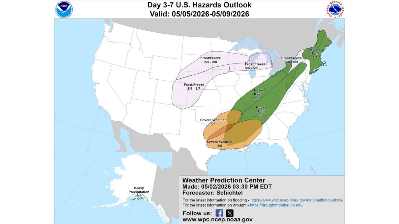
WASHINGTON, D.C. — A sweeping multi-hazard outlook covering the United States from May 5 through May 9 shows three separate and simultaneous threats developing across the country this week. Severe weather targets the South, frost and freeze conditions spread across the Northern Plains and Great Lakes, and heavy rain pushes through the East Coast and Northeast, creating a dangerous and complex week for residents across dozens of states.
Severe Weather: May 5 and May 6
The south-central United States faces back-to-back severe weather days to open the week.
May 5 brings the first round, with an initial severe weather zone developing across portions of the central South. May 6 is the more significant day, with a larger and deeper orange-shaded zone expanding through the Deep South, indicating higher forecaster confidence in a more impactful event.
States most directly targeted:
- Mississippi
- Louisiana
- Arkansas
- Tennessee
Frost and Freeze: May 5 Through May 9
The frost and freeze threat is the most geographically widespread hazard of the week, affecting multiple regions across several consecutive days.
- May 5 to May 8 — Northern Plains and upper Midwest, the longest-duration cold zone on the map
- May 6 to May 8 — Great Lakes region
- May 6 to May 7 — Central Plains
- May 8 to May 9 — Northeast and mid-Atlantic states
Farmers, gardeners and anyone with early spring plantings across these regions face potential crop and vegetation damage through the end of the week.
Heavy Rain: May 5 Through May 7
A heavy rain corridor pushes northward along the Eastern Seaboard over three days.
- May 5 — Central Appalachians and mid-Atlantic region
- May 5 — A second separate zone along the southern East Coast signals broad and widespread rainfall
- May 7 — Rain reaches the Northeast and New England as the system continues pushing north
Repeated rounds of heavy rain over consecutive days raise flooding concerns across low-lying and flood-prone areas from Virginia through Maine.
What to Watch This Week
- Mississippi, Louisiana, Arkansas and Tennessee residents should monitor daily updates as May 6 approaches, the more dangerous of the two severe weather days
- Northern Plains and Great Lakes residents with agriculture or outdoor plants should prepare for multiple freeze nights through May 8
- East Coast communities from the mid-Atlantic through New England should watch for flooding as heavy rain moves through May 5 to May 7
- Details for each individual threat will sharpen significantly as each date gets closer
WaldronNews.com will continue tracking all hazards shown in this outlook and will provide updated coverage for each threat as the week of May 5 through May 9 approaches.