
Virginia and Maryland Face Freeze Warnings and Frost Advisories Tonight West of Washington D.C. as Temperatures Drop to Mid-30s Before 80-Degree Warmth Returns by Tuesday
WINCHESTER, Virginia — Freeze warnings and frost advisories are in effect tonight across western Virginia and western Maryland, stretching from Oakland and Cumberland in Maryland down through Winchester, Harrisonburg, Staunton, and Charlottesville in Virginia. Skies are clearing late tonight and temperatures are dropping fast, bottoming out in the mid-30s to mid-40s with the coldest readings in the western mountain communities. Tender plants left outdoors tonight face real damage risk. The cold is short-lived. Sunday turns milder and temperatures climb into the 80s by Tuesday before the next rain chance arrives.
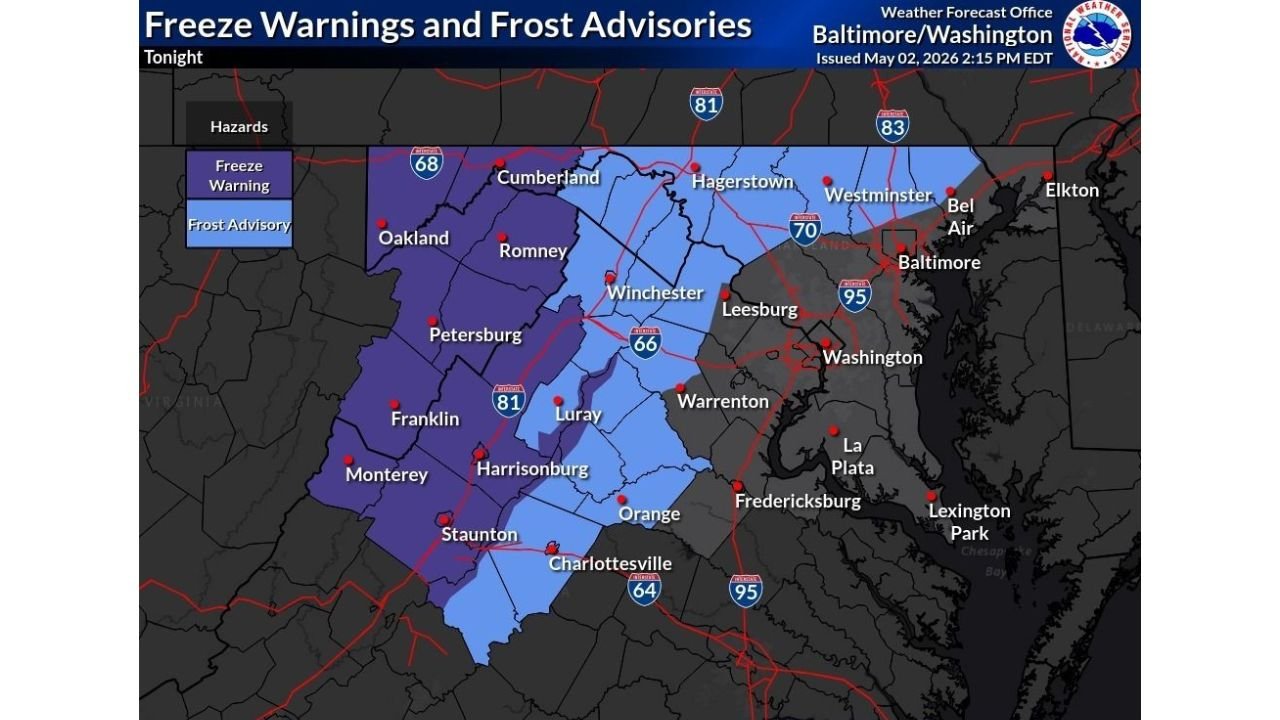
Who Is Under a Freeze Warning vs Frost Advisory Tonight
The map draws a clear line between two different levels of cold threat across the region.
| Alert Level | What It Means | Communities Included |
|---|---|---|
| Freeze Warning — darker blue | Temperatures expected to drop to 32 degrees or below. Plant tissue freezes and dies. More serious than a frost advisory. | Oakland, Petersburg, Franklin, Monterey, Harrisonburg, Staunton, Luray, parts of Charlottesville area |
| Frost Advisory — lighter blue | Temperatures between 33 and 36 degrees. Frost forms on surfaces. Tender plants damaged. | Cumberland, Hagerstown, Westminster, Winchester, Leesburg, Warrenton, Orange, remaining Charlottesville area |
The Freeze Warning zone covers the highest elevation and most rural western communities where cold air pools most effectively on clear nights. The Frost Advisory zone covers the lower elevation and more suburban communities closer to the I-81 and I-66 corridors where urban influence and slightly lower elevation moderate the overnight lows just enough to stay above the freezing mark.
Overnight Low Temperature Range by Location
| City | Alert | Expected Low |
|---|---|---|
| Oakland | Freeze Warning | Mid-30s or below |
| Petersburg | Freeze Warning | Mid-30s or below |
| Monterey | Freeze Warning | Mid-30s or below |
| Franklin | Freeze Warning | Mid-30s or below |
| Harrisonburg | Freeze Warning | Mid-to-upper 30s |
| Staunton | Freeze Warning | Mid-to-upper 30s |
| Luray | Freeze Warning | Mid-to-upper 30s |
| Charlottesville | Frost Advisory to Freeze Warning border | Upper 30s |
| Cumberland | Frost Advisory | Upper 30s |
| Hagerstown | Frost Advisory | Upper 30s to low 40s |
| Winchester | Frost Advisory | Upper 30s to low 40s |
| Leesburg | Frost Advisory | Low 40s |
| Warrenton | Frost Advisory | Low 40s |
| Orange | Frost Advisory | Low 40s |
| Westminster | Frost Advisory | Low to mid 40s |
| Baltimore | Outside alert zone | Mid-40s |
| Washington D.C. | Outside alert zone | Mid-40s or above |
| Fredericksburg | Outside alert zone | Mid-40s |
🌡️ Why Temperatures Drop So Fast Tonight
The two key ingredients driving tonight’s sharp temperature drop are sky clearing and low humidity left behind after recent rain.
| Factor | How It Drives Tonight’s Cold |
|---|---|
| Late clearing skies | Cloud cover acts like a blanket trapping heat near the surface. Once clouds clear late tonight, that blanket is gone and temperatures fall rapidly. |
| Dry air behind the front | Low humidity allows heat to escape the surface much more quickly than on humid nights, accelerating the overnight temperature drop. |
| Clear skies and radiational cooling | With nothing to stop heat loss from the ground, surface temperatures can drop 15 to 20 degrees in just a few hours after sunset on a dry clear night. |
| Western terrain and elevation | Higher elevation western communities like Oakland and Monterey sit at altitudes where temperatures are naturally several degrees colder than valley communities, pushing them into hard freeze territory. |
What the Week Ahead Looks Like After Tonight’s Cold
Tonight is a sharp but brief cold event. The recovery after Sunday morning is one of the quickest in recent memory.
| Day | Conditions | Temperature |
|---|---|---|
| Tonight Saturday May 2 | Clearing, temps dropping fast | Mid-30s to mid-40s at overnight low |
| Sunday May 3 | Milder, more pleasant | Above frost threshold, gradual warmup |
| Monday May 4 | Warming continues | 70s possible |
| Tuesday May 5 | Near 80 degrees | Best day of the week, warm and sunny |
| Tuesday evening | Next rain chance arrives | Clouds and showers develop |
The 80-degree warmth by Tuesday is a dramatic swing from tonight’s freeze warnings, representing a temperature recovery of 40 to 45 degrees from the overnight lows in the western Virginia mountains to the Tuesday afternoon highs expected across the region.
What Virginia and Maryland Residents Must Do Before Bed Tonight
- Cover every tender plant outside before going to sleep. A Freeze Warning means temperatures will reach or drop below 32 degrees across the western zones. Any unprotected tomatoes, peppers, cucumbers, or other warm-season plants in Harrisonburg, Staunton, Luray, or the surrounding areas will be dead by morning.
- Bring potted plants completely indoors. Container plants have no soil insulation and will freeze at temperatures only slightly below the ground level lows. A pot sitting on a deck in Oakland or Petersburg tonight will reach damaging temperatures faster than an in-ground plant.
- Winchester and Leesburg residents under the Frost Advisory should cover plants as well. A frost advisory means frost forms on plant surfaces even if air temperatures technically stay above 32 degrees, and that frost damages or kills cold-sensitive plants just as effectively as a hard freeze.
- Washington D.C., Baltimore, and Fredericksburg sit outside tonight’s advisory zones. The urban heat island and lower elevation keep overnight lows well above the frost threshold. No plant protection needed in these areas tonight.
- Plan outdoor planting for the Tuesday warm window. The combination of tonight’s freeze risk and the returning rain chance Tuesday evening makes Monday afternoon and Tuesday morning the best two-day window for any outdoor planting work before the next unsettled period begins.
WaldronNews.com will continue tracking tonight’s freeze warnings and frost advisories across Virginia and Maryland and provide updates on the Sunday recovery and Tuesday warmup as the week progresses.