
North Carolina and South Carolina Brace for Rare May Freeze as Boone Faces Freeze Warning and Charlotte Drops to 40 Degrees Overnight
CHARLOTTE, North Carolina — A dangerously cold overnight is settling across the Carolinas this weekend, bringing scattered frost, a Frost Advisory and an active Freeze Warning to communities stretching from the North Carolina mountains through the Charlotte metro and into northern South Carolina. For Charlotte, any frost or freeze event in May is historically rare, with the average last freeze date sitting at March 28 and the average last frost date at April 10, making this weekend’s chill a significant late-season cold threat for gardens, crops and sensitive vegetation across the region.
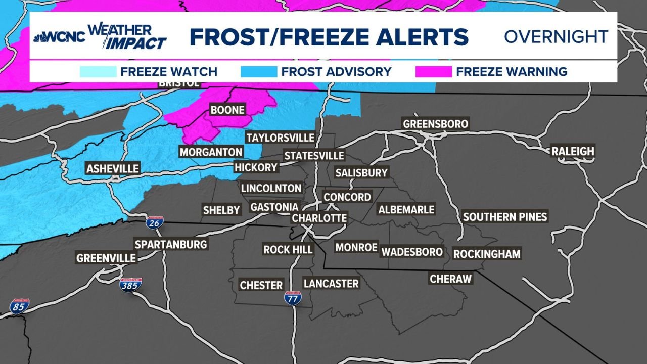
Alert Zones and Who Is Most at Risk
The most serious conditions overnight are concentrated in the North Carolina mountains, where Boone is under a Freeze Warning, the highest tier of cold weather alert. A Freeze Warning means temperatures are expected to drop to 32 degrees or below, and any unprotected plants, outdoor pipes and sensitive vegetation face direct damage. Boone is forecast to reach 32 degrees by Sunday at 6:00 AM, with nearby Jefferson dropping to 34 degrees and North Wilkesboro hitting 36 degrees.
Across the western Piedmont and foothills, a Frost Advisory covers communities including Hickory, Statesville, Morganton, Lincolnton, Gastonia and Shelby, where temperatures will fall cold enough for patchy to widespread frost formation on exposed surfaces. A Freeze Watch extends across portions of the region as well, signaling that freezing conditions remain possible as the cold air settles through the overnight hours.
In the Charlotte metro itself, temperatures are forecast to reach 40 degrees by Sunday morning at 6:00 AM. While that sits above the frost threshold, it represents a sharp plunge for early May and leaves little margin if the cold air arrives slightly stronger than projected.
How Rare Is a May Frost or Freeze in Charlotte
Historical records make clear just how unusual this weekend’s cold is for the Charlotte area. The average last freeze in Charlotte is March 28, meaning a freeze this close to mid-May falls more than five weeks past the typical end of freezing temperatures. The latest freeze on record for Charlotte occurred on May 2, 1963, a date this weekend’s forecast is approaching closely.
For frost, the numbers are similarly striking. The average last frost date in Charlotte is April 10, and the latest frost on record stretches all the way to May 18, 1973. Any frost or freeze threat arriving in May falls well outside what Charlotte residents typically plan for after the spring planting season is already underway.
Cities and Communities Facing the Coldest Temperatures
Sunday morning at 6:00 AM temperatures across the region tell a clear story of how widespread the cold will be. Starting from the mountains and moving through the Piedmont, the forecast lows are as follows. Bristol drops to 29 degrees, the coldest reading across the entire map. Boone reaches 32 degrees, sitting directly at the freeze threshold. Morristown falls to 33 degrees and Morganton to 35 degrees. Across the Piedmont, Statesville and Salisbury hit 37 degrees, Concord reaches 39 degrees and Greensboro drops to 40 degrees. Into South Carolina, Spartanburg falls to 42 degrees and Greenville holds near 39 degrees, cold enough to threaten frost on low-lying areas and exposed vegetation despite sitting above the technical freeze mark.
What Residents and Gardeners Should Do Tonight
- Bring potted plants, hanging baskets and any container gardens indoors or into a sheltered space before dark Saturday evening. Frost damage to tender plants can occur at temperatures as warm as 36 degrees under clear, calm and cloudless conditions.
- Cover in-ground garden beds, newly planted vegetables and fruit tree blossoms with frost cloth, old bed sheets or any breathable material that traps ground heat through the overnight hours.
- Residents in Boone and surrounding mountain communities under the active Freeze Warning should treat tonight with the same urgency as a late-winter freeze event, not a routine spring cold snap.
- Outdoor pets should be brought inside or provided with heated shelter for the entire overnight period.
- Check back Sunday morning before heading outdoors, as temperatures will recover through the afternoon and the frost threat will lift as sunshine returns across the region.
WaldronNews.com will continue tracking this late-season frost and freeze threat across North Carolina and South Carolina and will provide updates as overnight temperatures evolve through Sunday morning.