
Mississippi, Tennessee and Alabama Face Growing Wednesday Severe Weather Threat as 26.7% Storm Probability and 71-Degree Dewpoints Signal Dangerous Conditions
JACKSON, Mississippi — Confidence is rising that a significant severe weather outbreak will develop across the Mid and Deep South on Wednesday, May 6. Mississippi, Tennessee and Alabama sit directly in the highest-risk corridor as two jet stream energy sources phase together and amplify the threat. Surface moisture near 71 degrees Fahrenheit across Jackson confirms the atmospheric ingredients for a dangerous storm day are already locking in.
Why Wednesday’s Setup Is Being Taken Seriously
Two separate upper-level jet streams are forecast to phase, meaning they will merge and concentrate their combined energy into a single, more powerful system. When jets phase, upper-level wind speeds surge and storm support below increases dramatically.
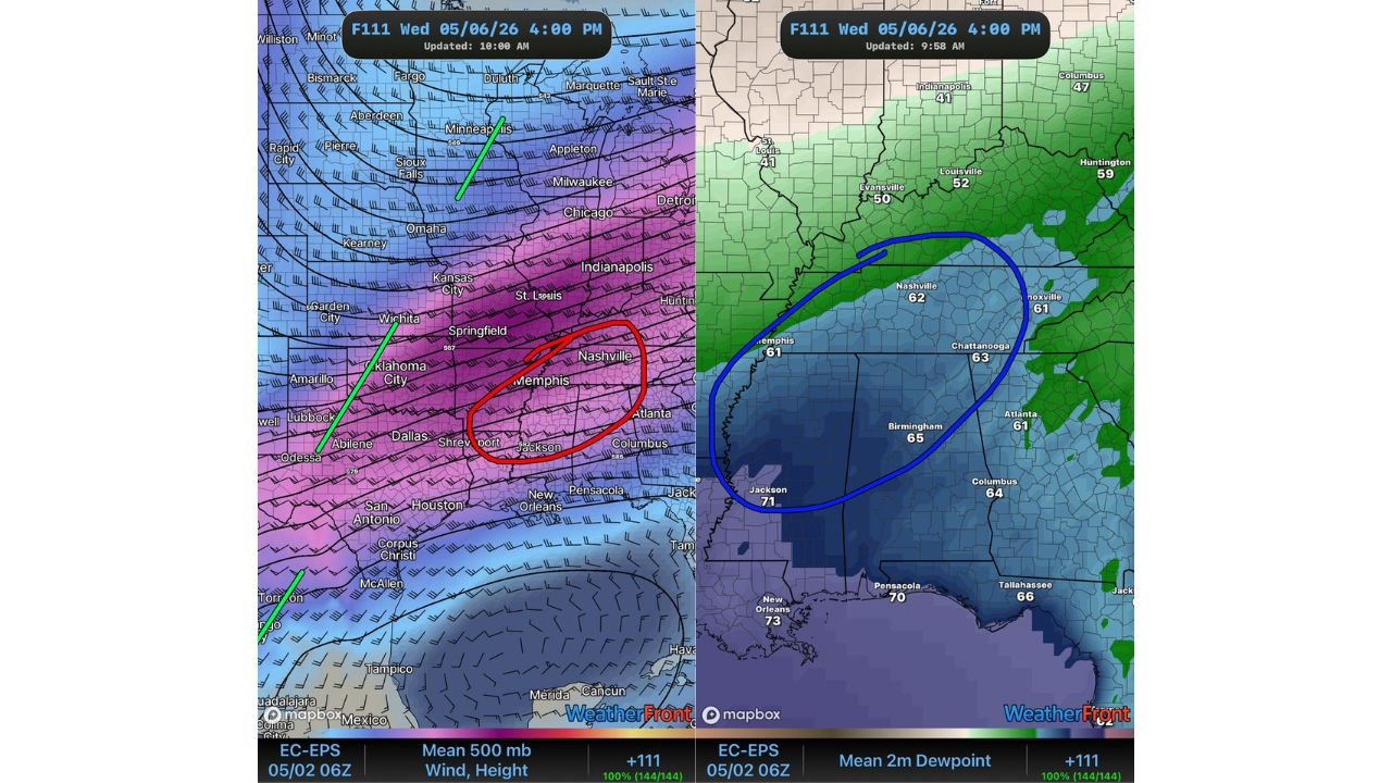
The highest-energy overlap zone currently targets a corridor covering Memphis, Tennessee, Jackson, Mississippi and Nashville, Tennessee. Both independent probability forecast systems now agree a severe weather event occurs Wednesday, with the maximum severe storm probability reaching 26.7 percent at five days out. That level of early agreement is significant.
Cities and States in the Primary Risk Zone
Mississippi
- Jackson dewpoint at 71 degrees, highest reading on the entire moisture map
- Central and northern Mississippi under greatest threat
- Key cities: Jackson, Tupelo, Meridian
Tennessee
- Memphis dewpoint at 61 degrees, Nashville at 62 degrees
- Red-circled focus area on upper-level wind map centers directly over the Memphis to Nashville corridor
- Both cities should expect Wednesday afternoon and evening threats
Alabama
- Birmingham dewpoint at 65 degrees, firmly inside the core moisture zone
- Chattanooga at 63 degrees, Columbus at 64 degrees also within the risk corridor
What the Two Probability Maps Show
Both forecasts cover the same 24-hour period ending early Thursday, May 7:
- First forecast places maximum probability at 26.7 percent with highest confidence over Kentucky and Tennessee, southern fringe extending into Mississippi and Alabama
- Second forecast focuses its highest probability tighter, directly over Mississippi and western Alabama
- Both systems agree severe weather will occur. Disagreement is only on exact placement, which is normal at five days out
What Makes This Setup Particularly Dangerous
- Dewpoints in the low 70s across southern Mississippi confirm aggressive Gulf moisture surging northward
- New Orleans, Louisiana hitting 73 degrees dewpoint shows how deep the moisture feed extends
- Strong wind shear from phasing jet streams overhead creates the environment for supercell thunderstorms
- Maximum instability and maximum wind shear are overlapping at the same location, the defining trait of the most dangerous severe weather setups
What to Watch Between Now and Wednesday
- Watch updated severe weather outlooks Sunday and Monday as forecasters narrow the risk zone with shorter-range guidance
- Key question: will storms fire as discrete supercells with the highest tornado threat, or will a squall line dominate with widespread damaging winds across a broader area
- Jackson, Mississippi sits at the intersection of highest moisture and highest probability. Residents there should act earliest
- Memphis and Nashville should prepare for possible severe weather Wednesday afternoon and evening
- All residents across Mississippi, Tennessee and Alabama should identify shelter locations and activate weather alert apps before Wednesday morning
WaldronNews.com will continue tracking this developing Mid-South severe weather threat and will provide updated coverage as Wednesday’s risk zone and timing sharpen through the early part of the week.