
Iowa, Missouri, Illinois and Indiana Face Marginal Risk of Severe Storms Monday as Thunderstorm Chances Spread Across the Entire Central United States
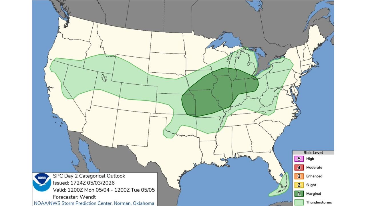
DES MOINES, Iowa — A Marginal Risk of severe thunderstorms has been issued for a broad corridor covering Iowa, Missouri, Illinois and Indiana for Monday, May 4 through Tuesday, May 5, 2026, with the darker shading on the outlook map indicating where organized storm activity and isolated severe weather are most likely. A much larger thunderstorm-only zone stretches from the Rocky Mountains east through the Great Plains and into the Ohio Valley, meaning rain chances will be widespread even for areas outside the formal severe weather risk.
The Core Risk Zone
The darkest shading on the map, representing the highest concentration of Marginal Risk, sits over a compact but meaningful zone centered across:
- Iowa — sits near the center of the darkest risk area
- Missouri — particularly northern and central portions
- Illinois — western and central sections
- Indiana — western portions fall within the risk zone
- Ohio — far western edge brushes the marginal area
This is a Level 1 out of 5 severe weather risk, meaning isolated severe storms are possible but a widespread or major outbreak is not expected. Damaging wind gusts, large hail and an isolated tornado cannot be ruled out within the darker shaded zone.
How Wide the Thunderstorm Threat Reaches
The broader light green thunderstorm zone on the outlook is notably large, stretching across much of the central United States. States that fall within the general thunderstorm area but outside the formal severe risk include Nebraska, Kansas, South Dakota, Wyoming, Colorado, New Mexico, Oklahoma and portions of Kentucky and Tennessee. These areas face rain and lightning but a lower threat of organized severe weather.
A small separate Marginal Risk area also appears along the southeastern Florida coast, disconnected from the main central US system.
What Monday’s Storms Could Produce
Within the Iowa, Missouri, Illinois and Indiana core zone, any storms that develop could produce:
- Damaging wind gusts as the most likely severe hazard given the storm mode expected
- Large hail with any stronger individual cells
- An isolated tornado cannot be completely ruled out, particularly if discrete supercell storms develop ahead of any linear system
The timing and exact placement of the most organized storm activity will sharpen through Sunday night and Monday morning as the system moves into range of shorter-term forecasting tools.
What Residents Should Know Before Monday
Residents across Iowa, Missouri, Illinois and Indiana should have a weather alert method ready before Monday afternoon. This is not a high-end or dangerous outbreak setup, but isolated severe weather in a Marginal Risk environment can still produce significant damage in localized areas with little warning.
WaldronNews.com will continue tracking Monday’s storm threat across Iowa, Missouri, Illinois and Indiana and will provide updated coverage as the day approaches.