
Three Separate Weather Threats Active Across the United States Sunday as Severe Storms Hit Mississippi Valley, Flash Flooding Targets Florida and Fire Danger Rises in North Dakota and Montana
WASHINGTON, D.C. — Three entirely separate and simultaneous weather threats are unfolding across the United States on Sunday, May 3, 2026, affecting communities from the Gulf Coast to the Northern Plains. Isolated severe storms are firing across the Mississippi Valley this evening, thunderstorm clusters are pushing flash flooding risks across the Florida peninsula, and an Elevated fire weather threat has been issued across North Dakota and northern Montana where dry and windy conditions are creating dangerous wildfire conditions.
Severe Storms: Mississippi Valley This Evening
Isolated severe thunderstorms capable of hail and gusty winds are possible across portions of the mid-Mississippi Valley through Sunday evening. The threat is not widespread but isolated cells could produce:
- Large hail with the strongest individual storms
- Gusty and damaging winds as storms move through
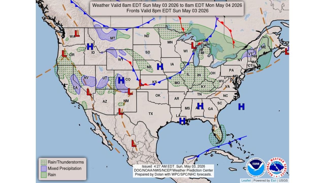
- Arkansas, Missouri and Tennessee are the primary states in this evening’s storm corridor based on the surface weather map showing a low pressure and frontal boundary draped across the region
This is an isolated and not a widespread severe weather event but residents across these states should keep an eye on radar through the evening hours.
Flash Flooding: Florida Peninsula
Clusters of thunderstorms are pushing across the Florida peninsula Sunday, bringing the potential for isolated flash flooding in areas that receive repeated rounds of heavy rainfall. The southern Florida coast and peninsula are highlighted on the surface weather map with a separate low pressure system pulling moisture onshore from the Gulf of Mexico and Atlantic simultaneously.
Residents across central and southern Florida should avoid flood-prone roads and low-lying areas through Sunday evening as storms continue moving through.
Elevated Fire Weather: North Dakota and Montana
The most geographically isolated threat of the three sits across northern Montana and North Dakota, where a Level 1 Elevated fire weather risk has been issued for Sunday, May 3 through Monday morning, May 4. The orange-shaded zone covers a broad swath of the northern border states where dry conditions, low humidity and gusty winds are combining to create conditions where any ignition could spread rapidly.
This is not a Critical or Extreme fire weather day but Elevated means conditions are dangerous enough that any outdoor burning should be avoided entirely across northern Montana and North Dakota through Monday morning.
The Bigger Picture Sunday
The national surface weather map shows a complex and active pattern with multiple low pressure systems across the West, a strong frontal boundary draped from Kansas through the Ohio Valley, and high pressure anchored across the Southeast keeping that region relatively quiet. The bulk of the active weather is concentrated along and ahead of the main frontal system pushing eastward through the central United States.
WaldronNews.com will continue tracking all three active weather threats across the Mississippi Valley, Florida and the Northern Plains and will provide updates as conditions develop through Sunday evening.