
Texas, Louisiana, Mississippi and Alabama Face Severe Weather Threat Wednesday as Houston, Jackson, Tupelo and Birmingham Enter the Risk Zone for May 6
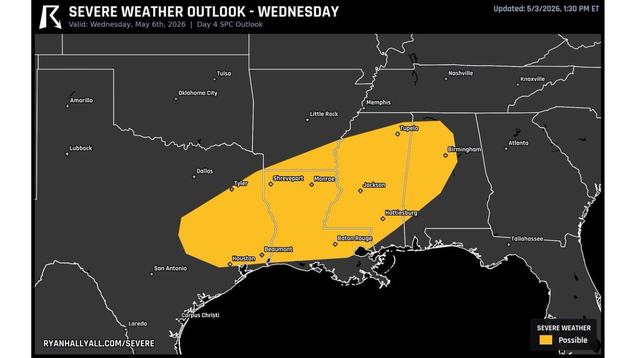
JACKSON, Mississippi — A severe weather outlook covering a wide swath of the Gulf South has been issued for Wednesday, May 6, 2026, placing Texas, Louisiana, Mississippi and Alabama under a possible severe weather zone that stretches from Houston northeast through Shreveport, Monroe, Jackson, Hattiesburg, Tupelo and Birmingham. The outlook was updated May 3 at 1:30 PM ET and represents a Day 4 look at a system forecasters have been watching build confidence through the week.
Who Is Inside the Risk Zone
The yellow shading on the outlook map covers a large and well-defined corridor across four states. Cities sitting directly inside the severe weather possible zone:
Texas: Houston, Beaumont, Tyler
Louisiana: Shreveport, Monroe, Baton Rouge
Mississippi: Jackson, Hattiesburg, Tupelo
Alabama: Birmingham
The risk zone is elongated southwest to northeast, which is a classic orientation for a system where a strong jet stream and surface boundaries combine to fire storms along a focused corridor through the Deep South.
What Wednesday Could Bring
This is currently labeled severe weather possible, meaning the atmospheric setup supports organized storm development but specifics on storm mode, exact placement and timing are still being refined at four days out. Given what upper-level wind data and moisture maps have already shown for this date, the ingredients in place support:
- Supercell thunderstorms capable of tornadoes and large hail across the core of the risk zone
- Damaging straight-line winds particularly if storms organize into a line later in the event
- The Jackson to Tupelo corridor in Mississippi and Birmingham, Alabama sitting near the northeastern edge where shear values are most favorable for rotating storms
Why This Week Keeps Coming Back to Wednesday
This is now the third separate data source pointing to Wednesday, May 6 as the significant severe weather day across the Gulf South. Upper-level wind data showed a powerful jet phasing over the Memphis to Jackson corridor. Probability maps placed the highest confidence zone over Mississippi and Alabama. Now a Day 4 outlook formally draws the risk zone across the same geography. That level of consistency across multiple independent sources at four days out is meaningful and should not be ignored by residents across these states.
Houston and Beaumont, Texas residents are now formally inside a risk area for the first time in this week’s coverage, representing a westward extension of the threat that adds millions more people to the zone worth watching.
WaldronNews.com will continue tracking Wednesday’s severe weather threat across Texas, Louisiana, Mississippi and Alabama and will provide daily updates as May 6 approaches.