
Mississippi and Louisiana Face Up to 40 to 50 Percent Tornado Probability Wednesday as Elevated Threat Zone Targets the Heart of the Deep South on May 6
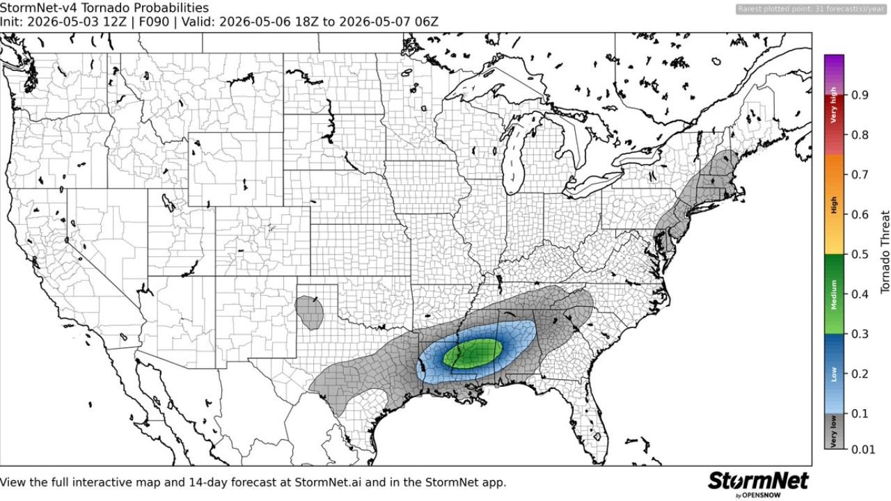
JACKSON, Mississippi — A tornado probability forecast initialized Sunday morning, May 3, 2026 places Mississippi and Louisiana inside an elevated to medium tornado threat zone for Wednesday, May 6, with the highest probability values reaching the green shading band representing 40 to 50 percent tornado likelihood across a concentrated core centered over the two states. The forecast covers the period from Wednesday evening through early Thursday morning, a window that falls squarely in the most dangerous overnight hours for this region.
What the Probability Map Shows
The tornado probability is organized in three concentric zones spreading outward from the highest-risk core:
Core Zone — Green Shading (40 to 50% probability) Centered directly over central Mississippi and northeastern Louisiana, this is the area where tornado development is considered most likely during the Wednesday evening window. Jackson, Mississippi sits near or inside this zone.
Middle Zone — Blue Shading (20 to 30% probability) A broader ring extending outward covers a larger portion of Mississippi, Louisiana, southern Tennessee and southwestern Alabama. Cities including Shreveport, Louisiana, Memphis, Tennessee and Hattiesburg, Mississippi fall within this zone.
Outer Zone — Gray Shading (Low but non-zero probability) Spreads across a wide area from eastern Texas through Alabama and Tennessee, representing a lower but meaningful tornado threat across the broader region.
Why This Forecast Matters
This is now the fourth consecutive data source confirming Wednesday, May 6 as a significant severe weather day across the Deep South. What makes this particular product notable is that it specifically isolates the tornado threat rather than general severe weather, and places the highest confidence directly over Mississippi and Louisiana rather than spreading it across a vague multi-state zone.
A 40 to 50 percent tornado probability at four days lead time is a serious signal. Most significant tornado outbreaks in this region do not reach those probability values until the day before or the morning of the event.
The Overnight Timing Problem
The valid period of Wednesday 18Z through Thursday 06Z translates roughly to Wednesday afternoon through Wednesday overnight into early Thursday morning. The trailing portion of this window, from roughly midnight through 6 AM Thursday, represents the highest-risk time for nocturnal tornadoes when:
- Most residents across Mississippi and Louisiana are asleep
- Outdoor warning sirens may not be heard indoors
- Visual confirmation of tornado development is impossible in darkness
- Warning lead times feel shorter because reaction time is slower
Residents across Jackson, Hattiesburg, Shreveport and Monroe should have a battery-powered weather radio or phone alert system active through Wednesday night, not just Wednesday afternoon.
WaldronNews.com will continue tracking the Wednesday tornado threat across Mississippi and Louisiana and will provide updated coverage daily as May 6 approaches.