
Arkansas Tornado Threat Stays Mostly Quiet Tuesday Evening but Western Arkansas Storm Development Later Tonight Could Still Produce Severe Weather Near Russellville and Batesville
LITTLE ROCK, Arkansas — The much-anticipated northern Arkansas tornado and hail threat has largely failed to materialize through Tuesday evening, with storms developing on the northern fringe of the instability zone rather than tapping into the richest CAPE and producing the organized supercells forecasters were watching for. However, the event is not over. Additional storm development is possible later tonight across western Arkansas, and those storms could have a better chance at becoming severe or tornadic than what has unfolded so far.
Why the Northern Threat Did Not Develop as Expected
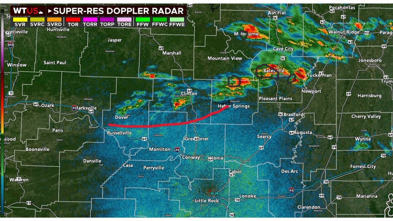
Storms that fired across northern Arkansas near Batesville, Cave City and Walnut Ridge developed along the northern edge of the CAPE plume, essentially right along the sagging cold front rather than ahead of it in the richer instability. When storms form on the boundary itself rather than in the warm sector ahead of it, their tornado and hail potential is significantly reduced.
An outflow boundary is already visible on radar, shown as the red curved line stretching from near Dover and Russellville east toward Heber Springs. That boundary marks where earlier storm downdrafts have pushed cool air outward along the surface. Outflow boundaries can either trigger new storm development or disrupt existing cells depending on how they interact with the environment.
The outlined storm cells near Batesville on radar represent storms being watched for a potential downstream tornado watch if they become surface-based, but that transition appears unlikely at this time.
What the Mesoscale Data Shows
The surface-based CAPE analysis shows a large zone of instability across Arkansas, Louisiana and Mississippi, with values reaching 1,500 to 2,500+ J/kg across the region. The instability is present but the storms so far have not been able to tap into it effectively due to their position along the boundary.
The 850 mb temperature and wind analysis shows the low-level jet strengthening across Arkansas and Tennessee, with winds exceeding 25 knots in the hatched zone covering Tennessee, Kentucky and the mid-South. This low-level jet enhancement will continue through the overnight hours, which is the atmospheric ingredient most responsible for any late-evening or nighttime tornado development that could still occur.
The Western Arkansas Wildcard
Storm development is possible later this evening across western Arkansas, in the area near Russellville, Clarksville and the Arkansas River Valley. These storms would be developing in a different location than the northern cells, potentially in a more favorable position relative to the instability and the low-level jet. If any cell in western Arkansas can mature and stay discrete tonight, the environment still supports severe hail and an isolated tornado.
This remains a watch and wait situation through the late evening hours.
WaldronNews.com will continue tracking storm development across Arkansas through Tuesday night and will provide updates as the western Arkansas storm potential evolves.