
Significant Tornado and Very Large Hail Targeting Central and Northeast Arkansas Including Little Rock and Surrounding Areas This Afternoon Into Tonight
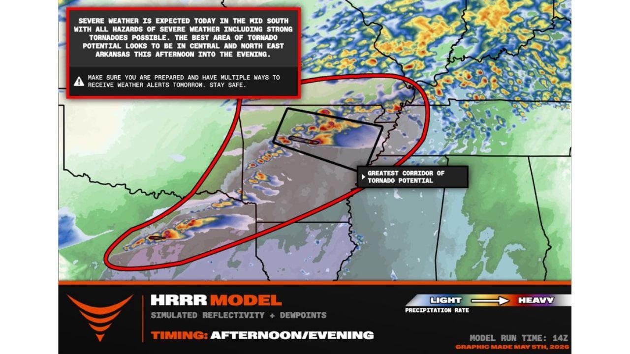
LITTLE ROCK, Arkansas — A significant tornado or two are now possible this evening across Arkansas, including the Little Rock area. Supercells are forecast to erupt northwest of Little Rock by 5 PM, capable of producing tornadoes and very large hail. The greatest corridor of tornado potential is focused on central and northeast Arkansas this afternoon into the evening, with the threat window running through tonight.
Where the Greatest Tornado Risk Is Focused
- Central Arkansas including the Little Rock area sits directly in the highest-risk corridor
- Northeast Arkansas carries equal concern through the evening hours
- The black-box corridor on HRRR model simulated reflectivity marks the greatest concentration of tornado potential
- The broader red-outlined zone covers additional portions of the Mid-South where all severe hazards remain possible
What Is Expected and When
- Supercell initiation: northwest of Little Rock by 5 PM
- Primary threat window: afternoon into evening
- Model run: 14Z May 5, 2026 HRRR simulated reflectivity with dewpoints
- Severe weather is expected across the Mid-South with all hazard types in play
Primary Threats With Any Mature Supercell
- Significant tornadoes — a tornado or two are explicitly possible, with strong tornadoes not ruled out in the highest-risk corridor
- Very large hail — supercells erupting into this environment carry hail as a co-equal threat
- Damaging straight-line winds — with any organized and sustained cell
This threat is consistent with the atmospheric data already in place. Tonight’s forecast sounding for Little Rock showed a Supercell Composite of 31, a fixed-layer Significant Tornado Parameter of 2.6, and a Critical Angle of 79 degrees — all values that directly support what is now being highlighted. The SARS analog database returned a 73 percent match for supercell storm types for this environment.
What Arkansas Residents Must Do Right Now
- Confirm you have multiple ways to receive weather alerts before 5 PM. Wireless Emergency Alerts on your phone, a NOAA weather radio, and a local TV app are the three minimum layers.
- Identify your shelter location now, not when warnings are issued. Interior rooms on the lowest floor, away from windows, are the standard guidance for tornado shelter.
- Do not rely on visual confirmation of a tornado. Nighttime and rain-wrapped tornadoes in this environment can be completely invisible until they are immediately overhead.
- Monitor radar at the county scale after 4 PM. Scattered supercell mode means one storm over one county can be the entire event. Watch individual cells, not regional trends.
- Stay sheltered until warnings expire. A single supercell can produce multiple tornadoes along a long track.
Timing Summary
- 4 PM to 5 PM: Watch for supercell initiation northwest of Little Rock
- 5 PM to 9 PM: Highest tornado and large hail risk across central Arkansas
- 9 PM to midnight: Continued threat into northeast Arkansas as storms track east
- Stay weather-aware until at least midnight
WaldronNews.com will continue tracking this tornado threat across central and northeast Arkansas and will provide updates as storms develop and warnings are issued this evening.