
Arkansas and Neighboring States Face Supercell Threat Tonight With Large Hail and Tornadoes as Setup Mirrors Deadly April 2022 Outbreak
LITTLE ROCK, Arkansas — A supercell-capable severe weather pattern is setting up across Arkansas and neighboring states this evening. Atmospheric data from Little Rock draws direct comparisons to the April 11, 2022 outbreak that produced 69 large hail reports and 9 tornadoes across the lower Mississippi Valley. Today’s wind shear is actually stronger than April 2022, though instability runs somewhat lower. Any robust supercell that fires tonight and matures into the overnight hours carries all severe hazard types.
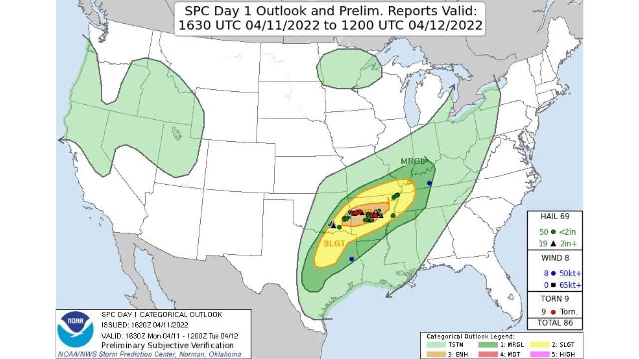
Why Tonight Mirrors April 11, 2022
The April 11, 2022 event verified as follows:
- 69 hail reports across the region
- 9 confirmed tornadoes
- 8 damaging wind reports
- Moderate Risk area centered on Arkansas, Mississippi, and Tennessee
- Storms were isolated to widely scattered supercells, giving each cell room to fully organize
The observed Little Rock sounding after that event showed:
- Supercell Composite Parameter: 13.6
- Effective-layer Storm-relative Helicity: 738 m2/s2
- Significant Tornado Parameter (fixed-layer): 3.2
- Surface-based CAPE: 3,429 J/kg (joules per kilogram, the measure of atmospheric fuel available to storms)
What Tonight’s Data Shows for Little Rock
Tonight’s forecast sounding for Little Rock produces these key numbers:
- Mixed-layer CAPE: 1,842 J/kg — substantial thermodynamic energy, lower than 2022 but still significant
- Lifted Condensation Level: 487 meters — a low cloud base that strongly favors tornado formation when rotation develops
- Critical Angle: 79 degrees — very close to the ideal 90-degree value for supercell and tornado-producing wind alignment
- BRN Shear: 88 knots squared — strong rotational support for sustained storms
- EF Shear (effective layer): 43 knots — supports significant tornado potential in organized cells
- Significant Tornado Parameter (fixed-layer): 2.6
- Supercell Composite: 31
- Significant Hail Parameter: 1.1 — large hail firmly on the table
SARS analog matching returns a 73 percent match for supercell storm types, meaning the atmosphere tonight strongly favors discrete rotating storms over disorganized convection.
Cities and Areas in the Threat Zone
- Central Arkansas including Little Rock and the KLZK corridor carry the highest concern
- Eastern Arkansas communities sit within the supportive environment zone
- Adjacent Mississippi and Tennessee fall within reach of organized cells tracking east
- Southern Missouri holds a secondary risk depending on storm track
The scattered storm mode is critical context here. Individual cells will not compete with neighboring storms for available energy, meaning any supercell that fires could tap the full shear and instability environment without interference.
Primary Threats Tonight
- Large to very large hail — potentially exceeding 2 inches in diameter based on the Significant Hail Parameter and effective-layer EF Shear
- Tornadoes — most likely brief and weak, but EF2 or stronger is possible if a storm fully exploits the low LCL and available wind shear
- Damaging straight-line winds — with the most organized and mature supercells, consistent with the 2022 analog pattern
Timing to Know
- Storm initiation expected this afternoon through evening
- Most dangerous window: late evening into overnight
- Threat continues until at least midnight
- Lower instability compared to 2022 means storm initiation will be selective, but any storm that fires has full shear infrastructure available
What to Watch Tonight
- Watch for supercell initiation across central Arkansas this afternoon. Any storm developing a rotating updraft in this environment has the tools to become dangerous quickly.
- Monitor the tornado threat specifically after dark. Nighttime tornadoes are the hardest to see and carry the least warning time. Low LCL values and strong helicity make this the highest-concern window.
- Hail of 2 inches or larger is possible. The 2022 analog produced large hail as the dominant storm report type and tonight’s parameters support the same outcome.
- Track individual cells on radar, not the regional picture. Scattered coverage means one storm over one county can be the entire event. County-scale radar monitoring is more useful than watching broad regional trends.
- Stay weather-aware until at least midnight. Fast-moving overnight storms carry limited visual warning time.
WaldronNews.com will continue tracking this severe weather pattern across Arkansas and the surrounding region and will provide updates as storm initiation and development become clearer through the evening.