
Florida, Georgia, Alabama and Tennessee Face Hurricane Irma’s 100 mph Winds and Deadly Flooding as Storm Tracks North From Tampa to Memphis Through Wednesday
TAMPA, Florida — Hurricane Irma made its presence felt across Florida and the broader Southeast on Sunday night, September 10, 2017, with maximum sustained winds of 100 mph and a center location at 27.5 degrees North, 81.9 degrees West as of the 11 PM EDT Advisory 48 from the National Hurricane Center. The storm was moving north at 14 mph, with its track projected to carry it through Georgia and into Tennessee and Kentucky before weakening into a depression by Wednesday.
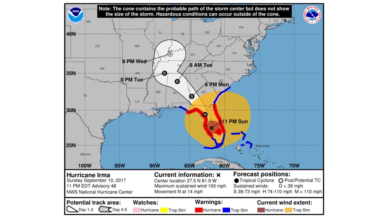
What the Cone Does Not Tell You
One of the most dangerous misconceptions about any hurricane forecast is that the cone represents the size of the storm. It does not. The cone shows only the probable path of the storm center. Deadly hazards extend well outside the cone in every direction, including far inland and in areas that never see the center pass overhead. Hurricane Irma demonstrated this directly, with a wind field that stretched well beyond the cone boundaries at every stage of its track.
Irma’s Forecast Track as of 11 PM Sunday
- 11 PM Sunday: Center near 27.5 North, 81.9 West — Hurricane status, 100 mph sustained winds
- 8 PM Monday: Tracking northeast toward the Georgia and South Carolina coast — still at Hurricane strength
- 8 AM Tuesday: Approaching the Tennessee Valley corridor — weakening to Subtropical status
- 8 PM Tuesday: Pushing into Arkansas and Missouri — Depression level
- 8 PM Wednesday: Dissolving over the central United States
Wind Zones at Time of Advisory
- Hurricane force winds (74 to 110 mph): Immediate Florida peninsula corridor
- Tropical Storm force winds (39 to 73 mph): Extending across Georgia, South Carolina and into North Carolina
- Tropical Storm watch zone (under 39 mph): Reaching into Alabama, Mississippi and portions of Tennessee
Why Inland Residents Cannot Ignore This Storm
Irma’s wind field at this advisory extended across the entire Florida peninsula and well into Georgia simultaneously. Residents in Alabama, Mississippi, Tennessee and even Arkansas sat within the potential impact zone for tropical storm force winds, flooding rainfall and tornadoes spawned by the outer bands — none of which required the storm center to pass directly overhead.
What to Watch as Irma Tracks North
- Tornadoes are possible well ahead of the center in the outer rainbands across Georgia, South Carolina and southern North Carolina through Monday
- Rainfall flooding will be the primary inland threat across Alabama, Tennessee and Arkansas as the weakening system pushes moisture northward through Tuesday and Wednesday
- Wind damage is not limited to the cone — any area within the tropical storm wind extent circle faces downed trees and power outages regardless of forecast track shifts
- Storm surge remains life-threatening along any coastline where onshore winds persist, even after the center moves inland
- Track shifts of even 50 miles can move hurricane force winds into areas currently outside warning zones — monitor updates every six hours
WaldronNews.com will continue tracking Hurricane Irma and provide updates as the storm moves north through Florida, Georgia and into the Tennessee Valley through midweek.