
Preliminary EF4 Tornado Confirmed in Franklin County Mississippi With 183 mph Winds and Debris Lofted to 25,000 Feet Along Long Track From Darrington to Meadville
MEADVILLE, Mississippi — A preliminary EF4 or stronger tornado tore through Franklin County, Mississippi Wednesday evening, with radar data showing a rotational velocity of 74.0 knots and debris lofted to more than 25,000 feet above the ground. The rating is preliminary and pending official ground surveys by the National Weather Service Jackson office, but intensity probability calculations based on the radar data place the likelihood of EF4 or greater at 89.11 percent with an expected peak wind speed of 183.3 mph.
What the Radar Data Showed
- Rotational velocity: 74.0 knots — used as the primary input for intensity calculations after the 95 knot reading was flagged as likely not credible
- Debris lofted to 25,000 feet plus — detected by correlation coefficient signatures indicating large lofted debris within the tornado vortex
- Intensity probability breakdown:
- EF0: 0.00%
- EF1: 0.08%
- EF2: 0.40%
- EF3: 10.41%
- EF4 or greater: 89.11%
- Expected peak wind speed: 183.3 mph
The Tornado Track
The red line across the satellite imagery shows a long and continuous track stretching from the Darrington and Perrytown area in the southwest through Knoxville and Franklin toward Bunkley and Meadville in the northeast. The track crosses the Homochitto River corridor through Franklin County covering a significant distance through rural southwest Mississippi. The full length of the track is still being assessed pending NWS ground surveys.
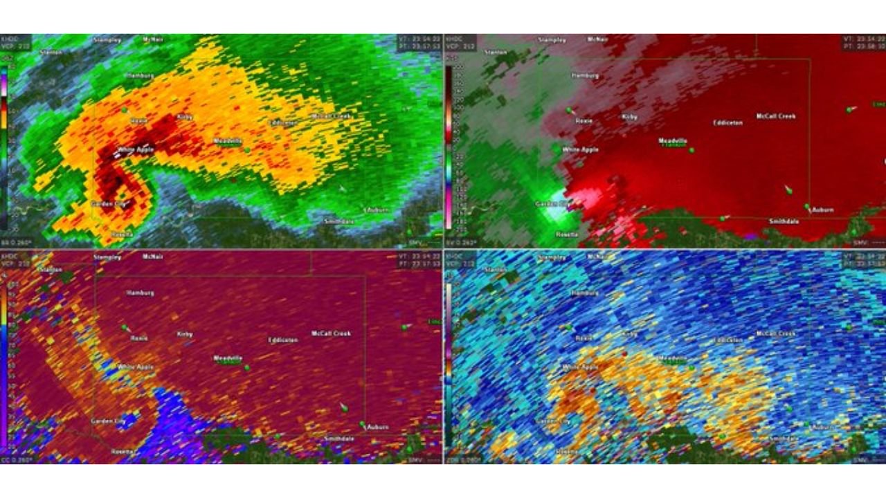
What the Radar Showed at 10:54 PM CDT
The four-panel KHDC Hammond radar display at 10:54 PM CDT captured the tornado at or near peak intensity:
- Velocity panel: Extreme gate-to-gate shear with deep purple inbound and bright red outbound velocities tightly collocated near White Apple and Meadville — a textbook violent tornado radar signature
- Correlation coefficient panel: Near-zero CC values in the core of the circulation near Meadville indicating a large and well-defined debris ball — debris was lofted high enough and in large enough quantities to register clearly on dual-polarization radar
- Spectrum width panel: Extremely high spectrum width values across the entire circulation indicating chaotic and violent wind fields within the vortex
- Reflectivity: Hook echo structure clearly defined with a bounded weak echo region indicating an extremely powerful rotating updraft
Why This Rating Is Preliminary
Ground surveys by the National Weather Service Jackson office are required before any official EF-scale rating is assigned. Radar-derived intensity estimates based on rotational velocity and debris height are scientific tools that provide strong guidance but do not replace physical damage assessment. The 89.11 percent probability of EF4 or greater makes this one of the stronger preliminary indications possible from radar data alone, but the final rating will depend on what surveyors find on the ground across the Franklin County track.
What Franklin County Residents Need to Know
- Anyone in the path of this tornado from Darrington through Meadville should check on neighbors immediately — rural tracks through areas like Franklin County can cause catastrophic damage with little to no warning time for residents
- Do not enter heavily damaged structures until they are inspected — EF4-level winds cause structural failures that make buildings unsafe even when they appear to be standing
- Roads through the track area may be blocked by debris, downed power lines and damaged bridges across the Homochitto River corridor
- Report damage to the National Weather Service Jackson office to assist with the ground survey and official rating process
WaldronNews.com will continue tracking the Franklin County tornado survey and damage reports across southwest Mississippi and will provide updates as the National Weather Service completes its assessment.