
Texas, Mississippi, Alabama and Tennessee Face EF2 Tornadoes, Large Hail and Significant Flash Flooding Tonight From Eastern Texas Through the Tennessee Valley and Southern Appalachians
JACKSON, Mississippi — Strong to severe thunderstorms will continue this evening from eastern Texas into the lower Mississippi and Tennessee Valleys and southern Appalachians, with the strongest storms capable of producing EF2 or stronger tornadoes, damaging wind gusts, large hail and locally heavy to excessive rainfall. A Moderate Risk for flash flooding, level 3 out of 4, has been issued through overnight for central and southern Alabama and Mississippi where flash flooding is likely and some flooding events could be significant.
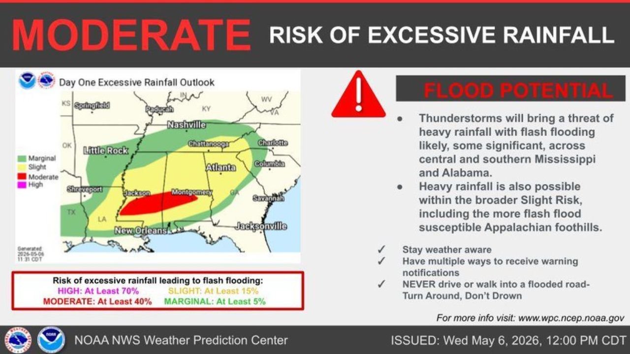
Who Faces the Highest Flash Flood Risk Tonight
- Moderate Risk — at least 40% chance: Central and southern Mississippi including Jackson and Hattiesburg, extending into central and southern Alabama through Montgomery
- Slight Risk — at least 15%: Broader zone covering Little Rock, Shreveport, New Orleans, Nashville, Chattanooga, Atlanta and the Appalachian foothills corridor toward Charlotte
- Marginal Risk — at least 5%: Outer fringe stretching from eastern Texas through Tennessee and into the Carolinas
Primary Threats With the Strongest Storms
- EF2 or stronger tornadoes possible with the most organized supercells from eastern Texas through Mississippi and Alabama
- Damaging wind gusts with any severe thunderstorm across the entire corridor
- Large hail accompanying the strongest rotating cells
- Flash flooding likely across central and southern Mississippi and Alabama with some flooding events expected to be significant overnight
- Appalachian foothills carry additional flash flood concern due to terrain that funnels water rapidly into narrow valleys and creeks
Why Flooding Is the Overnight Priority
Thunderstorms training over the same locations repeatedly through the overnight hours will stack rainfall totals across an area already holding exceptional moisture. The Moderate Risk zone covering Jackson through Montgomery sits at the center of the heaviest rainfall footprint. Significant flash flooding means events that go beyond typical street flooding and include rapidly rising creeks, structural flooding and road closures that persist into Thursday morning.
What to Do Right Now
- Never drive or walk into a flooded road — turn around, do not drown. Water depth on roads is impossible to judge at night
- Stay weather aware through the entire overnight period — tornado and flash flood warnings can be issued simultaneously in this environment
- Have multiple ways to receive warning notifications active on your phone before you go to sleep tonight
- Residents near creeks and streams in central Mississippi and Alabama should identify higher ground they can move to quickly if flooding begins overnight
- Southern Appalachian foothills communities face terrain-driven flash flooding risk even in the Slight Risk zone — do not discount the threat based on being outside the Moderate zone
WaldronNews.com will continue tracking severe thunderstorm and flash flood warnings across Mississippi, Alabama and the Tennessee Valley and will provide updates through the overnight hours.