
Flash Flooding Threat Covers Jackson, Hattiesburg and Montgomery as Heavy Rain Trains Over the Same Areas Across Southeast Mississippi and South-Central Alabama Today
JACKSON, Mississippi — A Moderate Risk for flash flooding, rated level 3 out of 4, is in place from southeast Mississippi into south-central Alabama today. Heavy rain is expected to train repeatedly over the same locations across the Jackson, Hattiesburg and Montgomery corridor, meaning the same streets, neighborhoods and low-lying areas will receive multiple rounds of heavy rainfall with little time to drain between storms. Dewpoints in the low to mid 70s and precipitable water values over 2 inches are in place, creating an atmosphere that will wring out heavy rainfall very efficiently.
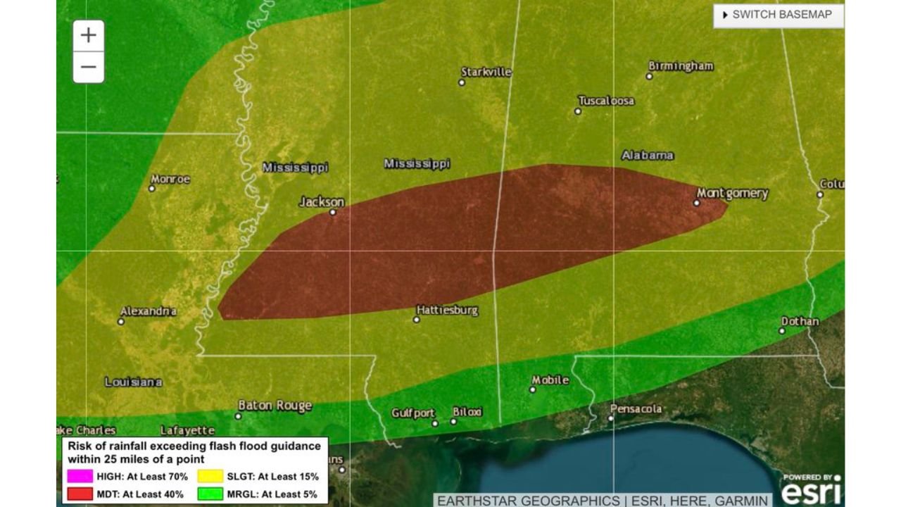
Who Faces the Highest Flash Flood Risk
- Moderate Risk — at least 40% chance of flash flooding within 25 miles: Jackson through Hattiesburg corridor across central and southeast Mississippi, extending into Montgomery and south-central Alabama
- Slight Risk — at least 15% chance: Broader zone covering Starkville, Tuscaloosa, Mobile, Biloxi, Gulfport and Baton Rouge
- Marginal Risk — at least 5% chance: Outer fringe covering Monroe, Alexandria, Lafayette and the Florida panhandle toward Pensacola and Dothan
Why the Flooding Risk Is Elevated
- Precipitable water values over 2 inches — the atmosphere is holding an exceptional amount of moisture that storms will convert directly into heavy rainfall
- Dewpoints in the low to mid 70s — extremely humid air at the surface feeds storms continuously as they develop
- Training convection — storms are expected to move along the same path repeatedly, stacking rainfall totals over the same neighborhoods and roads rather than spreading rain over a wide area
- Widespread convection — rainfall will not be isolated to a few cells but spread across the entire Moderate Risk zone simultaneously
What Flash Flooding Means on the Ground
When storms train over the same areas, creeks and streams rise faster than drainage systems can handle. Roads flood quickly even in areas that do not typically flood. Underpasses, low water crossings and drainage ditches fill with little warning. The combination of over 2 inches of precipitable water and training storm motion means some locations within the Moderate Risk zone could receive 3 to 5 or more inches of rain in just a few hours.
What Residents Must Do Today
- Never drive through flooded roads — water depth on roads is impossible to judge visually and even 12 inches of moving water can sweep a vehicle off the road
- Avoid low-lying areas, creek banks and flood-prone neighborhoods throughout the day and into the evening
- Have multiple ways to receive flash flood warnings on your phone — wireless emergency alerts, a weather app and local TV notifications are the three minimum layers
- Move vehicles to higher ground before storms arrive if you park near flood-prone areas
- Check on elderly neighbors who may not receive or respond quickly to flash flood warnings
WaldronNews.com will continue tracking flash flood warnings and rainfall totals across Mississippi and Alabama and will provide updates as storms develop and flooding reports come in throughout the day.