
Why Southern Mississippi Including Brookhaven, McComb and Hattiesburg Is the Most Tornado-Prone Place on Earth and What That Means After Wednesday Night
BROOKHAVEN, Mississippi — Southern Mississippi and Alabama represent the most tornado-prone place on Earth in terms of total tornado path length and width, surpassing even the conventional Tornado Alley of Oklahoma and Kansas. Average tornado path lengths in this region run slightly longer than those seen across the central Plains, and southern Mississippi and Alabama hold the top spot in virtually every measure of tornado danger. Wednesday night’s violent tornado outbreak near Brookhaven, McComb and Hattiesburg was not a random event in an unlikely place. It happened in the most statistically dangerous tornado corridor on the planet.
Why This Region Produces the Worst Tornadoes
- Longest average tornado path lengths in the world — tornadoes here travel further on the ground than anywhere else, meaning more communities in the direct path of a single storm
- Greatest total path width — tornadoes in this corridor are wider on average than those in Tornado Alley, increasing the area of catastrophic destruction with each event
- Southern Mississippi and Alabama are the hotspot of virtually every sinister tornado metric — frequency, intensity, path length, path width and nighttime occurrence all peak in this region
- The Brookhaven, McComb and Hattiesburg corridor has been a violent wedge tornado magnet for at least the last 15 years, attracting some of the most dangerous storms on record repeatedly across the same geography
Why This Area Is More Dangerous Than Tornado Alley
The conventional Tornado Alley across Oklahoma, Kansas and Texas gets more attention and more storm chaser coverage, but the numbers tell a different story. Tornadoes in southern Mississippi and Alabama tend to be longer-tracked, wider and more likely to occur at night when residents are asleep and warning response times are slower. The terrain, which lacks the flat open farmland of the Plains, means tornadoes here are frequently rain-wrapped and invisible until they are immediately overhead. Trees and hills further obscure visual detection and make shelter options more limited for rural residents.
What Wednesday Night Confirmed
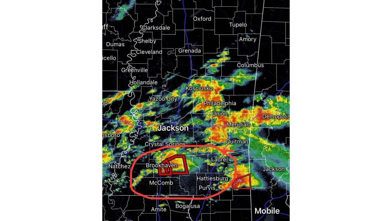
The preliminary EF4 tornado through Franklin County with a long track from Darrington through Meadville, combined with the violent rotation signatures near Brookhaven and the active tornado warnings near Hattiesburg and Purvis, is exactly the kind of event this region’s climatology predicts. The radar at 6:24 PM CDT showed simultaneous warning boxes over Brookhaven and Hattiesburg — two separate dangerous cells operating in the same corridor within the same hour. That is not coincidence. That is what happens when the atmosphere activates over the most tornado-prone geography on Earth.
What Southern Mississippi Residents Must Understand
- Living in this corridor means tornado preparedness is not optional — this region produces violent and long-tracked tornadoes more reliably than anywhere else in the world
- Nighttime tornadoes are the greatest risk — the majority of tornado fatalities in this region occur overnight when people are asleep and have no visual warning
- A weather alert on your phone is not enough — a NOAA weather radio with a battery backup is essential for overnight warning reception when phone alerts may not wake you
- Mobile homes and older wood-frame structures provide no meaningful protection from an EF4 tornado — knowing your nearest permanent shelter location before storm season is a life-safety decision
- The 15-year pattern of violent wedge tornadoes in this corridor shows no sign of stopping — Wednesday night was another chapter in a long and dangerous history for this part of Mississippi
WaldronNews.com will continue tracking tornado history, damage surveys and future severe weather threats across southern Mississippi and Alabama and will provide updates as the Franklin County EF4 survey is completed.