
Florida Faces Large Hail and Damaging Wind Gusts Friday Afternoon as Severe Storms Target Gainesville, Ocala, Daytona Beach and Orlando Through the Evening
ORLANDO, Florida — A Level 1 out of 5 severe storm risk is in place for central Florida this Friday afternoon and evening, with high instability and strong winds aloft combining to fuel the potential for large hailstones and damaging wind gusts across a corridor stretching from Gainesville and Ocala through Daytona Beach, Palm Coast and Orlando. A few severe storm warnings are possible as the leftover frontal boundary to the north pushes through the region during the afternoon and evening hours.
Who Faces the Greatest Risk Friday
The severe storm threat zone covers the following communities:
- Gainesville — best chance for large hail and damaging winds as storms fire along the frontal boundary
- Palm Coast and Daytona Beach — active cells forecast near the coast by 6:00 PM
- Ocala and Eustis — within the primary threat corridor through the afternoon
- Orlando, Sanford and Titusville — forecast radar shows intense cells near Orlando and Kissimmee by 6:00 PM with heavy cores pushing toward Cocoa Beach
- Rockledge and Melbourne — southeastern fringe of the threat zone
What Is Driving the Storms
- Leftovers of a frontal boundary to the north pushing south through central Florida Friday afternoon — this boundary acts as the trigger for storm initiation
- Very steep lapse rates — the atmosphere cools rapidly with height, creating explosive instability that allows storms to build quickly and produce large hail
- Strong wind aloft — upper-level winds add the energy needed to produce large hailstones and damaging gusts within stronger cells
- A few severe storm warnings are possible as individual cells tap into this environment through the afternoon and evening
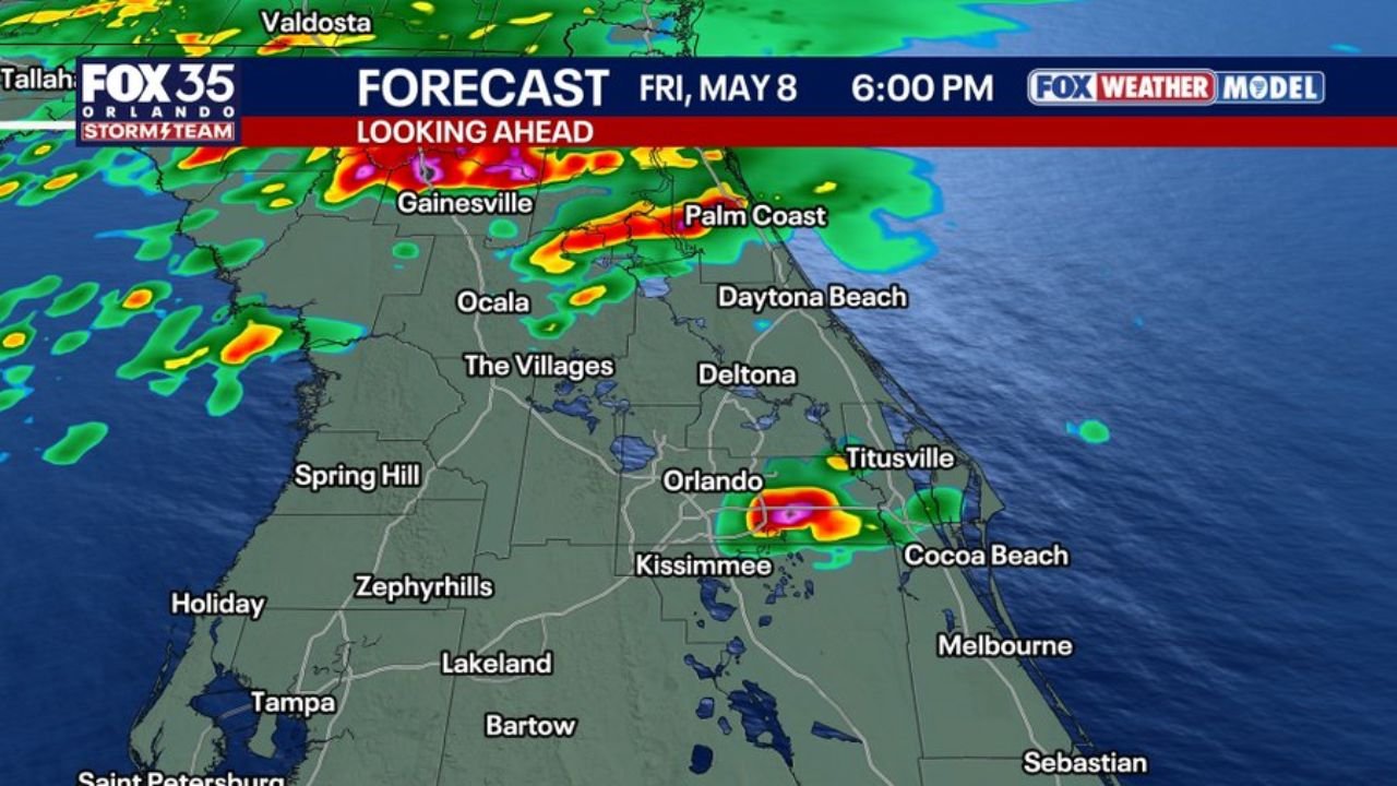
Forecast Radar at 6:00 PM Friday May 8
The forecast model valid 6:00 PM Friday May 8 shows:
- Intense red and purple cores near Gainesville and Palm Coast — the heaviest and most dangerous cells concentrated along the northeast Florida corridor
- Active cells near Orlando, Kissimmee and Titusville — a separate cluster of intense storms pushing toward the Space Coast
- Cocoa Beach and the Brevard County coast in the path of the Orlando cluster as it moves east through the evening
- Daytona Beach and Deltona sitting between the two main storm clusters with rain coverage across the full corridor
What Central Florida Residents Should Do Friday
- Plan outdoor activities for the morning hours — the threat window opens Friday afternoon and peaks through the evening, making morning the safest window for any outdoor plans
- Large hail can damage vehicles and roofs — if a severe storm warning is issued for your area, move vehicles into a garage or covered parking if possible
- Do not stand near windows during the heaviest cores — large hailstones at the size being discussed can break glass
- The threat is Level 1 out of 5 — this is not an extreme severe weather event but individual strong storms can still produce locally damaging conditions
- Monitor radar closely between 3 PM and 8 PM as storm initiation and intensification will happen quickly once the frontal boundary pushes through
WaldronNews.com will continue tracking Friday’s severe storm threat across central Florida and will provide updates as storms develop and any warnings are issued through the afternoon and evening.