
North Dakota, Minnesota and the Gulf Coast Face Below Normal Rainfall This Summer While Kansas, Colorado and the Ag Belt See Above Normal Precipitation June Through August
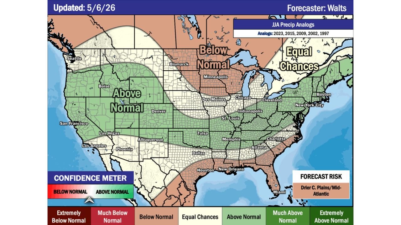
MINNEAPOLIS, Minnesota — The June through August 2026 precipitation outlook updated May 6, 2026 shows a sharp split across the United States this summer, with the Northern Plains and much of the Southern Coastline facing below normal rainfall while the Agricultural Belt from Kansas through Colorado and the Pacific Northwest is favored for above normal precipitation. The forecast is based on analog years 2023, 2015, 2009, 2002 and 1997 and carries a confidence meter leaning slightly toward above normal on the scale, with the primary forecast risk identified as drier conditions across the central Plains and Mid-Atlantic.
Summer Rainfall Outlook by Region
Below Normal — Northern Plains and Southern Coast:
- Bismarck and North Dakota — below normal rainfall through the summer
- Minneapolis and Minnesota — below normal favored through June, July and August
- Houston, New Orleans and the Gulf Coast — below normal precipitation along the southern coastline
- Miami and South Florida — below normal rainfall this summer
- Charlotte and portions of the Southeast coastline — trending below normal
Above Normal — Ag Belt and West:
- Kansas, Oklahoma and Tulsa corridor — above normal precipitation favored, providing potential drought relief heading into summer
- Denver and Colorado — above normal rainfall through the summer months
- Des Moines, St. Louis and the central Ag Belt — above normal favored, critical for corn and soybean development
- Pacific Northwest including Seattle and Boise — above normal precipitation continuing through summer
- Las Vegas, Phoenix and the Southwest — above normal moisture signal
Equal Chances — Neither Above nor Below Normal:
- Boston, New York City, Cleveland and the Great Lakes corridor — near normal conditions with no strong signal either direction
- Indianapolis and Chicago — equal chances zone sitting between the above and below normal regions
What the Forecast Risk Means
The forecast risk is explicitly identified as drier central Plains and Mid-Atlantic — meaning if this forecast verifies on the dry side of its uncertainty range, Kansas, Oklahoma, the central Plains and the Mid-Atlantic states would see the worst outcomes. For the central Plains already dealing with drought conditions heading into summer, a drier-than-forecast outcome would push drought to critical levels through the growing season.
Why This Matters for Agriculture
The above normal signal across the Ag Belt from Kansas through Iowa and Missouri is the most significant finding in this outlook for agricultural interests. Corn and soybean development through July requires consistent moisture — an above normal summer rainfall signal directly over the top corn and soybean producing counties provides the best possible backdrop for crop development after a dry spring. However the forecast risk of drier central Plains means this outcome is not guaranteed and monitoring weekly rainfall totals through June will be critical.
What to Watch This Summer
- Northern Plains farmers in North Dakota and Minnesota face a below normal rainfall summer on top of existing dry conditions — drought expansion is the primary risk for this region through August
- Gulf Coast communities from Houston through Miami should prepare for a drier than normal summer with reduced tropical rainfall and elevated fire danger during dry spells
- Kansas and Colorado sit in the above normal zone but the forecast risk flags drier central Plains as the primary uncertainty — do not assume drought recovery is guaranteed
- The Mid-Atlantic including Washington D.C., Virginia and Maryland already running significant rainfall deficits faces the additional risk of a drier than normal summer if the forecast risk scenario verifies
- The Pacific Northwest continues its above normal moisture signal through summer — fire season risk in this region remains lower than average if the outlook holds
WaldronNews.com will continue tracking the summer precipitation outlook and drought conditions across the United States and will provide updates as the June through August pattern develops.