
Texas Faces Enhanced Risk of Hurricane Force Wind Gusts Over 74 mph and Very Large Hail Sunday as Dallas, Abilene, Austin and Killeen Sit Inside the Highest Danger Zone
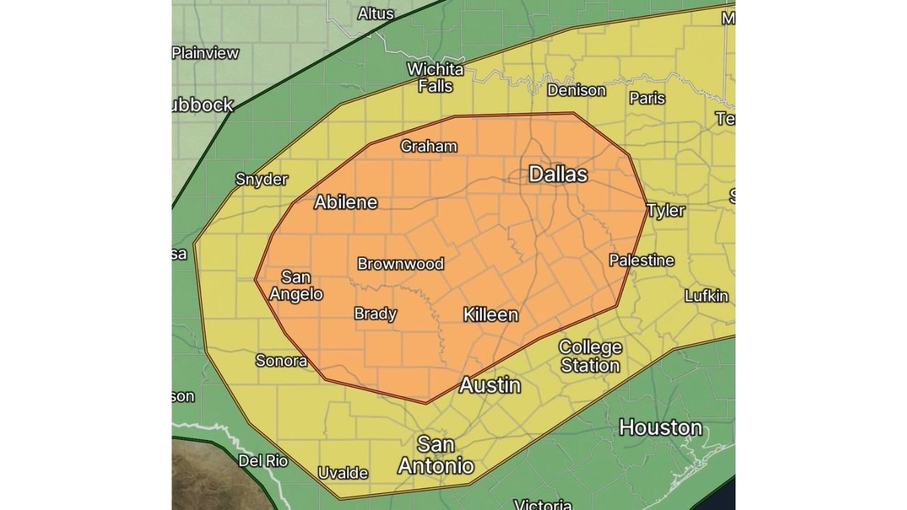
DALLAS, Texas — An Enhanced Risk of severe weather, level 3 out of 5, is in place for northern and central Texas on Sunday May 10, 2026, with Dallas, Abilene, Austin and Killeen sitting inside the highest danger zone. Widespread convection is expected to develop along a southward-sagging cold front by early afternoon, beginning with discrete supercells capable of very large hail before storms quickly congeal into an intense squall line producing wind gusts in excess of 74 mph — hurricane force. This is one of the more significant severe weather setups Texas has seen this spring.
Who Is Inside the Enhanced Risk Zone
The orange Enhanced Risk zone covers:
- Dallas and the DFW metroplex
- Abilene
- Killeen and the central Texas corridor
- Austin
- Brownwood and Brady
- Graham and Wichita Falls southern fringe
- Tyler and Palestine
- San Angelo
The Slight Risk yellow zone extends the threat to Wichita Falls, Denison, Paris, Lufkin, College Station, San Antonio and Sonora.
How the Threat Evolves Sunday
The storm sequence Sunday follows a two-phase threat:
Phase 1 — Early Afternoon Discrete Supercells:
- More organized individual storms fire first along the approaching cold front
- Very large hail is the primary hazard during this phase — supercells in this environment can produce hail well above 2 inches
- Tornado potential exists but is not the dominant threat during the discrete phase
Phase 2 — Squall Line with Hurricane Force Winds:
- Storms quickly congeal into an intense squall line as the cold front pushes south
- Wind gusts exceeding 74 mph — the threshold for hurricane force winds — become the dominant and most widespread hazard
- The squall line phase will affect the broadest geographic area in the shortest amount of time
What Hurricane Force Wind Gusts Mean on the Ground
74 mph wind gusts are equivalent to the sustained winds of a minimal hurricane or the peak gusts of a strong derecho. At this speed:
- Large trees snap or uproot across the path of the squall line
- Power lines come down causing widespread and potentially multi-day outages
- Unsecured objects become dangerous projectiles — trampolines, patio furniture, signs and lightweight structures
- Mobile homes face catastrophic damage — residents in manufactured housing must evacuate to permanent structures before the squall line arrives
- High-profile vehicles including trucks and RVs should not be on the road during the squall line passage
What Texas Residents Must Do Before Sunday Afternoon
- Secure all outdoor objects now — anything that can move in 74 mph wind should be brought inside or tied down before Sunday morning
- Identify your shelter location before storms arrive — an interior room on the lowest floor of a permanent structure away from windows
- Mobile home residents in Dallas, Abilene, Austin and Killeen must have a plan to move to a permanent structure before early afternoon Sunday
- Charge all devices and prepare for potential power outages — widespread tree damage from 74 mph gusts will bring down power lines across the Enhanced Risk zone
- Large hail will arrive before the wind threat — move vehicles to covered parking before early afternoon if possible
WaldronNews.com will continue tracking Sunday’s severe weather threat across northern and central Texas and will provide updates as storms develop and warnings are issued throughout the day.