
Gulf Coast and Florida Face Storms Through Mother’s Day Sunday as Large Storm System Pushes Frontal Line From the Western Gulf Into the Florida Peninsula
NEW ORLEANS, Louisiana — A large and active storm system over the western Gulf of Mexico is producing an impressive convective cluster as of Saturday May 9, 2026 at 1745 UTC, with 1,151 total lightning flashes detected by the GOES-19 Geostationary Lightning Mapper across the Gulf and adjacent land areas. The system is not tropical but is drawing attention for its size and intensity on satellite. A frontal line is expected to push storms through the upper Gulf Coast and into the Florida peninsula through Mother’s Day Sunday, and forecasters are watching whether the Gulf system produces any additional storm activity over Florida tomorrow.
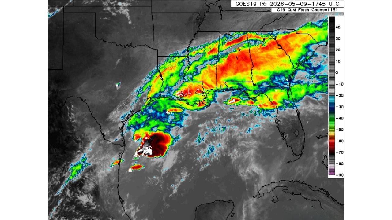
What Satellite Shows at 1745 UTC Saturday
The GOES-19 infrared satellite image shows:
- A deep convective cluster over the western Gulf with the coldest cloud tops in the black and white range — indicating cloud tops exceeding -80 to -90 degrees Celsius — towering convection reaching well into the upper atmosphere
- A broad shield of cold cloud tops stretching from the western Gulf northward through Louisiana, Mississippi and Alabama in red and orange shading indicating widespread deep convection
- The frontal line clearly defined along the Gulf Coast pushing east-northeast through the region
- 1,151 lightning flashes across the entire system confirming extremely active thunderstorm coverage from the western Gulf through the Southeast
Who Faces Storms Through Mother’s Day
- Western Gulf Coast including southern Louisiana and coastal Texas — directly under the most intense convection as of Saturday afternoon
- Mississippi and Alabama Gulf Coast — the frontal line pushing storms through this corridor into the evening
- Florida peninsula — the front is expected to push into Florida through Sunday May 10, with forecasters watching for any extra storm development from the Gulf moisture interaction
- Upper Gulf communities from New Orleans through Mobile and Pensacola — in the path of the frontal passage through tonight and into Sunday morning
What to Watch Through Mother’s Day Sunday
- The Gulf system is not tropical but is producing significant convection and lightning — treat any storms that move onshore from this system as capable of heavy rainfall, frequent lightning and gusty winds
- The frontal line push into Florida is the primary concern for Sunday — any enhancement from the Gulf moisture could produce stronger storms than the front alone would generate
- 1,151 lightning flashes in the current system means anyone along the Gulf Coast from Louisiana through Florida should avoid outdoor exposure during active storm periods
- Mother’s Day outdoor plans across the Gulf Coast and Florida should have a backup indoor option ready given the active frontal passage expected through Sunday
WaldronNews.com will continue tracking the Gulf Coast frontal system and its push into Florida through Mother’s Day and will provide updates as storms develop and move onshore Sunday.