
Ohio, Michigan, Indiana and Illinois Face Four Rounds of Rain This Week With 1 to 2 Inches Possible Near the Great Lakes as Systems Move Through Tuesday, Wednesday, Friday and Saturday
CLEVELAND, Ohio — The coming week brings four separate rain opportunities across the Great Lakes and Midwest, with systems moving through on Tuesday, Wednesday, Friday and Saturday May 12 through May 16, 2026. The heaviest totals of 1 to 2 inches will be concentrated across the lower Great Lakes region including Cleveland, Toledo, Columbus and the Detroit corridor as multiple systems stack through the week. Here is a breakdown of each round.
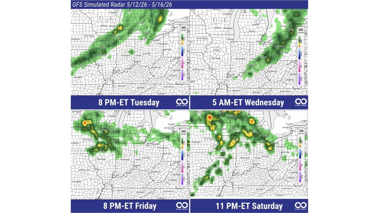
Four Rain Systems This Week
Round 1 — Tuesday May 12, 8 PM ET:
- Rain corridor pushing through from Iowa and Illinois into Indiana, Ohio and toward Buffalo and Toronto
- Indianapolis, Dayton and Columbus in the path of the Tuesday evening system
- Heavy cores indicated near the Wisconsin and Minnesota border pushing east
- Jefferson City and St. Louis catching the southern fringe of this system
Round 2 — Wednesday May 13, 5 AM ET:
- A second system moves through the Great Lakes corridor overnight into early Wednesday morning
- Chicago, Toledo, Cleveland and Columbus in the main rainfall corridor
- Rain pushing east toward Pittsburgh and the Appalachian foothills by Wednesday morning
- Springfield and Indianapolis catching the trailing edge
Round 3 — Friday May 15, 8 PM ET:
- A third system arrives Friday evening with the heaviest cores developing near Green Bay, Madison and Milwaukee
- Cedar Rapids and Des Moines catching significant rainfall on the western edge
- Cleveland and Youngstown sitting in the path of the Friday evening system
- Intense cores indicated in yellow and orange near the Wisconsin corridor
Round 4 — Saturday May 16, 11 PM ET:
- The most widespread and intense system of the week arrives Saturday night
- Deep red and orange cores indicated near Madison and the Wisconsin and Illinois border
- Cedar Rapids, Des Moines and Springfield catching heavy rainfall
- Indianapolis, Dayton and Columbus in the path of the Saturday night system pushing toward Pittsburgh and the Mid-Atlantic
- This round coincides with the beginning of the mid-May pattern shift toward more active severe weather
Where the Heaviest Totals Land
- Lower Great Lakes corridor including Cleveland, Toledo, Columbus and Detroit: 1 to 2 inches total through the full week as all four systems pass through
- Indianapolis and central Indiana: Multiple rounds adding up to meaningful totals through the week
- Chicago and Milwaukee: Above normal weekly rainfall from the combined four systems
- Cedar Rapids and Des Moines: Significant rainfall particularly from the Friday and Saturday systems
What to Watch This Week
- Drivers on Tuesday and Wednesday evenings across Indiana, Ohio and the Great Lakes should expect reduced visibility and slick roads as the first two systems push through
- The Friday and Saturday systems are the stronger of the four and arrive as the mid-May pattern begins shifting toward the more active severe weather period flagged in long-range guidance
- Flood-prone areas near Cleveland, Columbus and Toledo should monitor rainfall accumulations as four systems in five days can push totals into ranges that stress drainage systems
- Saturday night’s system in particular should be watched for any severe weather potential as it arrives coinciding with the pattern shift toward more active conditions after May 16
WaldronNews.com will continue tracking this week’s rain pattern across Ohio, Michigan, Indiana and Illinois and will provide updates as each system approaches the Great Lakes corridor.