
Florida Faces Impressive Supercell With Large Hail in Osceola County Near Holopaw, Deer Park and Kenansville Tuesday May 12 This Afternoon
KISSIMMEE, Florida — A fairly impressive supercell is active this afternoon in rural Osceola County, Florida, near Holopaw, Deer Park and Kenansville, capable of producing large hail and expected to remain organized for some time due to moderate instability and strong upper-level wind shear in the atmosphere.
The cell is considered mostly non-tornadic given very weak low-level wind shear, but the large hail threat remains real for rural Osceola County communities this Tuesday, May 12, 2026 afternoon.
What Radar Is Showing Right Now
Super-resolution Doppler radar is showing a well-defined supercell over rural Osceola County near Holopaw and Kenansville:
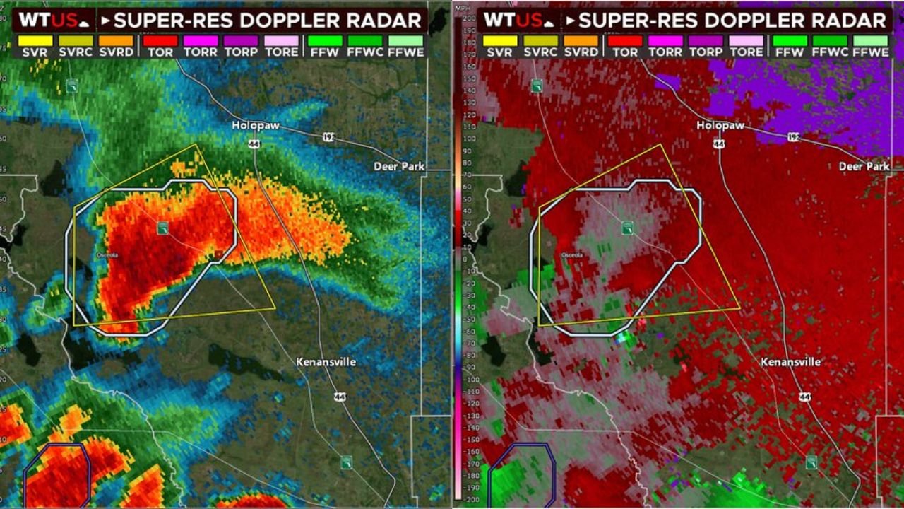
- The reflectivity radar on the left shows intense red and orange colors within a clearly outlined storm cell near Osceola County, indicating a very strong storm core with heavy precipitation and hail present within the cell right now.
- The velocity radar on the right shows the broad wind field associated with this supercell across the Holopaw, Deer Park and Kenansville area, with the storm maintaining an organized rotating structure visible on super-resolution Doppler.
- Warning polygons are outlined on both radar panels covering the Osceola County area near Holopaw and Kenansville, indicating active severe weather warnings in place for this storm this afternoon.
Large Hail the Primary Threat
Large hail is the main concern with this Osceola County supercell this afternoon:
- Moderate instability combined with strong deep-layer wind shear, meaning winds at higher levels of the atmosphere are significantly stronger than winds near the surface, gives this supercell the energy it needs to produce large hailstones within the storm’s rotating updraft.
- The storm is expected to remain maintained and organized for some time, meaning the large hail threat will persist across rural Osceola County near Holopaw, Deer Park and Kenansville through the afternoon hours.
- Anyone in or near Holopaw, Deer Park or Kenansville should move vehicles under covered shelter immediately and get indoors as large hail can cause serious injury and significant property damage within seconds of it beginning to fall.
Why the Tornado Threat Is Low
Despite being a supercell, which is the storm type most associated with tornadoes, this particular storm faces a significant limiting factor for tornado production:
- Very weak low-level wind shear is the key reason this cell is considered mostly non-tornadic this afternoon. Low-level wind shear is the change in wind direction and speed between the surface and about a mile up in the atmosphere, and it is the primary ingredient needed for a storm to produce a tornado close to the ground.
- Without strong low-level wind shear, even an organized rotating supercell like the one currently over Osceola County will struggle to produce the tight near-surface rotation needed to generate a tornado.
- However, residents near Holopaw, Deer Park and Kenansville should not completely dismiss the tornado risk. Supercells can occasionally produce brief tornadoes even in low shear environments, and any change in the low-level wind field this afternoon could quickly alter the tornado potential with very little warning.
What Residents Near Holopaw and Kenansville Should Do Now
Anyone in rural Osceola County near Holopaw, Deer Park and Kenansville should take action immediately:
- Get indoors now and move to an interior room away from windows if a severe thunderstorm warning is in effect for your location. Large hail from a supercell can reach dangerous sizes quickly once the storm becomes fully established.
- Move all vehicles under covered shelter immediately as large hail can total an unprotected vehicle within minutes during a supercell hail event across Osceola County.
- Keep weather alerts active through the remainder of the afternoon as this storm is expected to remain organized for some time and could affect additional communities as it tracks across Osceola County.
WaldronNews.com will continue tracking this supercell and large hail threat across Osceola County, Florida near Holopaw, Deer Park and Kenansville and will provide updates as hail reports, storm organization and warning status develop through Tuesday, May 12 afternoon.