
Kansas Faces 2 Inch Hail and Sporadic Damaging Gusts Near Salina, Emporia, Wichita, Topeka and McPherson Thursday May 14 After 4:00 PM
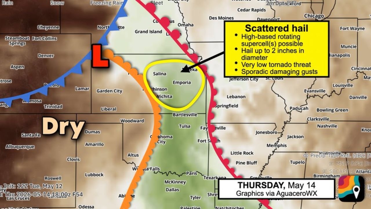
WICHITA, Kansas — Scattered hailstorms are on the way for Kansas on Thursday, May 14, 2026, with hail up to 2 inches in diameter and sporadic damaging gusts possible across a concentrated zone including Russell, Salina, Topeka, McPherson, Emporia and Wichita after 4:00 PM.
Storms are expected to remain as lone, discrete supercells through approximately 9:00 PM before potentially merging into windy lines or clusters during the evening hours, with the tornado threat remaining minimal throughout the event.
Where and When Storms Develop Thursday
A dryline pushing into Kansas from the west is the trigger for Thursday’s storm development, with the concentrated risk zone circled directly over Salina, Emporia, Wichita and Topeka:
- The dryline is the leading edge of dry air clashing with a slightly more humid air mass to the east across Kansas. This collision of air masses will cause a few storms to bubble up after 4:00 PM Thursday, May 14 across the risk zone.
- Storms will likely remain suppressed during the daylight hours before 4:00 PM due to a strong cap, which is a layer of hot dry air sitting about a mile up in the atmosphere that acts like a lid preventing surface air from rising and forming storms until enough energy builds to break through it.
- Once storms break through the cap after 4:00 PM, they are expected to develop as lone discrete supercells, meaning individual rotating storms rather than a widespread line, which is the storm type most capable of producing very large hail.
- Parts of Interstate 70 and Interstate 35 through the Kansas Turnpike corridor fall within the risk zone, meaning travelers on these highways should be aware of rapidly developing hailstorms after 4:00 PM Thursday.
Hail Up to 2 Inches Possible
The primary threat with Thursday’s supercells is large to very large hail:
- Hail up to 2 inches in diameter, roughly the size of a golf ball to pool ball, is possible if supercells become established across the Salina, Emporia, Wichita and Topeka risk zone after 4:00 PM Thursday, May 14.
- At 2 inches, hail falls fast enough to shatter vehicle windshields, break windows, destroy vehicle roofs and cause significant damage to roofing, siding and any crops in the path of the storm within minutes of the hail beginning to fall.
- Changing winds with height will help these storms spin and produce big hail, meaning the atmospheric setup on Thursday is specifically favorable for hail production rather than for tornadoes or straight-line wind damage.
Tornado Threat Minimal
Despite the supercell potential, the tornado threat for Thursday, May 14 across Kansas remains very low:
- Somewhat dry surface air across the Kansas risk zone will keep the tornado threat minimal throughout the Thursday event, even if supercells become established after 4:00 PM.
- Sporadic damaging gusts are possible with any supercell that develops, but these gusts will be secondary in importance to the primary hail threat across Salina, Emporia, Wichita and Topeka.
- High-based rotating supercells, meaning storms with cloud bases higher above the ground than typical supercells, are the most likely storm type Thursday and these tend to favor hail production over tornado production given the drier surface air in place.
Evening Merger Into Lines
As Thursday evening progresses past 9:00 PM, the storm character may shift:
- Storms that develop as discrete supercells after 4:00 PM may grow and merge into one or more windy lines or clusters during the evening hours, shifting the primary threat from large hail to sporadic damaging wind gusts across a broader area of Kansas.
- Residents across Salina, Emporia, Wichita, Topeka and McPherson should remain weather alert through the full evening hours of Thursday, May 14 even after the initial supercell phase ends around 9:00 PM.
What to Do Before 4 PM Thursday
Residents across Russell, Salina, Topeka, McPherson, Emporia and Wichita have time to prepare before storms develop:
- Move all vehicles into covered parking or a garage before 4:00 PM Thursday, May 14 as hail up to 2 inches can total a vehicle within minutes and covered shelter is the only reliable protection from large hail damage.
- Enable severe thunderstorm alert notifications on your phone now so any warnings issued after 4:00 PM Thursday reach you immediately.
- Travelers on Interstate 70 and Interstate 35 through the Kansas Turnpike corridor should plan their routes to avoid the Salina to Topeka zone during the 4:00 PM to 9:00 PM supercell window if possible.
WaldronNews.com will continue tracking scattered hailstorms and supercell development across Kansas including Salina, Emporia, Wichita, Topeka and McPherson and will provide updates as storm timing, hail size reports and evening merger activity develop through Thursday, May 14.