
Maryland, Virginia and Pennsylvania Face Two Lines of Showers and Thunderstorms Wednesday May 13 Evening With Low Severe Risk West of Frederick and Temps Boosting Into the 70s
BALTIMORE, Maryland — Wednesday, May 13, 2026 evening and night could get bumpy across Maryland, Virginia and Pennsylvania, with perhaps two lines of showers and thunderstorms pushing through the region between 6:00 PM and 10:00 PM as temperatures boost into the 70s ahead of an approaching cold front.
The severe risk is low and focused mainly west of Frederick, Maryland, with storm lines forecast to push through Baltimore, Washington, Hagerstown, Harrisburg and Winchester through the evening hours.
Storm Timing Wednesday Evening
Simulated radar shows two lines of storms tracking through the region across three key time snapshots this evening:
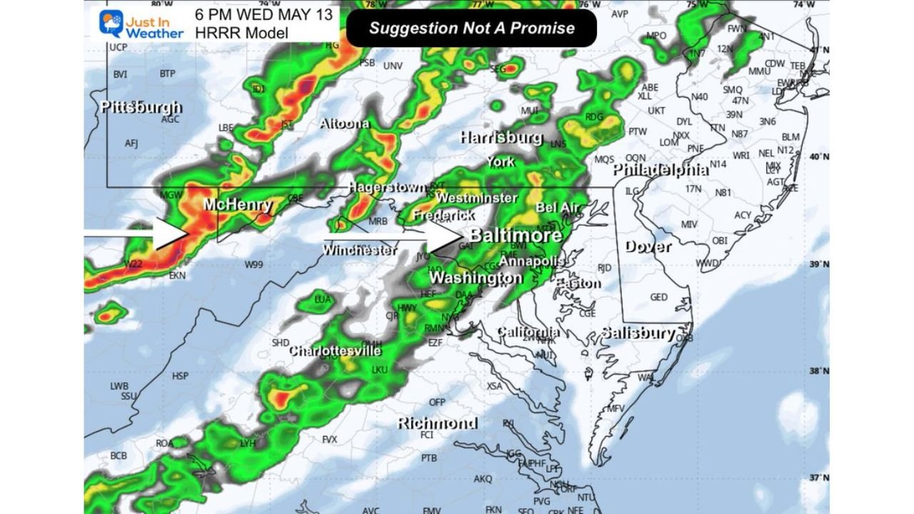
- At 6:00 PM Wednesday, May 13, the first line of storms is shown pushing through McHenry, Maryland and Hagerstown, Maryland westward toward Pittsburgh, Pennsylvania, with a second band approaching Baltimore, Washington and Annapolis from the west. Frederick, Westminster and Bel Air, Maryland are all in the path of incoming storm activity by 6:00 PM.
- By 8:00 PM Wednesday, May 13, the storm lines have pushed eastward with McHenry and Winchester, Virginia still seeing active cells while Baltimore, Washington, Hagerstown and York, Pennsylvania are within the storm corridor. Charlottesville, Virginia and Richmond, Virginia are also showing storm activity on the 8:00 PM simulated radar.
- By 10:00 PM Wednesday, May 13, storms have pushed further east with Baltimore, Washington, Frederick, Westminster and Bel Air all still within the active storm zone. Harrisburg and York, Pennsylvania are tracking heavy cells at 10:00 PM while Philadelphia, Pennsylvania sits on the eastern edge of the incoming storm activity.
Low Severe Risk West of Frederick
The severe weather risk with tonight’s storm lines is low but not zero, particularly for communities west of Frederick, Maryland:
- The primary severe risk is focused mainly west of Frederick, Maryland, meaning communities including McHenry, Hagerstown and Winchester, Virginia face the slightly higher end of tonight’s low severe weather potential.
- Baltimore, Washington, Annapolis and Harrisburg fall east of the primary severe risk zone but will still experience active showers and thunderstorms with gusty winds possible as the two storm lines push through.
- Any storm that does reach severe levels tonight could produce gusty winds and small hail, but widespread or significant severe weather is not expected given the low overall risk assessment for this event.
Why Storms Are Possible Tonight
Temperatures boosting into the 70s ahead of the cold front are providing the fuel needed for tonight’s storm lines:
- Warm temperatures in the 70s ahead of a cold front create instability, which is the atmospheric ingredient that allows storms to develop and sustain themselves as the cold front pushes eastward through Maryland, Virginia and Pennsylvania tonight.
- Two separate lines of showers and thunderstorms are possible because the cold front itself and a pre-frontal boundary both have enough energy to trigger storm development as they push through the region between 6:00 PM and 10:00 PM.
- Temperatures will drop noticeably behind the cold front passage tonight, with conditions improving and clearing expected after the storm lines move through.
What Residents Should Expect Tonight
Residents across Baltimore, Washington, Hagerstown, Frederick, Harrisburg, Winchester and Charlottesville should plan for the following Wednesday evening:
- Expect two rounds of showers and thunderstorms between 6:00 PM and 10:00 PM as the storm lines push through from west to east across Maryland, Virginia and Pennsylvania.
- Keep weather alerts active on your phone through 10:00 PM Wednesday, May 13 especially if you are west of Frederick, Maryland where the low severe risk is most concentrated tonight.
- Wet roads and reduced visibility will affect the evening commute and any travel across Maryland, Virginia and Pennsylvania between 6:00 PM and 10:00 PM, so allow extra travel time and slow down in heavy rain.
WaldronNews.com will continue tracking these two lines of showers and thunderstorms across Maryland, Virginia and Pennsylvania including Baltimore, Washington, Hagerstown, Frederick, Harrisburg and Winchester and will provide updates as storm timing and any severe weather west of Frederick develop through Wednesday, May 13 night.